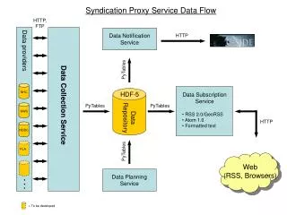
Download
1 / 15
150 likes | 297 Views
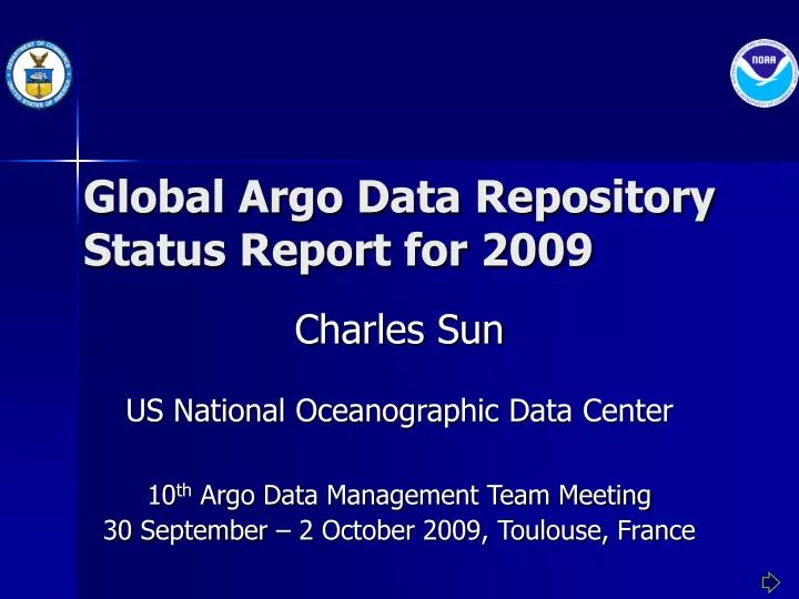
Global Argo Data Repository Status Report for 2009. Charles Sun US National Oceanographic Data Center 10 th Argo Data Management Team Meeting 30 September – 2 October 2009, Toulouse, France. Highlights of Activities. Continued daily operations of the GADR.

E N D
Global Argo Data Repository Status Report for 2009 Charles Sun US National Oceanographic Data Center 10th Argo Data Management Team Meeting 30 September – 2 October 2009, Toulouse, France
Highlights of Activities • Continued daily operations of the GADR. • Performed an automated procedure of “mirroring” a local Argo data set in sync with the Argo GDAC server at Monterey, CA. • Implemented an automated procedure for acquiring the CLIVAR & Carbon Hydrographic Data Office (CCHDO) data from the Web for archive accession. • Produced monthly archives of the Argo data archived at the NODC and populated them at http://argo.nodc.noaa.gov/ • Identified the deficiency of the Argo NetCDF format convention and developed a strategy for improving the Argo convention in compliance with the Climate and Forecast (CF) metadata convention.
GADR Web Server Statistics • Monthly average of requests (files): • 595,908 in 2007 • 1,021,903 in 2008 • 1,006,767 in 2009* • Monthly average of data download: • 23.55 GB in 2007 • 42.41 GB in 2008 • 54.57 GB in 2009* *ending August 2009
Argo Monthly Archives Web Site http://argo.nodc.noaa.gov/
Argo NetCDF Format Issue • The Geographic Coordinate System is not well-defined in the Argo individual profile NetCDF format file. • The Argo NetCDF convention is not in compliance with the CF (Climate and Forecast) metadata convention. • The CF (and COARS) NetCDF convention suggests: • Any 4-dimensional data should have four coordinates (axes), "date or time" (a.k.a. "T"), "height or depth" (a.k.a. "Z"), "latitude" (a.k.a. "Y"), or "longitude" (a.k.a. "X"). • Order of dimensions: If any or all of the dimensions of a variable have the interpretations of "date or time“, "height or depth" "latitude”, or "longitude" then those dimensions should appear in the relative order T, then Z, then Y, then X in the CDL definition corresponding to the file. • The dimension name of each coordinate variable should be the same as its variable name, i.e., time(time), depth(depth), latitude(latitude), and longitude(longitude).
What do we have in the Argo NetCDF format files? variables: double JULD (N_PROF) ; JULD:long_name = “…" ; float PRES(N_PROF, N_LEVELS) ; PRES:long_name = “…" ; float TEMP(N_PROF, N_LEVELS) ; TEMP:long_name = “…”; float PSAL(N_PROF, N_LEVELS) ; PSAL:long_name = “…." ; … netcdf R7900061_058 { dimensions: DATE_TIME = 14 ; … ; N_PROF = 1 ; N_PARAM = 3 ; N_LEVELS = 454 ; N_CALIB = 1 ; N_HISTORY = UNLIMITED ; // (2 currently) data: JULD = 21788.3671064973 ; LATITUDE = -53.5970001220703 ; LONGITUDE = 6.85099983215332 ; PRES = 2.0, 4.0, 6.0, … TEMP = -1.244, -1.244, -1.244, … PSAL = 33.919, 33.920, 33.919, ...
Annoying and Inconvenient! What’s the Issue? Use a generic NetCDF browser, “ncBrowse”, to illustrate the Argo NetCDF format issue.
Profile Plot Comparison Original Format Profile Plot Modified Format Profile Plot
Suggestions of Format Changes (shown in red) variables: double JULD (N_PROF) ; double TIME(TIME) ; float PRES(N_PROF, N_LEVELS) ; float PRES(PRES) ; float TEMP(N_PROF, N_LEVELS) ; float TEMP(TIME,PRES,LATITUDE,LONGITUDE) ; float PSAL(N_PROF, N_LEVELS) ; float PSAL(TIME,PRES,LATITUDE,LONGITUDE) ; … netcdf R7900061_058_mod { dimensions: DATE_TIME = 14 ; … ; N_PROF = 1 ; N_PARAM = 3 ; N_LEVELS = 454 ; N_CALIB = 1 ; N_HISTORY = UNLIMITED ; // (2 currently) TIME = 1 ; PRES = 454 ; LONGITUDE = 1 ; LATITUDE = 1 ;
Other Suggestions for Improvements • Spell out whole variable names, such as “pressure” instead of “PRES”, “temperature” or “sea_temperature” instead of “TEMP” etc. • Use lower case for all variable names.
Future Plan • Continue GADR operations. • Continue to acquire the CCHDO data via the Internet on a quarterly basis. • Continue to populate the Argo data archives on a monthly basis .