Download
1 / 25
270 likes | 391 Views
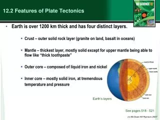
12.2 Features of Plate Tectonics. Earth is over 1200 km thick and has four distinct layers. Crust – outer solid rock layer (granite on land, basalt in oceans) Mantle – thickest layer, mostly solid except for upper mantle being able to flow like “thick toothpaste”

E N D
12.2 Features of Plate Tectonics • Earth is over 1200 km thick and has four distinct layers. • Crust – outer solid rock layer (granite on land, basalt in oceans) • Mantle – thickest layer, mostly solid except for upper mantle being able to flow like “thick toothpaste” • Outer core – composed of liquid iron and nickel • Inner core – mostly solid iron, at tremendous temperature and pressure Earth’s layers See pages 518 - 521 (c) McGraw Hill Ryerson 2007
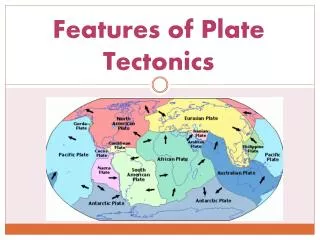
12.2 Features of Plate Tectonics • Tectonic plates make up the lithosphere, which floats on the asthenosphere. • The lithosphere is the crust and upper portion of the upper mantle. • The asthenosphere is the molten layer of the upper mantle. • Heat to keep the asthenosphere molten comes from radioactive elements. Earth’s layers See pages 518 - 521 (c) McGraw Hill Ryerson 2007
Plate Motion (continued) • Continents, attached to the tectonic plates, float in the magma of the asthenosphere. • As magma is heated in the asthenosphere, convection currents form. • Rising magma can reach the surface at ridges (in the oceans) or rifts (on land). • The magma cools when it reaches the surface, solidifies, and is pushed aside as new magma pushes from below. • On the ocean this is called ridge push. • On land: rift valley See pages 520 - 522 (c) McGraw Hill Ryerson 2007
Plate Motion (continued) • There are 12 large tectonic plates and many smaller ones. • Where continental and oceanic plates meet, subduction occurs. • The denser oceanic plate subducts under the lighter continental plate. • By “slab pull,” the rest of the plate follows. • Large earthquakes and volcanoes are found in subduction zones. See pages 520 - 522 (c) McGraw Hill Ryerson 2007
Plate Interactions Tectonic plate boundaries, and their relative movement to each other. See page 523 (c) McGraw Hill Ryerson 2007
Plate Interactions • A plate boundary an area where two plates are in contact. • The way the plates interact is based on the type of plate and the direction the plates are moving relative to each other. • Divergent plate boundaries – areas where plates are spreading apart • Convergent Plate boundaries – areas where plates meet • Transform plate boundaries – areas where plates move past each other See page 523 (c) McGraw Hill Ryerson 2007
Plate Interactions (continued) Photo southeast of Anchorage near the 1964 epicentre. Before the earthquake, the tree would have been well above tide level. Now, the tree stump is clearly below high tide mark. See pages 523 - 525 (c) McGraw Hill Ryerson 2007
Plate Interactions (continued) Divergent plate boundaries are areas where plates are spreading apart. • Ocean ridges and continental rifts are examples. • The Mid-Atlantic Ridge is the longest mountain range on Earth. See pages 523 - 525 (c) McGraw Hill Ryerson 2007
Plate Interactions (continued) Convergent plate boundaries are areas where plates collide. • Oceanic-continental plate convergence • The oceanic plate subducts under the continental plate, forming a trench. • Cone-shaped volcanoes can form from magma seeping to the surface. • This is how the volcanic belt of the North America’s west coast has formed. • Mountain ranges like the Coast Mountain range also form from the collision. • Earthquakes can occur when subduction, ridge push, and slab pull stall. The convergence of an oceanic and a continental plate. See pages 523 - 525 (c) McGraw Hill Ryerson 2007
Plate Interactions (continued) Oceanic-oceanic plate convergence • The cooler, denser plate will subduct under the less dense plate. • Convergence may produce a volcanic island arc, such as those found in Japan, Indonesia, and Alaska’s Aleutian islands. See pages 523 - 525 (c) McGraw Hill Ryerson 2007
Plate Interactions (continued) Continental-continental plate convergence • Since both are continental plates, their densities are similar. • As they collide, their edges fold and crumple, forming mountain ranges. • The Himalayas are the world’s youngest (and tallest) mountain range, formed as Asia and Africa plates collided 40 million years ago. • They are still growing taller today. See pages 523 - 525 (c) McGraw Hill Ryerson 2007
Plate Interactions (continued) Transform plate boundaries are where plates move past each other. • Usually are found near ocean ridges • Since rock slides past rock, no mountains or volcanoes form. • Earthquakes and faults are very common. Note: shift in fence position as a result of the 1906 earthquake at Point Reyes Station (San Andreas fault) Transform boundary San Andreas fault
Plate Interactions (continued) • Earthquakes often form from the friction between moving tectonic plates. • This accounts for 95 percent of all earthquakes. • The Juan de Fuca convergent plate boundary west of Vancouver Island has many earthquakes. • Large earthquakes hit this region every 200 to 800 years. Transform boundary Pillow basalt: formed by undersea volcano – see sample in Room 325 San Andreas fault (c) McGraw Hill Ryerson 2007
Describing Earthquakes • Earthquakes are very difficult to predict. • Scientists understand why they happen, but it is very difficult to predict their timing, exact location, and strength. • Their pressure build-up happens underground, over very long periods of time. • What we do understand has helped us to prepare structures to survive them. • The focus of the earthquake is where the pressure is finally released. • The epicentre is the point on the surface directly above the focus. See page 528 (c) McGraw Hill Ryerson 2007
Describing Earthquakes • Earthquakes occur at various depths, depending on the plates involved. • Earthquakes at the surface tend to cause more damage. See page 528 (c) McGraw Hill Ryerson 2007
Describing Earthquakes (continued) • Earthquakes produce seismic waves. • Seismology is the study of these waves. • These waves reveal the source and strength of an earthquake. • They also help us learn about the composition and distances of the Earth’s interior. See page 529 (c) McGraw Hill Ryerson 2007
Describing Earthquakes (continued) • Types of earthquake waves: See page 529 (c) McGraw Hill Ryerson 2007
Describing Earthquakes (continued) • Seismic waves behave differently in different Earth layers. • Knowing this, scientists can learn about earthquakes and Earth’s interior. See pages 530 - 531 (c) McGraw Hill Ryerson 2007
Describing Earthquakes (continued) • Seismometers are used to measure seismic wave energy. • Early seismometers just measured whether the ground shook. • Some seismometers measure horizontal movement, others vertical movement. • A seismogram is produced, showing when an earthquake started, how long it lasted, and the magnitude. • Since seismic waves travel at different speeds, a distance-time graph can reveal the focus. See pages 530 - 531 (c) McGraw Hill Ryerson 2007
Describing Earthquakes (continued) • 1 increase in magnitude = 10X stronger • A magnitude 6 earthquake is 100X more powerful than a 4. See pages 530 - 531 (c) McGraw Hill Ryerson 2007
Volcanoes • The movement of tectonic plates causes volcano formation. Composite volcanoes – found along plate boundaries • Layers of ash and thick lava form a tall cone. • As magma reaches the surface, it cools, hardens, and traps gases below. • Pressure builds; eventually, there is an eruption. Mount St. Helens is composite volcano. See pages 532 - 534 (c) McGraw Hill Ryerson 2007
Volcanoes Shield volcanoes – these are not found at plate boundaries but instead form over hot spots. • Thin magma/lava flows out from a hot spot and forms a low, wide cone. • The Hawaiian Islands are an example of a chain of shield volcanoes. Mauna Loa in Hawaii is a composite volcano. (c) McGraw Hill Ryerson 2007
Volcanoes Rift eruptions – occur along long cracks in the lithosphere • These are not explosive, but they release massive amounts of lava. Rift valley volcano See pages 532 - 534 Take the Section 12.2 Quiz (c) McGraw Hill Ryerson 2007
Youtube links • http://www.youtube.com/watch?v=BbTFkPxwhTM&feature=related Mt Etna eruption • http://www.youtube.com/watch?v=vBJ9xZws7ro&feature=related Mt. St. Helens eruption • http://www.youtube.com/watch?v=eHv7J4nvXpE National Geographic volcanologist enter volcanic caldera • http://www.youtube.com/watch?v=2IvX4XNS5BU&feature=related lava flow • http://www.youtube.com/watch?v=NQzGjGKdGvQ&feature=related images of aftermath of Mt. Pinatubo eruption – turn down music • http://www.youtube.com/watch?v=5GpEoQKC0kE&feature=related images of Dec 26, 2004 Tsunami – Phillipines • http://www.youtube.com/watch?v=G8Fy8CNu11U&feature=related animal survival during Tsunami • http://www.youtube.com/watch?v=DeBPg8nCpiA tsunami in Port Alberni (March 1964) – watch first 2 minutes only – rest is inconsequential • http://www.youtube.com/watch?v=ifke1GsjNN0&feature=related plate tectonics explained • http://www.youtube.com/watch?v=hjo4I0Ehjcc preparedness kit • http://www.youtube.com/watch?v=6PRBY4hseO4&feature=related 1964 Alaska photos post earthquake • http://www.youtube.com/watch?v=kGVnnkxQ8hM&feature=related earthquake video 2 – Japan • http://www.youtube.com/watch?v=O7qngjS38NA&feature=related earthquake video 3 – Japan • http://www.youtube.com/watch?v=KLZFlnND0hA&feature=related earthquake induced liquifaction – bad video quality, excellent images • http://www.youtube.com/watch?v=HHgonW70DX0&feature=PlayList&p=53B48FAAF6147771&index=9 tsunami wave as a result of 1960 earthquake off Chile • http://www.youtube.com/watch?v=vxXf-dYtG7Q 9.5 earthquake off Chile – look at first 1:40 • http://www.youtube.com/watch?v=U5GSeNGy8LI&feature=related earthquake in Sichuan, China May 2008, 7.8 Richter • OTHER • http://www.pep.bc.ca/hazard_preparedness/Earthquake_photos.html pictures from BC earthquake preparedness site • http://www.pep.bc.ca/hazard_preparedness/Earthquake_Information.html BC preparedness site (c) McGraw Hill Ryerson 2007