Climate Upper-Air Observation Training Workshop
170 likes | 280 Views
Join the NOAA/GCOS Workshop to Define Climate Requirements for Upper-Air Observations, focusing on meteorological parameters, tools, and precision measurements. Learn about upper-air sounding, in situ and remotely sensed observations, crucial parameters like temperature, pressure, and ozone concentration, and advanced tools such as Radiative Transfer Models. Explore measurement accuracy, stability, and the role of instruments like Radiosondes and GPS in climate studies. Gain insights into acronyms like GCOS, GUAN, and UNFCCC shaping climate observation networks.

Climate Upper-Air Observation Training Workshop
E N D
Presentation Transcript
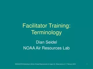
Facilitator Training: Terminology Dian Seidel NOAA Air Resources Lab NOAA/GCOS Workshop to Define Climate Requirements for Upper-Air Observations, 8-11 February 2005
Types of Terms Covered • Meteorological • Observations • Parameters • Instruments • Tools • Metrological (measurement-related) • Programmatic acronyms NOAA/GCOS Workshop to Define Climate Requirements for Upper-Air Observations, 8-11 February 2005
Met. Terms: Observations • Upper-Air: Atmosphere above the surface. • Sounding = profile – measurement of the vertical structure of a parameter in the atmosphere • In situ: in place, sensor is immersed in the air • Remotely sensed: from afar, e.g., from a satellite or a ground-based or aircraft-mounted remote sensor • Parameters, elements: physical aspects of the atmosphere to be measured NOAA/GCOS Workshop to Define Climate Requirements for Upper-Air Observations, 8-11 February 2005
Met. Terms: Upper-Air Parameters • Vertical Coordinate • Height – above ground or above sea level • Pressure - • Geopotential height • Others (isentropes, potential temperature) NOAA/GCOS Workshop to Define Climate Requirements for Upper-Air Observations, 8-11 February 2005
Met. Terms: Upper-Air Parameters • Priority 1 parameters • Temperature • Pressure: force/area due to weight of overlying air • Geopotential height: height of a given point in the atmosphere in units proportional to potential energy of unit mass at this height relative to sea level • Water Vapor: matrices use mixing ratios (g/kg), but observations may be of relative humidity, vapor pressure, specific humidity … • Wind Speed and Direction • Ozone Concentration NOAA/GCOS Workshop to Define Climate Requirements for Upper-Air Observations, 8-11 February 2005
Met. Terms: Upper-Air Parameters • Priority 2 parameters • Aerosol properties • Cloud properties • Precipitation properties • Radiation properties NOAA/GCOS Workshop to Define Climate Requirements for Upper-Air Observations, 8-11 February 2005
Met. Terms: Tools • Radiative Transfer Models (RTM) • A physical/mathematical model of how radiation passes through the atmosphere • Accounts for scattering, absorption and emission • Relates radiances to meteorological parameters (satellite observations to in situ observations) • Reanalysis / Ongoing Analysis • Climatological meteorological fields based on observations enhanced by assimilation into a weather prediction model • Spatially, temporally, and physically more complete than the original observations, so useful for climate studies NOAA/GCOS Workshop to Define Climate Requirements for Upper-Air Observations, 8-11 February 2005
Measurement-Related Terms • Measurement Accuracy: deviation of an observation from the true value, bias error • Measurement Precision: repeatability of an observation, random error • Measurement Range: span from minimum to maximum value to be observed • Long-Term Stability: changes in accuracy (bias) over time NOAA/GCOS Workshop to Define Climate Requirements for Upper-Air Observations, 8-11 February 2005
Precision and Accuracy NOAA/GCOS Workshop to Define Climate Requirements for Upper-Air Observations, 8-11 February 2005
Long-Term Measurement Stability Parameter Time NOAA/GCOS Workshop to Define Climate Requirements for Upper-Air Observations, 8-11 February 2005
Instruments: Radiosonde NOAA/GCOS Workshop to Define Climate Requirements for Upper-Air Observations, 8-11 February 2005
Instruments: Radiosonde NOAA/GCOS Workshop to Define Climate Requirements for Upper-Air Observations, 8-11 February 2005
Instruments: Ozonesonde NOAA/GCOS Workshop to Define Climate Requirements for Upper-Air Observations, 8-11 February 2005
Instruments: GPS NOAA/GCOS Workshop to Define Climate Requirements for Upper-Air Observations, 8-11 February 2005
Instruments: UAV NOAA/GCOS Workshop to Define Climate Requirements for Upper-Air Observations, 8-11 February 2005
Instruments: Other terms • Reference Radiosonde – a more highly calibrated radiosonde • Lidar – remote sensor operating on the same principles as radar, but using light, not radio, waves • Satellite orbits: geostationary vs polar orbiting NOAA/GCOS Workshop to Define Climate Requirements for Upper-Air Observations, 8-11 February 2005
Acronyms • GCOS – Global Climate Observing System • GUAN – GCOS Upper Air Network • AOPC – Atmospheric Observation Panel for Climate • GEOS – Group on Earth Observing System • WMO – World Meteorological Organization • NDSC – Network for the Detection of Stratospheric Change • UNFCCC – UN Framework Convention on Climate Change • Myriad of satellite sensor acronyms • GPS – Global Positioning System; GPSMet NOAA/GCOS Workshop to Define Climate Requirements for Upper-Air Observations, 8-11 February 2005