Download
1 / 19
280 likes | 916 Views
Locating the Epicenter of an Earthquake. The Triangulation Method. Earthquake. In an earthquake, stored energy is suddenly released through a movement along a fault. Earthquake.

E N D
Locating the Epicenter of an Earthquake The Triangulation Method
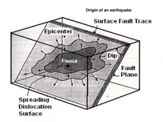
Earthquake In an earthquake, stored energy is suddenly released through a movement along a fault.
Earthquake Most earthquakes can be explained by plate tectonics. It says that the constant motion of rocks along one side of a fault boundary causes the rocks on the opposite side to bend.
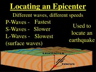
Earthquake: Seismic Waves Seismic waves emanating from the focus can travel as body waves or surface waves. Body waves (P & S Waves) travel in all directions from the focus through the body of the Earth Surface waves are different from body waves because they don’t travel through the Earth; instead they are constrained to travel along the surface of the Earth from the epicenter.
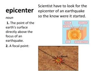
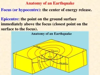
What is an Epicenter? • A point on the surface of the Earth directly above the FOCUS of the earthquake. • The point within the Earth from which earthquake waves originate. Epicenter
Properties of Seismic Waves There are two types of body waves; the compressional or P waves and the shear or S waves. P waves (or primary waves) travel with a velocity that depends on the elastic properties of the rock that they travel through.? S waves (or secondary waves) are shear waves.
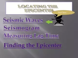
Locating the Epicenter In order to determine the location of an earthquake, the earthquake needs to be recorded on at least three different seismographs that are at significantly different locations. The other piece of information needed is the time it takes for P-waves and S-waves to travel through the Earth and arrive at a seismographic station.
The Triangulation Method TriangulationA mathematical method for locating the epicenter of an earthquake using three or more data sets from seismic stations. This data is collected using earthquake monitoring instruments called seismographs which record the seismic waves of the earthquake.
A seismograph records earthquake activity by plotting vibrations on a sheet of paper to create a seismogram. Above are some sample seismograms:
Triangulation If three arrival times are available at three different seismic stations then triangulation can be used to find the location of the focus or epicenter and the time of occurrence of the earthquake. The distance between the beginning of the first P wave and the first S wave tells you how many seconds the waves are apart.
Collecting data from the recording stations: • Station A: San Francisco, California P-Wave arrival 3:02:20 S-Wave arrival 3:06:30 What is the time difference between P and S wave arrivals? 4:10
Collecting data from the recording stations: • Station B: Denver, Colorado P-Wave arrival 3:01:40 S-Wave arrival 3:05:00 What is the time difference between P and S wave arrivals? 3:20
Collecting data from the recording stations: • Station C: Missoula, Montana P-Wave arrival 3:01:00 S-Wave arrival 3:03:00 What is the time difference between P and S wave arrivals? 2:00
Difference in arrival times: San Francisco: 4:10 minutes/sec Denver, Colorado: 3:20 minutes/sec Missoula, Montana: 2:00 minutes/sec
Locating the Epicenter Finally we plot the P and S wave travel-time curves to find the distance from each station to the earthquake epicenter. We do this by finding the unique epicenter distance where the difference in the P and S wave travel times is exactly equal to the difference you calculated from the seismogram. (we use a time/distance curve plot)
EPICENTER DISTANCES San Francisco: 4:10 2,800km Denver, Colorado: 3:20 2,000km Missoula, Montana 2:00 1100km
Epicenter Distances Using the map scale, and a drafting compass we set it to the appropriate length for the distance from the first location to the epicenter. Place the compass point at this location and draw an arc using the distance as the radius. Repeat for the other two locations. The intersection of the three arcs identifies the epicenter of the earthquake.
Recording BoardDifference in arrival times: San Francisco: 41:0 2,800km Open your compass to the EXACT distance on the scale. 3,000 2,000 4,000 5,000 1,000
Use your carefully set compass to draw a circle around each seismic station. . . . You've found a possible epicenter! Does this seem like a likely location for an earthquake to occur?