Download
1 / 19
190 likes | 386 Views
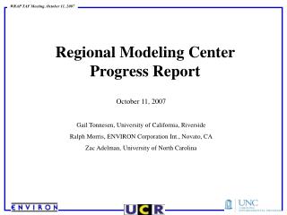
Potential Future Regional Modeling Center Cumulative Analysis. Ralph Morris ENVIRON International Corporation Novato, California rmorris@environcorp.com Workshop on Regional Emissions and Air Quality Modeling Studies Western Regional Air Partnership Denver, Colorado July 29, 2008.

E N D
Potential Future Regional Modeling Center Cumulative Analysis Ralph Morris ENVIRON International Corporation Novato, California rmorris@environcorp.com Workshop on Regional Emissions and Air Quality Modeling Studies Western Regional Air Partnership Denver, Colorado July 29, 2008
To discuss potential activities to be included in a 2009 Scope of Work (SoW) for the next generation of the WRAP Regional Modeling Center (RMC) One potential future RMC task could be to provide regional air quality modeling support to the air quality components of NEPA and PSD modeling activities: Ensures consistent approaches Uses latest inventories, meteorology and models Transparent assessments in the open Serves as a repository of databases Accounts for cumulative assessment across all potential new projects in western U.S. This work would be broken into a Core Effort that provides regional modeling support across western States and Optional Efforts to provide project-specific support as requested Purpose
Oil and Gas (O&G) development in the western states has grown substantially in recent years Under NEPA, new O&G development projects must disclose potential environment impacts due to the Project alone and Project plus all other new developments in the region (Cumulative Assessment) New sources also need to estimate their potential AQ and AQRV impacts under PSD permitting process NEPA and PSD not limited to O&G development projects Background
Jonah Infill Drilling Project EIS completed 2006 (Sublette County in Southwest Wyoming) AQ and AQRV analysis using AERMOD & CALPUFF Draft Supplemental EIS for Pinedale Anticline development project completed in 2007 AERMOD and CALPUFF used In 2005, elevated winter ozone measurements are recorded in Sublette County (repeated in 2006 and 2008) Pinedale Anticline SEIS performs ozone modeling assessment Final Pinedale Anticline SEIS released June 2008 showed exceedances of the 8-hour ozone NAAQS (0.075 ppm) Example Evolution of O&G EIS in SWWY
BLM Hiawatha and Moxa Arch O&G development projects in SWWY Modeling Protocol proposes AERMOD and CALPUFF (NRG, 2006) Need to address ozone due to high ozone measurements in Feb/Mar 2005/2006 CAMx model applied for just ozone using 36/12/4 km grid 4 km ozone impacts in SWWY Questions Regarding Adequacy of Emissions in SWWY Current-year WRAP Phase II O&G emissions deficient in VOC emissions (designed for regional haze modeling) Future-year Reasonable Foreseeable Development (RFD) scenarios from past EISs also deficient in VOCs VOCs not reported in RFD inventories as ozone modeling wasn’t performed Need to redo AERMOD, CALPUFF and CAMx ozone modeling w/ corrected inventories for Hiawatha and Moxa Arch O&G EISs Example Evolution of O&G EIS in SWWY
2007 BLM Continental Divide-Creston (CD-C) EIS in SWWY Propose to use CMAQ or CAMx for all far-field AQ and AQRV as well as for ozone (No CALPUFF) Detailed emissions updates for 2005 and 2006 in SWWY (O&G VOC emissions increase from 200 TPY from WRAP Phase II to >100,000 TPY) CMAQ/CAMx evaluation comparison and model selection Updated SWWY O&G emissions to be used in revised Hiawatha and Moxa Arch EIS modeling Drop CALPUFF and use CAMx for ozone as well as far-field AQ/AQRV Example Evolution of O&G EIS in SWWY
Much of emissions, meteorological and air quality regional modeling to support EIS and PSD needs is also applicable to information needed for 8-hour ozone and PM2.5 SIPs/TIPs and 2012 regional haze SIP checks. Regional 36/12 km modeling can be used to provide BCs to states for focused 12/4 km modeling to address 8-hour ozone and PM2.5 SIP attainment demonstration, including regional control strategies New 36/12 km base year and 2013 and 2018 year modeling can be used in the 2012 regional haze SIP check analyses Rural/remote areas and Class I areas can be analyzed down to 12/4 km resolution for impacts and regional control strategies across state, tribal, and federal lines Science updates of the future RMC can be implemented in EIS modeling Documentation and delivery of results through WRAP TSS Relationship with other future RMC Activities
Core Support for EIS/PSD and Other Regional Air Quality Management Periodic Updates of Base-Year and Future-Year Emissions Inventories – meets key need for emissions data management Update Project-Specific information as it becomes available Repository for emissions data and modeling files Base-Year 36/12 km MM5/WRF Meteorological Modeling Western US 12 km Domain SMOKE Emissions and CMAQ/CAMx AQ Modeling on 36/12 km domain for Base- and Future-Years Model Performance Evaluation Visibility and AQ Projections BCs for more local-scale 12/4 km domains Documentation & delivery of results through WRAP TSS RMC Support to EIS/PSD Modeling
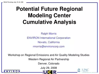
WRAP 36/12 km Modeling Domains • RMC would periodically update 36/12 km modeling and provide BCs to local-scale 12/4 modeling studies • EIS • PSD • NAAQS • Other?
Optional Support to EIS/PSD Studies Project-Specific Modeling Protocol 4 km MM5/WRF Meteorological Modeling MM5/WRF Data Processing to Project-Specific 12/4 km Domain SMOKE Emissions Modeling 12/4 km CMAQ/CAMx 12/4 km Base- and Future-Year Modeling Zero-Out or Source-Apportionment modeling to address project-specific and cumulative new source impacts Address Ambient Standards, PSD I and II, Visibility, Deposition, ANC, etc. Documentation of Results in Technical Support Documents (TSDs) and/or Documentation & delivery of results through WRAP TSS RMC Support to EIS/PSD Modeling
Additional Optional RMC Support to EIS/PSD Processing of MM5/12/4 km data for CALMET Processing of surface, upper-air and precipitation data for CALMET Processing of future-year project-specific and cumulative emissions for CALPUFF CALMET meteorological modeling or use of new MM5 translator to map MM5 data directly to CALPUFF inputs CALPUFF modeling of project-specific and cumulative sources Post-processing for Ambient Standards, PSD Increments, visibility, deposition and ANC Documentation in a TSD and/or Documentation & delivery of results through WRAP TSS RMC Support to EIS/PSD Modeling
EIS and PSD Modeling Efforts Continuous Support Needed New 35 µg/m3 24-h PM2.5 NAAQS (revised 2006) New Area Designations: November 2009 New SIPs: April 2012 Attainment Deadline: April 2015 New 0.075 ppm 8-Hour Ozone NAAQS (revised March 2008) New Area Designations: 2010 (2007-2009 data) New SIPs: 2013 Attainment Deadline: 2016 (Moderate) to 2030 (Extreme) Regional Haze 2012 SIP Check analyses Relationship with Regional AQ Planning Efforts
Potential 8-hour ozone nonattainment areas under the new 2008 0.075 (pink) NAAQS [and 0.070 ppm (pink+blue) NAAQS] 8-Hour Ozone NAAQS Current nonattainment areas under 1997 0.08 ppm 8-hour ozone NAAQS
2006 PM2.5 NAAQS PM2.5 NAAQS 1997 PM2.5 NAAQS
Questions Comments Discussion Next Generation of the WRAP Regional Modeling Center (RMC)