Download
1 / 11
120 likes | 355 Views
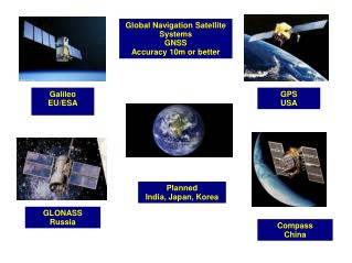
Global Navigation Satellite Systems GNSS Accuracy 10m or better. Galileo EU/ESA. GPS USA. Planned India, Japan, Korea. GLONASS Russia. Compass China. Space Based Augmentation Systems Improves GNSS accuracy to 3 metres. GNSS Errors.

E N D
Global Navigation Satellite Systems GNSS Accuracy 10m or better Galileo EU/ESA GPS USA Planned India, Japan, Korea GLONASS Russia Compass China
Space Based Augmentation Systems Improves GNSS accuracy to 3 metres
GNSS Errors Ionospheric & Tropospheric diffraction 10 + 1 metres Canyon Effect – 1 metre Part copied from http://www.kowoma.de/en/gps/errors.htm Timimg errors 4m – Rounding errors 1m Geometry up to 100m Orbits up to 5m
Ionospheric effects ± 5 metres Shifts in the satellite orbits ± 2.5 metres Clock errors of the satellites' clocks ± 2 metres Multipath effect ± 1 metre Tropospheric effects ± 0.5 metre Calculation & rounding errors ± 1 metre All adds up to +- 15m – 10m typically stated With EGNOS still +-3 to 5m according to this source However +- 1m considered realistic
R1 Ephemeris – Actual Position of the Satellite Time – determines how far away we are R1 Geometry locates us anywhere on the surface of a sphere
R2 R1 Ephemeris – Actual Position of the Satellite Time – determines how far away we are R1 Geometry locates us anywhere on the surface of a sphere Intersect 2 Spheres gives a ring
R2 R1 R3 Ephemeris – Actual Position of the Satellite Time – determines how far away we are R1 Geometry locates us anywhere on the surface of a sphere Intersect 2 Spheres gives a ring Intersect 3 Spheres gives 2 points 4 spheres gives a 3D position
CODE DIVISION MULITPLE ACCESS – CDMA SPREAD SPECTRUM GNSS DATA + TRANSMISSION SPREADING CODE CORRELATOR RECEPTION DATA OR PRN
Cold Start – Load The Almanac – where are the satellites Warm start – get satellite data and extract Ephemeris (position) and time Calculate UTC Do Geometry and get a 3D fix Use SBAS to correct Fix Use Regression to get better accuracy ASSISTED GPS – this is a technique whereby another source of location data is used to enable the device to start seeking the most apprpriate satellites. E.G. CELL-ID, dead reckoning or just memeory
Space Based Augmentation Systems Improves GNSS accuracy to 3 metres
INTRODUCTION TO DATA OVER GSM ANALOGUE – e.g V22 etc SHORT MESSAGE SERVICE – SMS GPRS BASIC SMS COMMANDS AT+CMGS=”+447967123456” > ENTER TEXT CONTROL Z AT+CMGR=NN AT+CMGD=NN AT+CMGW=”+44796123456” > ENTER TEXT CONTROL Z AT+CMSS = NN