Spatial Data Management
Spatial Data Management. -The St.Vincent and the Grenadines Chapter Author: Dornet Hull (Ms) GIS Officer Ministry of Housing Informal Human Settlement Land ,Surveys and Physical Planning. BUSINESS. VACATION. HOME. Spatial Data Management.

Spatial Data Management
E N D
Presentation Transcript
Spatial Data Management -The St.Vincent and the Grenadines Chapter Author: Dornet Hull (Ms) GIS Officer Ministry of Housing Informal Human Settlement Land ,Surveys and Physical Planning
Spatial Data Management -The St.Vincent and the Grenadines Chapter Author: Dornet Hull (Ms) GIS Officer Ministry of Housing Informal Human Settlement Land ,Surveys and Physical Planning
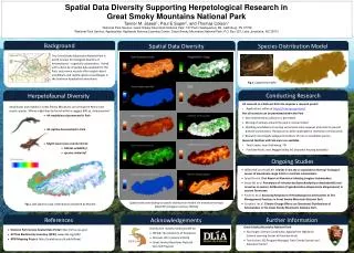
Background The Issue • The diversification of the economy since changes in the Banana industry dictated a need for careful land management. • Alternative strategies for land management, ownership and usage needed careful documentation along with the presentation of information and scenarios .
NALIMP National Land Information Project (NALIMP) Aim: to develop and operationalize a National Land Information System/Geographical Information System (LIS/GIS)
GIS UNIT Dornet Hull – GIS Officer Dwane Allen – GIS Technician Daven Smith – GIS Assistant Sean Daniel – GIS Assistant Sylbert Frederick – GIS Assistant
Challenges • Data Acquisition • Data Sharing • Lack of a GIS policy • Software
Opportunities • GeoNode : • an open source platform that facilitates the creation, sharing, and collaborative use of geospatial data. • The project seeks to surpass existing spatial data infrastructure solutions by integrating robust social and cartographic tools. • http://geonode.gov.vc/
Opportunities • Participatory Three Dimensional Modelling (P3DM ) • Sustainable Grenadines (SusGren) in collaboration with the Technical Centre for Agricultural and Rural Cooperation (CTA) and The Nature Conservancy (TNC).
Opportunities • Regional Disaster Vulnerability Reduction Project (RDVRP) • Aim: measurably reducing vulnerability to natural hazards and climate change impacts in the Eastern Caribbean sub-region.
by return period: 1 in 10 year storm by return period: 1 in 25 year storm
The Way Forward • Training : Basic and Advance • Creation of a National Spatial Data Centre
Contact:Physical Planning Unit Sharpe’s Street Kingstown St.Vincent 784-4571588 Email: ppuhilp@yahoo.com