Download
1 / 33
330 likes | 339 Views
This presentation discusses the Mississagua Lake levels and the priorities of the Coalition for Equitable Water Flow (CEWF) in 2015. It highlights the major infrastructure funding announcement by the Government of Canada for the TSW infrastructure and provides information on the TSW waterway, reservoirs, flow-through lakes, and water flow constraints. The presentation also includes statistics on Mississagua Lake levels and a discussion on preferred water level studies.

E N D
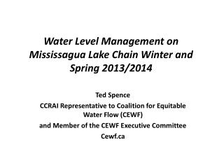
Mississagua Lake Levels and the 2015 Priorities of the Coalition for Equitable Water Flow (CEWF) Presentation to the Cavendish Community Ratepayers’ Association Inc. - CCRAI June 27, 2015 Ted Spence – CEWF Chair cewf.ca
Major Infrastructure Funding Announcement - June 19, 2015 • The Government of Canada has announced a five year $285 million capital improvement program for the TSW infrastructure. • Five Projects in the reservoirs (Haliburton Sector) are included - Rehabilitation of the Mississagua Lake Dam ($2.8M), - Rehabilitation of the Coboconk Dam ($1.2M), - Rehabilitation of the Horseshoe Lake Dam ($700k) - Replacement of the Kennisis Lake Dam ($1.4M) supplementary funding to go with the $3.5M previously announced. - Funding for concrete rehabilitation at various sites ($10.6M) • A major reconstruction of Dam #1 at Trenton ($25.3M) along with mechanization of several canal dams will mean significant improvements to the Water management capacity of the whole system.
Reminder of a Few Facts about the TSW Today Waterway Stretches 386 kms from Georgian Bay to Lake Ontario and includes 45 locks from #1 Trenton to #45 Port Severn Flows west to Lake Simcoe and on to Georgian Bay, and Southeast to Lake Ontario with the divide in the area of Kirkfield just west of Balsam Lake Eastern section includes the Kawartha Lakes and the Trent River system as well as 41 Reservoirs and more than 20 Flow-Through lakes (RAFT Lakes) 4
Reservoir & Flow-Through (RAFT) Lakes • In the “Haliburton Sector” (Haliburton County and Northern Peterborough County) there are 35 reservoirs - 17 in the Gull River system outlet to Balsam Lake, 13 in the Burnt River System outlet to Cameron Lake, and 5 in the central area including the Mississagua chain of lakes, Anstruther , Eels, Jack’s and Crystal lakes. There are also 6 reservoirs in the Crowe River basin. • The reservoir systems are very complex to manage with seasonal water level changes of up to more than 10 feet (3.4 m) combined with severe flow constraints at some points (eg Minden) • There are also challenges to maintaining navigable water levels on connecting rivers and flow-through lakes in the reservoir area (e.g. Shadow, Mountain, Maple) .
Kawartha Lakes Annual Flow(20% Gull R, 21% Burnt R, 28% Central Reservoirs, and 31% from the South)Source KLSA 2009
Kawartha Lakes Summertime FlowOver 90% of Summer Flow is from the ReservoirsSource KLSA 2009
Key Water-Flow & -Level Constraints • TSW priorities public safety (flood management and water supply) and canal navigation; • Minimum flow at Peterborough for water supply and sewage treatment; • Maintaining the Canal Regulations draught limits is understood to govern the drawdown from the reservoirs; • It is also understood that leakage through dam #1 in Trenton exceeds all other constraints for extended periods. • MNR Fisheries constraints in spring (walleye) and fall (lake trout) based on limited data for many lakes; • The reservoirs are not a flood control system particularly in late spring!
Mississagua Lake LevelsA Typical Reservoir LakeDam Height with 8 Logs 2.44 m, Winter set 2 logs, Avg Ann Fluct 1.35 m.
2014 – Water Levels • Very heavy snowpack in southern reservoir area in Winter 2014, • rapid runoff in April, • logs removed to avoid flooding with ice, • dry May and reservoirs filled slowly through May and June. • A wet summer • Northern reservoirs full by end of May … but water levels continued to rise on several lakes through June putting Loon breeding at risk • June was extraordinarily wet in Haliburton: 241mm compared to average of 81 mm; June 30th had a single day with 77 mm – flooding. • Many lakes remained at above average levels through July & August • Drawdown delayed by about a month • Wet fall resulted in late minimum levels on many lakes possibly impacting trout spawn. 14
Weather - Spring 2015 • Winter snowpack was low in water content throughout the reservoir areas. • Extreme cold and no winter melt led to record low lake levels in many reservoirs in February and March. • Haliburton spring rainfall - near normal • April near normal 73mm vs 76 mm normal • May 64 mm vs 81 mm normal • Peterborough rainfall- very dry except for extreme local events • April very dry except for 40 mm on one day the 20th , total for month 72 mm vs normal of 68 mm. • May very dry except for 35 mm on 30th and 31st, total 52 mm vs normal of 68 mm. • Southern reservoirs way behind Northern reservoirs in filling. • Mississagua only filled because of overflow from Anstruther.
Crystal Lake Water Levels 2015June 24, 2015 40 cms below full
Preferred Water Level Studies The Coalition is promoting the concept of a lake-specific “Preferred Water Level Range” (PWL) during the principal navigation season from mid-May to mid-September based on constraint data that are unique to each lake - as provided for in the AECOM Study. • 12 of 35 CEWF Reservoirs now have a PWL document. • CEWF believes that the identification PWL ranges will help the TSW understand the impact of their operations on local waterfront property ownerson the reservoir lakes • The current ‘equal percentage draw-down’ approach used by the TSW would remain the underlying water management operating principle at the start of the season in most cases. • Impact of PWL is likely to be in wet years with no water shortages.
Status of PWL Project and TSW TSW acknowledges they do not have good impact data for most reservoir lakes. What happens when lake goes too high or too low? PWL can not reduce total storage available when all reservoirs are full. PWL should not override fisheries constraints on trout lakes in fall. But TSW has responded to CEWF interventions in past when action does not conflict with Canal needs. TSW has referred this initiative to the WMAC but WMAC inactive now. 21
Draft 1 Mississagua Lake Preferred Water Levels – 30” of water in McGinniss Cut -
What is the Coalition for Equitable Water Flow (CEWF)? • The Coalition is a Volunteer Organization • Formed in 2006 to input to Panel on the Future of the Trent Severn Waterway in 2007 • Represents interests of 35,000+ shoreline property owners in “Haliburton Sector” of Trent watershed with regard to water management issues • Includes “Reservoir” and “Flow-Through” (RaFT) lakes and our 32 Member Lake Associations represent over 90% of the TSW’s reservoir lake storage capacity • Sub-watersheds included: • Gull, Burnt & Mississagua rivers plus Nogies, Eels & Jacks creeks • CCRAI is a member of CEWF 23
Member Lake Associations Represents 90% of Reservoir Capacity: 6% no known LA • Anstruther • Big Bob (South) • Canning • Cavendish Ratepayers (Mississagua, Catchacoma et al) • Crystal • Drag & Spruce • Eels • Esson • Fortescue • Glamor • Gull • Haliburton • Halls & Hawk (Big and Little) • Horseshoe • Jack’s • Kashagawigamog • Kennisis • Koshlong • Kushog • Little Glamor • Loon • Maple/Beech/Cameron • Miskwabi • Moore • Mountain • Percy • Redstone • Salerno/Devil’s • Soyers • Twelve Mile/Little Boshkung • White
CEWF Objectives • To promote an Integrated Approach to Water Management at the Watershed Level that will improve water conservation while recognizing the environmental, public safety, social and socioeconomic constraints of managing the water resource. • To maintain dialogue with TSW management to ensure improved understanding of local issues and management of water levels and flows in the RaFT lakes (includes Preferred Water Levels project). • To promote shared information and understanding of water management issues and practices watershed wide across the Canal lakes, and the RaFT lakes. • To promote approaches to ensure safe navigation, access to waterfront property, economic sustainability and the avoidance of negative environmental and economic impacts for residents on the RaFT lakes.
2015 – CEWF Priorities Continue advocating for an Integrated Approach to Water Management at the Watershed Level. Continue to work with TSW Management on behalf of the RaFT Lakes. Meet with new Municipal Councils in Haliburton and Northern Peterborough Counties. Continue to work closely with member lake associations to promote understanding of water management issues. 26
2015 – CEWF and TSW Management • CEWF will continue too work with TSW management with a focus on: • Greater understanding of RaFT lake issues including preferred water levels, fisheries and other environmental constraints, winter set levels, and flood management issues and constraints. • Encouraging TSW to act on the recent AECOM Study recommendations with specific reference to the acquisition of improved forecasting models. • Encourage TSW to work with municipalities and Ontario to provide a greater information base for effective water management in flood situations with the objective of improving public safety and minimizing damage costs. • Encouraging TSW to reactivate the TSW Water Management Advisory Council. • Urging the public release of the results of the numerous dam safety reviews that have now been undertaken across the TSW system. • Ensuring opportunities for public and municipal input on TSW capital project planning. 27
2015 – CEWF and Municipalities and the Province • CEWF intends to meet with the new municipal councils in Haliburton and northern Peterborough Counties • To expand understanding of the complexity of watershed wide water management issues and seek support for more integrated planning. • To initiate a conversation on the value of establishing a single entity to speak on watershed wide water management related issues for the entire RaFT lakes area not currently represented by a Conservation Authority. • CEWF will attempt to engage the Province of Ontario to work with TSW and take action under the MOU with Parks Canada on Integrated Watershed Planning across the entire Trent Watershed, which is the largest watershed in Southern Ontario. 28
CEWF Believes We Need Integrated Water Management Planning at the Watershed Level We need federal, provincial and municipal collaboration under the 2011 Memorandum of Understanding. Who speaks for the reservoir area? (CEWF will be raising this issue with municipalities). What is the role of Conservation Authorities? In Peterborough County there is little focus on the reservoirs. 29
Six Conservation Authorities in the Trent Severn Watersheds but No CA Coverage for Most of the Reservoir Lakes Areas
The CEWF Website Cewf.ca Your gateway to the latest information and data from TSW in a changing communications environment. Sign up for email updates and notices!!
Cewf.caLinks to TSW and CEWF News, TSW Water Levels, and Level forecasts
CEWF and CCRAI Discussion? Questions? Follow us throughout the year at www.cewf.ca • Water level forecasts are posted weekly during drawdown 33