Download
1 / 23
230 likes | 402 Views
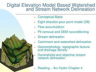
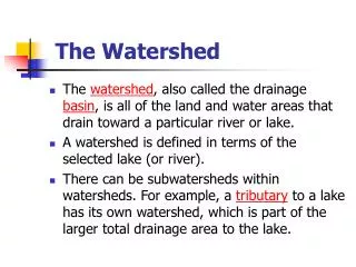
Watershed Boundary Dataset (WBD) –California Experience CALGIS Lorri Peltz-Lewis, WBD State Coordinator CA & NV. Watershed Boundary Delineation (WBD). 1978 USGS 1:250,000 National Hydrologic Unit Code (HUC) Maps – Watersheds interagency standard 8-digit cataloging units.

E N D
Watershed Boundary Dataset (WBD) –California Experience CALGIS Lorri Peltz-Lewis, WBD State Coordinator CA & NV
Watershed Boundary Delineation (WBD) • 1978 USGS 1:250,000 National Hydrologic Unit Code (HUC) Maps – • Watersheds interagency standard • 8-digit cataloging units
Watershed Boundary Delineation (WBD) • 1995 CDF - CalWater Map 1.1 • DWR – CalWater 2.0 & 2.2 • Mixed watershed & administrative boundaries
Watershed Boundary Delineation (WBD) WBD NRCS: http://www.ncgc.nrcs.usda.gov/products/datasets/watershed/ Calwater : http://cain.ice.ucdavis.edu/calwater/Interagency Watershed Mapping Committee (IWMC or “CalWater”) – MOU
Watershed Boundary Delineation (WBD) • Interagency Standard • Delineation of Hydrologic Unit Boundaries • FGDC Sponsorship • Spatial Water Data Committee: • NRCS • USGS • USFS • BLM • COE • FEMA • NOAA • NWS
Watershed Boundary Delineation (WBD) • National Seamless Database • Key characteristics: • Nationally consistent seamless • Nested subdivisions • 5-15 Watersheds per Cataloging Unit • Boundaries based on 1:24,000-scale topographic maps • Hydrologically based, no political divisions • 12-digit (6th-level) Hydrologic Unit Codes • Formally established watershed names • Attribute standardized • Names from GNIS, hydrologic in nature • Structure supports hydrologic routing • CERTIFICATION METHOD
Watershed Boundary Delineation (WBD) Level 1 - Region – 2-digit HUC Level 2 - Subregion – 4-digit HUC Level 3 - Basin – 6-digit HUC (was "accounting unit") Level 4 - Subbasin – 8-digit HUC (was "cataloging unit") Level 5 - Watershed – 10-digit HUC (was 10-digit) Level 6 - Subwatershed – 12-digit HUC (was 12-digit) Local planning may extend the watershed hierarchy to Levels 7 (14-digit) and 8 (16-digit).
Watershed Boundary Delineation (WBD) Creation of WBD meeting National Standards – CA started in 2000 Workshop 1: Portland (May - June 2001) Workshop 2: Sacramento (December 2001) Workshop 3: Fresno (March 2002) Workshop 4: Shasta (June 2002) Workshop 5: Reno (November 2002) Workshop 6: San Bernardino (March 2003) Workshop 7: San Francisco Bay Area (August 2003)
Watershed Boundary Delineation (WBD) 2004 – Managers Reports – Funding Request 2005 – CalFed Funding Request – 1.6 M$$ 2006 – More Funding Requests – IWMC Presentations 2007 – EPA & CA State Water Resources Control Board 2008 – Completion & CERTIFICATION!!!
Watershed Boundary Delineation (WBD) 2007 Progress August October December March
Watershed Boundary Delineation (WBD) Review Procedure (FGDC Guidelines) & Status Certification Review Steps: State Coordinator submit completed Review Committee checks dataset (pass/fail) Problems fed back to state until dataset passes State makes corrections and resubmits dataset Dataset accepted and integrated Official release as National WBD
Watershed Boundary Delineation (WBD) Resolving Issues:
Watershed Boundary Delineation (WBD) Resolving Issues:
Watershed Boundary Delineation (WBD) Resolving Issues:
Watershed Boundary Delineation (WBD) • Deliverables: • 2008 Dec - Certified dataset • 2009 – Stewardship, coastal, Mexico, Calwater 3, vertical integration – harmonization - others • Releases through California Spatial Information Library (CASIL) – submitted MDB in December – status unknown • http://gis.ca.gov/ • Final certified through Geospatial Data Gateway. • http://datagateway.nrcs.usda.gov/ • Additional formats being discussed.
Watershed Boundary Delineation (WBD) NHD/WBD Stewardship Conference – next week! WBD Stewardship & Maintenance Issues 1 – No Post-Certification Stewardship Strategy 2 – Stewardship Roles and Responsibilities 3 – Update/Maintenance Workflow
Watershed Boundary Delineation (WBD) WBD Stewardship & Maintenance Issues (continued) 4 – Relationship between WBD and NHD being defined - stored in same GDB, supported jointly - phased in loading of WBD – start Spring 2009 - WBD integration into NHD w/ metadata - tool development - distribution – USGS/NHD main, NRCS secondary 5 – Delineations beyond 6th Level being determined - 7ths – 3,000 - 10,000 acres (DRAFT) - 8ths – 100 – 3,000 acres (DRAFT) - DRAFT at this time
Watershed Boundary Delineation (WBD) WBD Coastal Meeting – October 2008 1 – Remove shoreline from WBD – move it to NHD 2 – Move WBD to 3 nm offshore – drop “toe of shoreface” 3 – Consistent integration for bays, sounds, and estuaries – NOAA assessments, state legal defintions, head of land principle, state determines closure 4 – Pilot locations proposed – spring 2009 5 - coordination with NHD ongoing
Watershed Boundary Delineation (WBD) WBD Integration with Mexico 1 – met with Mexico representatives Nov 2008 2 – delineation methods defined by NRCS/USGS accepted 3 – integration started late Dec 2008
Watershed Boundary Delineation (WBD) • WBD Calwater 3 – IWMC taking on this effort • 1 – Integrate stewardship efforts • 2 – Develop best management practices from other states • 3 – Evaluate mapping/planning efforts within the state that may be impacted and coordinate with - Meeting March 4, 2009 • SWRCB – • Geospatial tools developed for CalWater – Water Rights, Upstream Area, etc. • 303d (Clean Water Act) assessments & beneficial use • State Board Strategic Plan – update & modernization • Basin plans using CalWater 2.2.1 • CalWater 2.2.1 codified water quality regulations • DWR – Detailed Analysis Units, Water Districts, Irrigation Districts, etc. • CALFIRE – Forest Practice Rules, Timber Harvest • Fish & Game – no one present • Others – Proposition 13 (Water Quality Improvement), Basin Planning (tributary rule), Local Community Involvement
Watershed Boundary Delineation (WBD) WBD – on going & future efforts - Nationally 1 – Vertical Integration issues – densification, old maps, changed hydrology (land use change, man made, catastrophic events, etc.)
Watershed Boundary Delineation (WBD) WBD – on going & future efforts - Nationally (continued) 2 – Indexing to NHD – - geometric pour point layer - indexing flow within WBD similar to NHD 3 – State/Local – - Dam integration - non-USGS gaging stations - diversions – critical & non-critical 4 – Update events - EPA TMDLs (done in 100K NHD) - etc.
Watershed Boundary Delineation (WBD) GET DATA – http://datagateway.nrcs.usda.gov/ Questions?