Download
1 / 18
180 likes | 223 Views
Explore the natural hazards, flood areas, and mitigation measures in Barbados. Discover the historical flood zones and works programs designed to combat flooding issues.

E N D
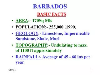
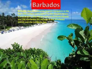
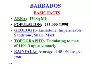
BARBADOS BASIC FACTS • AREA:- 170Sq Mls • POPULATION:- 255,000 (1990) • GEOLOGY:- Limestone, Impermeable Sandstone, Shale, Marl • TOPOGRAPHY:- Undulating to max. of 1100 ft approximately • RAINFALL:- Average of 45 - 60 ins per year
NATURAL HAZARDS • HURRICANE:- Threatens all exposed structures including houses, commercial and public buildings, telecommunications towers, utilities, agriculture. • STORM SURGE: Hurricane related. Threatens most of the coastline especially the economically vital tourism plant and some critical lifeline facilities.
NATURAL HAZARDS • TSUNAMI:- A threat to most of the coastal area outlined for Storm Surge. • LAND BORNE FLOODING:- Occurs in several areas across the island. • LANDSLIDES:- Concentrated mainly in the Scotland District. Covers 1/7 of the island. Consists mainly of impermeable sandstone, shale, marl.
HAZARD / NATURAL REOURCES STUDIES • SCOTLAND DISTRICT ( 6 STUDIES 1946 - 97) • STORM WATER DRAINAGE STUDIES (73, 94) • ENVIRONMENTAL AND NATURAL RESOURCES STUDY/PLAN (1998) • WATER LEVELS FOR BARBADOS (1994) • JAN 99 S/DIS’T DEVELOPMENT PROJECT • S/D SOIL CONSERVATION/ DEV STUDY 99 • DRAFT NATIONAL PHYSICAL DEV. PLAN (FEB 98)
DRAINAGE STUDY • Collect and analyse Data; (rainfall, runoff, flooding and land use for the period 1973- 93 • Locate and study all flood prone sites within the study area and recommend practical solutions and effective flood control measures • Develop a Works Programme comprising the least cost design • Carry out an evaluation and assessment of the institutional requirements for O & M of present and futuredrainage works in B’dos
SOME ELEMENTS EXAMINED • Confirmation of Drainage boundariesusing; (topographic mapping, field reconnaissance, and air photos) • Determination of drainage characteristics; (area, length, topographic rise, slope, of impervious area, runoff coefficient). • Peak Flows at ; Culvert and Bridge locations were estimated and compared to expected flows to assess the flood potential. 2, 5, 10, 20, 25, 50, 100 year events were estimated
HISTORICAL FLOOD AREAS • PRESCOT LAND/CONSTITUTION RIVER - St Michael • GRAME HALL - Christ Church • SPEIGHTSTOWN - St Peter • AQUATIC GAP - Christ Church • HOLETOWN - St James • BAYLAND - St Michael • WOTTON - Christ Church • GIBBES - St Peter
FLOOD PLAIN AREAS • SPEIGHTSTOWN: From outlet to up stream of Round The Town bridge • HOLETOWN: From outlet to easterly limits of Jamestown Park • CONSTITUTION RIVER: From Duncan O’Neal bridge to Bridge Road • WESTON: From outlet upstream for 190 m
CHARACTERISATION OF FLOOD AREAS • MAJOR FLOOD HAZARD AREAS: Generally located where significant economic losses could occur. Has large watershed areas, poses risks to life because of higher peak flows, higher runoff velocities and higher potential depth of flooding.
CHARACTERISATION OF FLOOD AREAS • NUISANCE FLOOD HAZARD AREAS: Associated with smaller watersheds, shallower depths of flooding and reduced potential for injuries, loss of life and economic losses
WORKS PROGRAMME STRUCTURAL MEASURES CONSIDERED • Construction of drainage channels • Use of reservoirs and quarries to control flood peaks • Construction of dykes and or upgrading of bridges, culverts, and other drainage infrastructure
WORKS PROGRAMME NON STRUCTURAL MEASURES • Revisions to legislation for mitigation of flood losses • Control of development in flood prone areas • Encourage alternative landuse and agricultural practices which promote flood mitigation
WATER LEVELS FOR BARBADOS (1994) • RELATIVE SEA LEVEL RISE • TIDAL WATER LEVEL CHANGES • METEOROLOGICAL WATER LEVEL CHANGES • WAVE INDUCED WATER LEVEL CHANGES • TSUNAMI • DESIGN CRITERIA
TERMS OF REFERENCE • Determine engineering methods of protecting, increasing and or stabalising the size of beaches along the west and south coasts • Prepare land use planning recommendations for the south and west coastal zones, on a stretch by stretch basis, based on the need to preserve and enhance the coastal resource within a national economic context
OBJECTIVES • Determination of the normal and extreme levels of the astronomic tidal component • Analysis of any surge events that were present in the existing recorded tidal data • Examination of the wind and barometric components of hurricane related surge at several locations
OBJECTIVES (cont’d) • Analysis of the wave-induced set-up and run-up, giving consideration to different shoreline, beach and structure characteristics at or near the shoreline • Quantification of the most up to date information on long-term sea level change
SCOTLAND DISTRICT STUDIES • Geological Investigations of Ground Water Resources 46 • S/D Development Study 79 • Geology&Mineral Resource Assessment 82 • S/D Soil Conservation Project 83 -87 • Water Resources Management & Water Loss Study 96 • Field Guide to the Sub-Quanternary of B’dos 97
POLICIES & PROGRAMMES • Prioritising of occupied spots for relocation of houses (Priority 1, 2, 3) • Down grading of specific roads in Priority 1 areas to maintain for agricultural purposes only • Consolidation and stabalisation of highways • Identification and redirection of streams • Reforestation of areas which held relocated houses