Download
1 / 21
210 likes | 237 Views
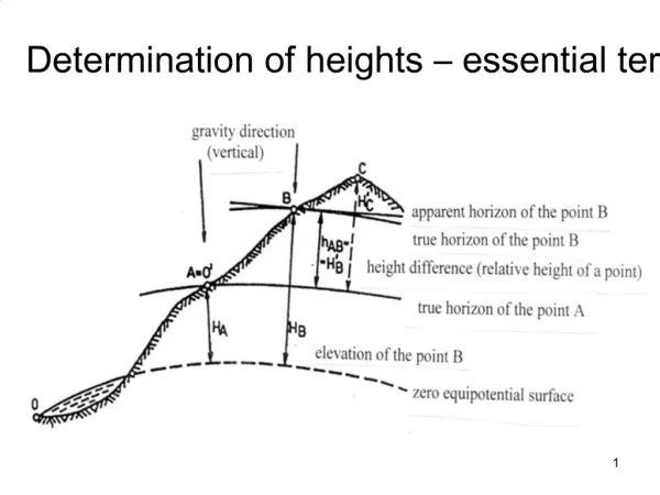
Explore methods to obtain heights accurately, evaluate NGS guidelines, and utilize modern GPS/GNSS technology for precise measurements.

E N D
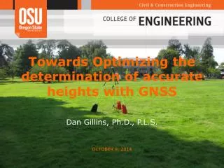
Towards optimizing the determination of accurate heights with GNSS • Dan Gillins, Ph.D., P.L.S. • and Michael Eddy, Ph.D. student April 14, 2015
Research Objectives • Develop reliable methods for obtaining heights to +/- 2 cm at 95% confidence • Evaluate current NGS guidelines for determining accurate ellipsoid (NGS 58, 1997) and orthometric (NGS 59, 2008) heights using • modern GPS/GNSS equipment • GEOID12A • Improved satellite orbit modeling • Improved antennas • Investigate other emerging/emerged technologies for optimizing the determination of accurate heights • GPS+GLONASS • OPUS-S, OPUS-RS, OPUS Projects • Real time networks (RTNs)
Timeline, accomplishments, ongoing work Completed • Project started on September 1, 2014 • Began field survey on October 7, 2014 • Field Survey completed on November 7, 2014 • All data has been downloaded and organized for submission to NGS • Developed “ground truth” ellipsoid heights, described hereinafter Ongoing Currently comparing other solutions with the “ground truth” coordinates • OPUS-Projects, variety of different constraint types • According to network designs in NGS 58 (using TBC and LGO for baseline processing, STAR*NET for network processing) • OPUS-S • OPUS-RS • Oregon Real-Time GPS Network (ORGN)
Survey Campaign Survey designed so that network(s) could be developed and processed according to NGS 58/59 guidelines • Surround project area with NSRS stations at no more than 75 km spacing • CORS • HARN (CBN, FBN) • Primary base network (40 km) • 5 hour static occupations for 3 days • Significantly different satellite geometry for each session (i.e., different times of the day) • Secondary network (15 km) • 0.5 - 1 hour static occupations for 2 days • Significantly different satellite geometry for each session • Local network (7 – 10 km) • 30 minute static occupations for 2 days • Significantly different satellite geometry for each session • Tie in benchmarks with published elevations at 20 km spacing or less
Survey Statistics • 18 passive stations in the Willamette Valley, Oregon • 4 FBN stations • 17 stations with leveled heights (2nd Order or better) • 7 were used to develop GEOID12A • 7 B-stability (steel rod set to refusal) • Collected static GPS+GLONASS data • 15 total days of surveying • All sessions logged 10+ hours of static data • 6 receivers (Leica GS14) on fixed-height tripods w/ sandbags • Every station occupied at least 4 times, every baseline observed at least twice (10 hours) • Simultaneously logged real-time data from the ORGN to the data collectors • Logged every epoch of real-time data (1-second rate) • Typical schedule: • Day 1: ORGN RTN correctors (GPS-only) • Day 2: RTK from single base (GPS-only) • Day 3: RTK from single base (GPS+GLONASS) • Day 4: Repeat of one of the first 3
Finding the "ground truth" coordinates • Need highly accurate coordinates on each station in order to compare techniques for optimizing the determination of heights • Two methods attempted and compared • Process all 10 hour GPS data in OPUS-Projects; constrain to the “best” CORS • “Best” CORS in only Oregon • “Best” CORS in Oregon + distant CORS • Follow NGS 58 and 59 guidelines, but process 5 hour baselines for entire network; constrain to CORV
OPUS-Projects Processing - User defined network CORS CORS OPUS Projects Technical Guide states to designate 1 “hub” within 100 km of all marks in the project. Hub is connected to each project station (passive mark) for every session. Connect this hub to multiple distant CORS (24 hour baselines). Constrain the CORS and leave the hub free. Baselines from hub to project stations (passive marks) ensure mutual visibility of the satellites Long baselines from hub to CORS improves tropo correction estimates Multiple CORS tie the network to the NSRS 24hr Hub 24hr CORS >2hr >2hr 24hr CORS
Selecting "Best" CORS • Selection made by viewing NGS short-term time series of each active station • Ensure the daily published position is consistently close to the IGS08 position (i.e., red line)
First OPUS-Projects “Ground Truth” Network • Constrained to CORS with daily coordinates consistent with IGS08 published position. Central hub (CORV) was free. • Resulting solution for the ellipsoid height at CORV matched its published position on the NGS short-term time series plot (to the mm) CORV
Second OPUS-Projects “Ground Truth” Network • For a second network, added longer baselines to distant CORS that were consistent with published IGS08 position • Resulting ellipsoid heights changed by no more than 0.003 m at all stations. Most changes were only ± 0.001 m
TBC/STAR*NET Network Processing for "Ground Truth" • Baselines processed in TBC; network processed in STAR*NET • Followed NGS 58/59 guidelines, but only processed 5 hour-duration baselines • All baselines less than 40 km • Every baseline observed twice in the adjustment —once in a morning and once in an afternoon, agree within ± 2 cm • Free network adjustment constrained to the published IGS08 position of CORV at mean epoch of survey (IGS08(2005) Epoch 2014.8). This published ellipsoid height at CORV matches the ellipsoid height derived from the OPUS-Projects processing (to the mm)
TBC/STAR*NET Network Plot CORV Vertical: average ellipsoid height at all stations: ±1.4 cm at 95% confidence Horizontal: average Semi-major ellipse length at all stations: ±0.4 cm at 95% confidence
Comparison of "Ground Truth" Coordinates Ellipsoid heights from first OPUS-Projects Network minus TBC/STAR*NET network • Differences ranged from -0.011 to 0.009 meters, centered about zero
OPUS-S and OPUS-RS • With high confidence in the “ground truth” coordinates, we have now begun investigating other technologies. • Using TEQC, divided 10+ hour RINEX data on all stations into varying observation durations (i.e., 10, 7, 5, 4, 2, and 1 hour files; 40 and 20 min files) • Submitted all decimated files to OPUS-Static and OPUS-RS • Forced OPUS to only use CORS with daily coordinates consistent with IGS published positions • Computed residuals in ellipsoid height from each individual OPUS-S/OPUS-RS solution with the “ground truth” height from the TBC/STAR*NET network
Accuracy of OPUS-S/OPUS-RS OPUS-S OPUS-RS
Oregon Real-Time GPS Network (ORGN) • Real-time GPS-only network data was collected from the ORGN at a 1 sec. epoch rate • Aggregated the data into 5 sec., 30 sec., and 1, 3, 5, 7, 10, and 15 minute observations • Randomly selected a start time and then combined continuous, fixed epochs of data from these start time • Repeated 50 times for each observation duration and at each station in the network • Used the covariance matrix of each epoch of data to compute a weighted observation
Conclusions and Future Work • It is possible to measure ellipsoid heights to ± 2 cm at 95% confidence by submitting a 4 hour data file to OPUS-S. This requires careful selection of CORS. • Ellipsoid heights can be measured to ± 5.0 cm at 95% confidence after only a 60 second observation in the Oregon Real-Time GPS Network. This value only improves to ±4.3 cm after a 10 minute observation. • Future work: • Evaluate real-time kinematic solutions from a single base in the ORGN. Single baseline data is available for GPS and GPS+GLONASS observations. • Investigate network post-processing of RTN/RTK baselines constrained to 4-hour OPUS-S solutions on a few stations in the network • Investigate accuracy of shorter-duration observations processed in OPUS-Projects
Acknowledgements • Many thanks to NGS for funding this study • Thanks to Mark Armstrong, NW NGS advisor • Thanks to ODOT-Geometronics for sharing advice and equipment • Thanks to David Evans & Associates and Leica for supplying us with the GS14 GNSS sensors and software • Thanks to my students: Darren Kerr, Michael Eddy, Marian Jamieson, Tyler Wall, and Nathan Jones