Download
1 / 26
260 likes | 282 Views
Join us for a public hearing on the S.R.28 Road Reconstruction project in Clinton County. Learn about the purpose, format, and how to participate. Visit our sign-in table and submit written public comments. Project resources available online.

E N D
S.R. 28 Road Reconstruction in Clinton County Thursday, September 26, 2019 6 p.m.
Welcome • Purpose of public hearing • Format • Visit our sign-in table • Informational handouts • Participate during public comment session • Submit written public comments • Project display area
S.R. 28 Road Reconstruction in Clinton County • Sign-in at attendance table to be added to project mailing list • Public hearing notice published in Frankfort Times 9/11 and 9/18 • Mailed notification to known property owners within project area • Announcement of this meeting was posted to INDOT website. A media release was also issued • A copy of presentation and project documentation are available for review online via INDOT website • INDOT Project Team • INDOT Crawfordsville District • Project Management • Public Involvement • Communications • Design/Engineering • Environmental Analysis • Real Estate • Recognition of elected and local public officials
Project Stakeholders • Indiana Department of Transportation • Federal Highway Administration • City of Frankfort • Clinton County • Elected & local officials • Residents and citizens • Commuters • Businesses • Emergency services • Schools • Churches • Community organizations
How a Project Becomes a Project INDOT - Transportation agency for State of Indiana Six Districts – Central Office is located in Indianapolis Project Selection • Prioritize needs • Call for Projects • Program projects • 4 Year project listing – Statewide Transportation Improvement Program • Project listing can be amended based on needs Development / Pre-Construction • Requests for – Information, Qualifications, Proposals (RFI, RFQ, RFP) • Consultant team selection • Engineering • Environmental Analysis • Cultural Resource Evaluation • Public Involvement / Community Outreach & Engagement • Design (roadway, bridge) • Utilities Coordination • Real Estate Acquisition – appraising, buying, relocation Project Delivery / Construction • Project letting – contractor bidding process • Construction, Maintenance, Operations
Project Development Public hearing during environmental analysis phase 2019 Communicate project decision late 2019 / early 2020 Public Involvement:
Environmental Consideration National Environmental Policy Act (NEPA) • Requires INDOT to analyze and evaluate the impacts of a proposed project to the natural and socio-economic environments • NEPA is a decision-making process • Purpose and Need • Develop & Screen Alternatives • Preferred Alternative – determine a course of action • Impacts are analyzed, evaluated and described in an environmental document • What are the impacts this project might have on the community? • How can impacts be avoided? • Can impacts be minimized? • Mitigation for impacts? • Draft environmental document(s) released for public involvement August 2019 • Available for review via public repositories and online
Types of items evaluated • Right-of-way • Streams, Wetlands, and Other Waters • Floodplains • Endangered Species • Farmland • Cultural Resources (Historic/Archaeological) • Parks and Recreational Lands (Trails) • Air Quality • Community Impacts • Public Involvement
Environmental Analysis & Public Involvement • Notice of Entry for Survey • Letters were mailed to properties within general area adjacent to the public right-of-way • Section 106 of National Historic Preservation Act – 2018 thru 2019 • Take into account proposal’s impact to historic & archaeological properties • Public invited to participate • Consulting Parties Meeting scheduled 11/1/18 • INDOT, FHWA and design consultant attended • Invitations sent to identified local consulting parties, none attended the meeting • Public notice issued with 30-day comment period • Frankfort Times on 2/20/19 • “Adverse Effect Finding” finding issued by the Federal Highway Administration (FHWA) • Draft environmental documents released for public involvement – August 2019 • Available for review via public repositories and online
Project Resources • INDOT Crawfordsville District Office 41 West 300 North, Crawfordsville, IN 47933 • http://www.in.gov/indot/2701.htm • Planning, Project Development/Delivery, Construction, Maintenance for West Central Indiana • Frankfort Community Public Library 208 West Clinton Street, Frankfort, IN 46041 • Phone: (765) 654-8746 • INDOT Office of Public Involvement 100 North Senate Avenue, Room N642, Indianapolis, IN 46204 • Phone: (317) 232-6601 • rclark@indot.in.gov Transportation Services Call Center Provides citizen and business customers witha single point-of-contact to request transportation services, obtain information, or provide feedbackthrough multiple channels of communications. 855-463-6848 • INDOT4U.com • INDOT@indot.in.gov
S.R. 28 Road Reconstruction – Project Limits • Approximately from intersection of S.R. 28 and C.R. 200 West, proceeding east along S.R. 28 to Hoke Avenue • Project length is 2.4 miles
S.R. 28 Road Reconstruction • Resurface S.R. 28 from C.R. 200 West to Blinn St. • Reconstruct S.R. 28 from Blinn Street eastward to Hoke Avenue • Add right turn lane from (WB) S.R. 28 to (NB) Jackson Street • Reconstruct storm-water system, the sidewalks on the south side of S.R. 28 and replacing the sidewalk on the north side of S.R. 28 with a shared used path
Purpose and Need • Purpose • Address deteriorated pavement condition • Improve safety within the corridor by adding turn lanes at Jackson and Clay intersections • Improve pedestrian and bicycle infrastructure with ADA compliant facilities • Emphasize ADA compliance due to proximity to downtown commercial district, city office building, Ivy Tech campus • Address condition of sidewalks • Bicycle accommodations do not exist along S.R. 28 • Need • Pavement condition is in need of repair / reconstruction • Concrete pavement installed in 1971 • Most recent asphalt overlay installed in 2015 • Curbs within the project limits are in poor condition • High number of vehicular accidents • S.R. 28 at Jackson Street • S.R. 28 at Clay Street
Alternatives Considered • Do Nothing/No Build • Perform routine maintenance only • Does not meet purpose and need • Alternative 1 • Replace the existing pavement with full depth pavement • Alternative 2 • Rubblize (reduce pavement into rubble) the existing concrete pavement from begin project to Doyal Street, full depth replace asphalt pavement east of Doyal Street. • Alternative 3 • Full depth patch, profile mill and place a functional overlay on the existing pavement from begin of project to Doyal Street. Full depth replace asphalt pavement east of Doyal Street • Alternative 4 (Preferred) • Mill & overlay to Blinn and replacement of existing pavement with full depth pavement east of Blinn
Preferred Alternative • Pavement replacement and/or overlay with intersection improvements and pedestrian improvements • Roadway • Mill and overlay from C.R. 200 W to Blinn Street • Full depth replacement from Blinn Street to Hoke Avenue • Dedicated left turn lanes at Clay Street • Right turn lane at west approach leg of S.R. 28 at Jackson Street • Replace existing curbs and gutters, existing storm sewer system, extend storm sewer east on Walnut Street past pavement replacement to Hoke Avenue, extending north to an unnamed tributary • Bridge Deck overlay at Prairie Creek with repairs to curb and sidewalk on bridge • Sidewalk • 5-foot wide concrete sidewalk will be reconstructed along the south side of S.R. 28 from Blinn Street to Hoke Avenue to replace the existing sidewalk that started at West St. • 8-foot wide asphalt/concrete multi-use path will be constructed on the north side of S.R. 28 from C.R. 200W to Hoke Ave. • Provide tree lawn between sidewalk/shared use path and curb – varying locations • Trees will be replaced in the Historic District east of Prairie Creek • New Rail crossing equipment
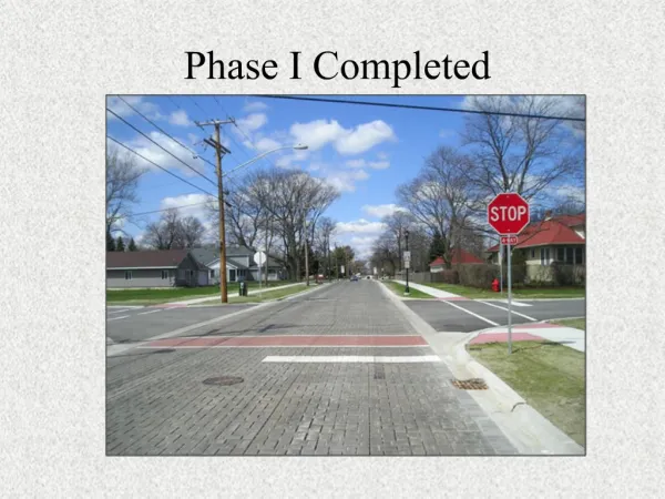
Existing Roadway • Failing Pavement • Poor Drainage • Curbs and Sidewalks in Disrepair
Typical Section • 12-ft wide travel lanes • New Curb & gutter • 8-ft wide multi-use path along the north side • 5-ft wide sidewalk along the south side • 2-way left turn lane from west end to Clay St. • Full depth pavement replacement east of Blinn • Improved Drainage - new inlets and storm sewers
Maintenance of Traffic • Maintain local access to all businesses and residences during construction by maintaining one lane of traffic in the westbound direction. • Traffic will be phased with construction west of Jackson Street in 2020 and construction east of Jackson Street in 2021. • While each of these sections is under construction the eastbound traffic will be detoured and the westbound will remain open to one lane of traffic.
Real Estate Acquisition Process • Right-of-way (ROW) • Permanent • Permanent ROW is land, once purchased by INDOT from the legal land owner, becomes ROW owned by INDOT • Approximately 0.3 acre required for improvement • Temporary • Temporary ROW is land required during the construction of a project and is used for the purposes of construction-related activity • INDOT pays legal land owner a fee for land use during construction • Approximately 0.4 acre required for improvement • Uniform Act of 1970 • All federal, state and local governments must comply • Requires an offer for just compensation • Acquisition Process • Appraisals • Review Appraisals • Negotiations
Project Schedule • Preliminary design, evaluate community and environmental impact 2019 • Public Hearing 2019 • Complete Environmental Analysis Phase 2019 • Real estate acquisition activities 2019-2020 • Appraising • Negotiations/buying • Utilities relocations 2019 - 2020 • Construction 2020 - 2021
Submit Public Comments • Submit public comments using the options described in first page ofinformation packet: • Public Comment Form • Via e-mail • Participate during public comment session following formal presentation • INDOT respectfully requests comments be submitted by Monday, October 14, 2019 • All comments submitted will become included in an official public hearings transcript and made part of the public record • Comments will be reviewed, evaluated and given full consideration duringdecision-making process
Next Steps • Public and project stakeholder input • Submit comments via options described on page 1 of information packet • INDOT review and evaluation • All comments given full consideration during decision-making process • Finalize/approve environmental document, complete project design • Communicate a decision • INDOT will notify project stakeholders of decision • Work through local media, social media outlets, paid legal notice • Make project documents accessible via repositories • Questions? Contact Public Involvement Team
Thank You • Please visit with INDOT project team following the presentation and public comment session • Project Open House • Project maps, displays, INDOT project team and informal Q & A • INDOT Crawfordsville District page http://www.in.gov/indot/2701.htm