Climate Classifications: Köppen
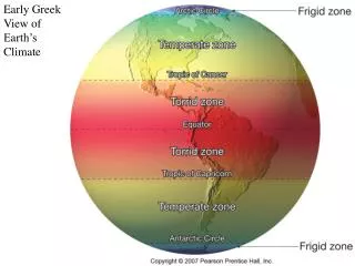
Climate Classifications: Köppen. Great Weather & Climate Site Check it out! METEOROLOGY - WEATHER AND CLIMATE: A CONDENSED PRIMER This Presents the Whole Picture!. Letter Definitions. Category, Name & Description. World Map of Climate Types.

Climate Classifications: Köppen
E N D
Presentation Transcript
Climate Classifications: Köppen Great Weather & Climate Site Check it out! METEOROLOGY - WEATHER AND CLIMATE: A CONDENSED PRIMER This Presents the Whole Picture!
World Map of Climate Types Check the World Climate Guide for specific locations
Tropical Rainforest (Af) • Characteristics • Constant high temperatures. • "Equal" day length. • Lowest annual temperature range of any climate. • Evenly distributed, heavy precipitation. • Much cloud cover and high humidity.
Af • Controlling Factors • High year-round insolation and precipitation of ITCZ. • Rising air along trade wind coasts. • mE air masses. • Geographic Distribution • Amazon Basin, • Congo River Basin, • East coast of Central America, • East coast and interior of Brazil, • East coast of Madagascar, • Malaysia, • Indonesia, • Philippines.
Af • Tropical broadleaf evergreen forests with vines (lianas), Bromelias, and epiphytes.
Tropical Monsoon Climate (Am) • Characteristics • Heavy high-sun rain; short low-sun drought. Highest temperature just before rainy period.
Am • Geographic Distribution • Coastal areas of southwest India, Sri Lanka, Bangladesh, Mynamar (Burma), • Southwestern Africa, • French Guiana, • northeast and southeast Brazil. • Controlling Factors • Summer onshore/winter offshore air movement related to shifting ITCZ or monsoon circulation. mE air masses during high-sun; stable mT or cT -> low-sun
Am • Tropical broadleaf evergreen rainforest with some deciduous trees and plants (dormant in the dry season)
Wet Dry Tropical Climate (Aw) • Characteristics • High-sun wet season, low sun dry periods. Rainfall less than monsoon. • Highest temperature ranges of low latitude wet climates.
Aw • Geographic Distribution • Northern and eastern India, interior Myanmar (Burma) and Indo-Chinese Peninsula; northern Australia; south central Africa; Ilanos of Venezuela, Campos of Brazil; • Western Central America; south Florida, and Caribbean Islands. • Controlling Factors • Shifting influence of high-sun ITCZ and low sun STH influence. High sun mE air masses; low-sun cT air masses
Aw • Tall to short continuous grasslands with scattered trees and galleria forests (along the banks of streams, often arching over the river to enclose it unless it is a very wide river.
Aw – galleria forest • Forest along the river transitioning to grassland as distance from the river bank increases.
Tropical Desert Climate (BWh) • Characteristics • Among the driest places on earth Mean annual temperature above 64.4o F (18oC) • Low relative humidity • Irregular and unreliable rainfall • Highest percentage of sunshine of any climate • Large diurnal temperature range • Highest daytime temperature of any climate • Annual precipitation less than half the annual potential evapotranspiration
BWh • Geographic Distribution • coastal Chile and Peru southern Argentina • southwest Africa • north Africa • Arabia, Iran • Pakistan, and western India; • Baja California and interior Mexico • Controlling Factors • Descending, diverging, circulation of subtropical highs Continentality linked often with rain shadow location. • cT air masses
BWh • Little or no vegetation • Types of desert • Reg- gravel and rock surface • Erg – sand dunes • Hamada – large expanses of unbroken rock Reg desert surface
BWh • Erg desert surface • Hamada desert surface
Tropical Steppe Climate (BSh) • Characteristics • Semiarid Annual rainfall distribution similar to nearest humid climate • Annual precipitation more than half, but less than annual potential evapotranspiration • Mean annual temperatures above 64.4oC (18oC)
BSh • Geographic Distribution • Peripheral to deserts especially in: • Australia • northern and southern Africa • southwest Asia • Argentina • western United States • Controlling Factors • Descending, diverging, circulation of subtropical highs Continentality linked often with rainshadow location.
BSh • Almost continuous short grass transitioning to bunch grass (bare ground between patches) and then transitioning to desert. It is subject to desertification: permanently transitioning from steppe to desert.
Midlatitude Desert Climate (BWk) • Characteristics • Aridity; low relative humidity. • Irregular rainfall. • High percentage of sunshine. • Larger temperature range than Tropical Desert. • More precipitation than Tropical Desert.
BWk • Geographic Distribution • inner Asia • (interior) western U.S. • Controlling Factors • Continentality often linked to rain shadow. • Subtropical high pressure or high pressure ridging. • cT air mass during summer. • mTs air masses; cP air masses especially on northern limits.
BWk • Semidesert and desert vegetation – Xerophytic plants.
Midlatitude Steppe (BSk) • Characteristics • Semiarid • Rainfall distribution similar to nearest humid climate • Temperatures vary with latitude, elevation, and continentality • Larger temperature range than Tropical Steppe • More precipitation than Tropical Steppe
BSk • Geographic Distribution • Inner Asia; • Western U.S. • Controlling Factors • Essentially the same as deserts; • Transitional to humid climates; • Leeward orographic influence (rainshadow)
BSk • Short grass with scattered small shrubs transitioning to BWk desert.
Humid Subtropical Climate (Cfa) • Characteristics • High humidity; summers like humid tropics. Frost with polar air masses in winter. • 25 to 100 in of precipitation, decreasing inland. • Monsoon influence in Asia.
Cfa • Geographic Distribution • Southeastern U.S. southeastern South America; • coastal southeast South Africa; • eastern Australia; • eastern Asia from northern India through south China to Japan. • Controlling Factors • East coast location between 20o and 40o N and S latitudes. Humid (mTu air masses) onshore air movement in summer. • Cyclonic storms in winter (cP air masses)
The ample precipitation and generally mild temperatures of the humid subtropical climate support a lush environment of temperate deciduous to temperate evergreen forests.
Mediterranean or Dry Summer Subtropical Climate (Csa, Csb) • Characteristics • Mild, moist winters, hot dry summers inland • Cool, often foggy coasts • High percentage of sunshine • High summer diurnal temperature range • Frost danger during winter
Csa; Csb • Geographic Distribution • Central California • central Chile • Mediterranean Sea borderlands • Iranian Highlands • Capetown area of South Africa • southwestern Australia • Controlling Factors • West coast location between 30o and 40o N and S latitude. • Alternating between Subtropical High in summer and Polar Front/Westerlies in winter. • Cyclonic precipitation during the winter. • Summer air masses: mTs, cT • Winter air masses: mT, mP, cP
Csa; Csb • Small, thick evergreen leaves of the sclerophyll forest combats water loss during the drought conditions of the dry summer found in the Mediterranean climate. The picture depicts a sclerophyll scrub forest in the subalpine zone in New Zealand.
Marine West Coast Climate (Cfb) • Characteristics • Mild winters, mild summers. • Low annual temperature range. • Heavy cloud cover; high humidity. • Frequent cyclonic storms, with prolonged rain, drizzle and fog.
Cfb • Geographic Distribution • Coastal Oregon, Washington, British Columbia, and southern Alaska • Southern Chile; interior South Africa • southeast Australia and New Zealand • northwest Europe • Controlling Factors • West coast location; year round influence of the Westerlies. • Warm ocean currents along some coasts. • Windward orographic influence in North America. • Located further inland in Europe due to east - west orientation of mountains.
Cfb • The significant difference between climate characteristics of Vancouver and London, both Marine West Coast climates, arises from location, local topography, and ocean current influence. The dry summer in Vancouver is due in part to subsiding, subtropical high pressure lying to the south. Precipitation is nearly double that of London due to local orographic uplift of air. Milder winter temperatures in London arise from the moderating influence of the North Atlantic Drift, a warm ocean current. • Due to the north-south orientation of mountain systems along the west coast of North America, the Marine West Coast climate is restricted to coastal locations. The Marine West Coast climate extends further inland in Europe due to the predominate east-west orientation of mountains.
Humid Continental Climate (Dfa, Dfb) • Characteristics • Warm Summer Subtype: Dfa • Hot humid summers; occasional winter cold waves. • Large annual temperature ranges. • Weather variability. • Cool Summer Subtype: Dfb • Moderate summers; long cold winters. • Large annual temperature ranges. • Variable weather. • Less precipitation than warm summer subtype.
Dfa; Dfb • Geographic Distribution • Warm Summer Subtype - Dfa • Eastern and Midwestern U.S. from Atlantic coast to 100th meridian. • east central Europe. • northern China. • northern Korea. • Cool Summer Subtype - Dfb • New England, Great Lakes region. • south and central Canada. • Scandinavia, eastern Europe, Russia • Controlling Factors • Cyclonic, polar front storm systems. • Prevailing westerlies dominate. • Continentality; • Polar anticyclone in winter. • cP, mT, mP modified, cA (rare but on poleward limits) air masses
Dfa; Dfb • The humid continental climate supports a diversity of ecosystems, from temperate deciduous forests to parklands and grasslands. Alfisols and mollisols are the dominant soils, though spodosols can be found where coniferous vegetation flourishes.