Download

1 / 25
260 likes | 1.06k Views
RIVERS AND ASSOCIATED LANDFORMS. Geomorphology. Study of surface features of the Earth, curved by river; wind or glacial action. Evolution and structure of various landforms related to mountains, plains, plateaus, valleys and basins are specialized field of study within geomorphology.

E N D
Geomorphology • Study of surface features of the Earth, curved by river; wind or glacial action. • Evolution and structure of various landforms related to mountains, plains, plateaus, valleys and basins are specialized field of study within geomorphology. • Fluvial Geomorphology
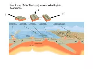
River • Running water is the most important agent of erosion on the continents and the stream valleys are the most common landforms. • Rivers flowing to the oceans drain about 68 % of the Earth's land surface. The remainder of the land either is covered by ice or drains to closed basins. • River gradually mould the land by eroding away the material in some place and depositing it in other
A river system consists of a main channel (trunk stream) and all of the tributaries that flow into it or joining the trunk stream. • A RIVER SYSTEM CAN BE DIVIDED INTO THREE SUBSYSTEMS: • collecting system (branches)-- consisting of a network of tributaries in the headwater region, collects and funnels water and sediment to the main stream • transporting system (trunk)-- the main trunk stream, which functions as a channelway through which water and sediment move from the collecting area toward the ocean. (Erosion and deposition also occur in a river's transporting system) • dispersing system (roots) -- consists of a network of distributaries at the mouth of a river (delta), where sediment and water are dispersed into an ocean, a lake, or a dry basin
Parts of River • tributary : a stream flowing into or joining a larger stream • distributary : numerous stream branches into which a river divides where it reaches its delta • upstream : moves toward headwater (up the regional slope of erosion) • downstream : moves toward mouth of river (delta) • Delta : a large, roughly triangular body of sediment deposited at the mouth of a river • Meander : a broad, looping bend in a river • Braided : river is divided into multiple channels by alluvial islands. Braided rivers tend to have steeper gradients
Dendritic Parallel Drainage Pattern • Irregular branching pattern (tree like) in many direction. • It is common in massive rocks and in flat lying strata • Due to strong resistance of rocks headward development of valley is negligible. • Parallel or sub-parallel drainage formed on sloping surface. • Common in terrain with homogeneous rocks. • Development of parallel rills, gullies or narrow channels are commonly seen on gently sloping surface
Streams radiates out from the center of the topograhic high • common in Volcanic terrain • Channels marked by right-angle bends • Commonly due to presence of joints • and fractures in the massive rocks or foliation in metamorphic rocks
Consequent Stream: A stream following the slope. Development of slope may be due to sudden tectonic uplift Subsequent Stream: A stream that develops later on, carving the softer rocks and flow at almost right angle to the original slope of the land
1 1 1 1 1 2 1 2 2 3 3 4 Stream Order Drainage Basin
FLUVIAL LANDFORMS Alluvial Fan
Alluvial fans are fan-shaped deposits of water-transported material (alluvium). • They typically form at the base of topographic features where there is a marked break in slope. • Consequently, alluvial fans tend to be coarse-grained, especially at their mouths. At their edges, however, they can be relatively fine-grained.
Braided Rivers exhibit numerous channels that split off and rejoin each other to give a braided appearance. They typically carry coarse-grained sediment down a steep gradient.
In contrast to braided rivers, meandering rivers typically contain one channel that winds its way across the floodplain. As it flows, it deposits sediment on banks that lie on the insides of curves (point bar deposits), and erode the banks on the outside of curves.
Deltas form wherever rivers encounter standing bodies of water such as lakes or oceans.
Ganga • The Ganges and Brahmaputra Rivers combined have formed one of the largest deltas in the world, comprising approximately 105 640 km2. • The Ganges River originates near the Tibet/India border, and then flows southeast across India to combine with the Brahmaputra in the country of Bangladesh. • The Brahmaputra River has its source in Tibet along the northern slope of the Himalayas, and flows across Assam into Bangladesh. The drainage basin, approximately 1.6 million km2 in area, is geologically young, with large volumes of unconsolidated sediment available for transport Bay of Bengal
Young stream Vegetation on levee
Tributaries Distributaries Trunk stream Headwater River system