Enabling EO-1 Sensor Web with OGC Standards for Enhanced Earth Observation Data Access
This document outlines the implementation of the EO-1 Sensor Web Enablement (SWE) experiment utilizing Open Geospatial Consortium (OGC) standards. It encompasses various services such as Web Map Service (WMS), Web Feature Service (WFS), and Sensor Observation Service (SOS) to facilitate the discovery, registration, and processing of Earth observation data. The integration of these technologies allows users to efficiently access, visualize, and analyze in-situ and satellite sensor data, supporting applications in Earth sciences and environmental monitoring.

Enabling EO-1 Sensor Web with OGC Standards for Enhanced Earth Observation Data Access
E N D
Presentation Transcript
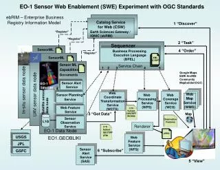
EO-1 Sensor Web Enablement (SWE) Experiment with OGC Standards USGS JPL GSFC L1G Subset GEOTIFF UTM Web Map Service (WMS) L1G Subset GEOTIFF WGS84 Observation Features JPEG ebRIM – Enterprise Business Registry Information Model Catalog Registry Catalog Service for Web (CSW) 1 “Discover” “Register” Earth Sciences Gateway / IONIC (ebRIM) “Register” 2 “Task” Sequencer SensorML 4 “Order” Business Processing Execution Language (BPEL) “Register” SensorML XML SCRIPT Service Chain Service Chain Sensor ML Capabilities Documents 1 2 3 4 5 Google Maps ESRI ArcIMS Community Mapbuilder(OGC) SAS SAS Sensor Alert Service EO-1 Satellite EO-1 Satellite In-situ sensor data node UAV sensor data node Web Coverage Service (WCS) Sensor Planning Service Web Coordinate Transformation Service (WCTS) Web Processing Service (WPS) SOS SOS Satellite sensor data node L1G WFS WFS Web Feature Service 3 “Got Data” Map L1G Sensor Observation Service SPS SPS Renderer EO-1 Data Node Web Feature Service (WFS) EO1.GEOBLIKI DEMIS Sensor Alert Service (SAS) 6 “Subscribe” 5 “View”
Glossary BPEL – Business Processing Execution Language DSS -- Decision Support System ebRIM -- Enterprise Business Registry Information Model SOS – Sensor Observation Service CSW – Catalog Services For the Web SPS – Sensor Planning Service GMSEC – Goddard Mission Services Evolution Center WCS – Web Coverage Service IML – Instrument Markup Language WCTS – Web Coordinate Transformation Service SAS – Sensor Alert Service (Pub/Sub) WFS – Web Feature Service WMS – Web Map Service WPS – Web Processing Service