Download
1 / 27
270 likes | 352 Views
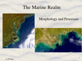
Dynamics of foreshore along Karwar beach, central west coast of India Shramik Patil* and U.G.Bhatt Dept of Marine Biology, KUPG Center, Kodibag, Karwar. INTRODUCTION.

E N D
Dynamics of foreshore along Karwar beach, central west coast of India Shramik Patil* and U.G.Bhatt Dept of Marine Biology, KUPG Center, Kodibag, Karwar
INTRODUCTION • Beaches are the most dynamic zone in the coastal areas. Continuous variations are taking place in that area. In spite of active changes, beaches are usually prone to maintain stability. • Shoreline changes and beach profile studies give information on cyclic/seasonal Morphological changes, in the area. These studies are essential to understand the Erosional and depositional features, which in turn helps in understanding changes in Oceanographic processes in the coastal areas. • Stability of a beach can be assessed from the profile changes during rough and fair weather seasons and can be monitored by recording the winds, waves, currents, tides breaker characteristics, sediment characteristics. • If the beach material is washed away during the rough weather season they are redeposited during fair weather. • Thus erosion and accretion are continues processes.
Karwar is one of the important coastal towns along the west coast of India situated at latitudes 140 50’ and longitudes 74007’ • The pre-monsoon of 2006 (30th May) witnessed cyclonic wind in the coastal Karwar, and considerable erosion occurred at various stretches of Karwar coast. The Tagore beach is one of such area, where the trees was uprooted and concrete structures erected for recreational irruption crumbled. The beach profile recorded before and after the storm has given clear picture of the erosion / accretion pattern of the sting area.
Morphology of the coast • The general orientation of the Karwar beach in N-S direction. • The sediment found on the beach is fine in nature. • The total length of the beach is 3200 mtrs and the width varies from 50-115 mtrs. • This beach is open type and the nature of the beach is moderate type. (G.N.nayak.1986).
Methods and observations • Changes in the beach are recorded at three stations at suitable interval till low tide line. • The profile is taken by emery method. (The original reference on Emery beach profiling is: emery, K O., A simple method of measuring beach profiles: Limnology and Oceanography), Two poles at about three meter length were used for measuring beach profile. • The maximum speed of wind observed in cyclonic period was 51kmph and breaker height of wave is more and beaker time is less observed. • During this period wave approached this stretch of the coast from south west in contrast to that on 29th and 30th May all along the beach breakers with height of 1.5 to 2.5 Meters with period 5 to 6 seconds making the angle to the shore lead to increase long shore currents.
Quantification of erosion and accretion (m3) at the study sites + = Accretion; - = Erosion
CONCLUSIONS • Karwar coast experiences accreting during March 2006, while erosion occur during July 2006 • The beach width varied from 50 to 115 meters. • Net changes in the sand volume at stations 1 to 3 of Karwar coast and during various seasons of study are given in the table • The maximum sand accumulation was found at St. 3 during March 2005, resulting in deposition of sand up to 180.72 m3, • Higher erosion was recorded at St 1. during, July 2006 resulting in loss of sand up to 100.21 m3. • • The sub tidal portions, which are under the water most of the time, are not much affected by the waves. • •