Mission
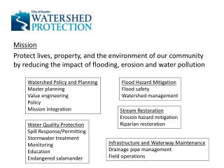
Mission Protect lives, property, and the environment of our community by reducing the impact of flooding, erosion and water pollution. Watershed Policy and Planning Master planning Value engineering Policy Mission integration. Flood Hazard Mitigation Flood safety Watershed management.

Mission
E N D
Presentation Transcript
Mission Protect lives, property, and the environment of our community by reducing the impact of flooding, erosion and water pollution Watershed Policy and Planning Master planning Value engineering Policy Mission integration Flood Hazard Mitigation Flood safety Watershed management Stream Restoration Erosion hazard mitigation Riparian restoration Water Quality Protection Spill Response/Permitting Stormwater treatment Monitoring Education Endangered salamander Infrastructure and Waterway Maintenance Drainage pipe management Field operations
Fee-funded municipal drainage utility • Residential: $9.20 residential per equivalent residential unit • Commercial: $206/impervious acre $43 M operating $23 M in Capital Improvement Project funding (~30 projects) 273 full-time employees 700 km2 full purpose jurisdiction
..does not: • Manage wastewater (AWU, TCEQ) • Manage surface water supply (LCRA, AWU) • Regulate groundwater withdrawal (BSEACD)
Flood Reduce flood impacts to life and property • Flood protection of threatened structures with drainage system improvements • Maintain Flood Early Warning System to alert the public of flood hazards • Participate in the National Flood Insurance Program and Community Rating System • Assess 10 miles of storm drain infrastructure in 2014
Flood 130 creek or rain gauges, data available in tables http://www.ci.austin.tx.us/fews/water_level.cfm http://www.ci.austin.tx.us/fews/rainfall.cfm FloodPro • Interactive floodplain location, floodplain models, and rainfall/discharge maps http://www.austintexas.gov/FloodPro/#/FloodProIntro
Flood D.I.G.
Creek Flood Hazard Mitigation Projects identified by combination of • Scoring, f(flooding depth, flow rate, velocity, resource value) • Clustering of problem areas, ranking • Evaluation of project feasibility, cost effectiveness and opportunity Structures: Street Crossings: 622 street crossing and 5,342 structures at risk
Where: PP = property protection problem score RVproperty = resource value for property protection FTproperty = flood threat for property protection n = number of flooded structures within a reach Local Flood Hazard Mitigation Prioritization Methodology Approximate Number of Storm Drain Assets • Macro-Analysis by drainage complaints • 1D Existing conditions models • Use of 2D modeling • Start with highest problem area • Create WSEL for storm events • Inlet: > 32,000 • Manhole: > 4,000 • Outfall: > 5,000 • Storm Drain System: ~1000 mi. 1,741 structures at risk
Erosion Create a stable stream system that decreases property loss from erosion and increases the beneficial uses of waterways • Design 4,000 linear feet of stream channel repairs in FY14 • Complete 1,500 feet of stream channel stabilization in FY14
Stream Restoration “Problem Score” Approach • Problem Score = f(# resources threatened, resource value, erosion severity) • Erosion Severity = f(bank height, proximity to creek, soils, vegetation, stream meander) • Individual Site Score = f(erosion site severity, resource value) • Reach Score = sum(individual site scores) within a reach Stream Reach Erosion Sites
BRIDGE/TRAIL - WALLER CREEK HOUSE – FORT BRANCH ROADWAY - BLUNN CREEK UTILITIES – SHOAL CREEK Erosion
Restoration Natural Limestone Boulder Toe with Vegetated Upper Slopes Vegetated Graded Slopes
Restoration http://www.austintexas.gov/blog/grow-zones
Water Quality Maintain or improve water quality • Construct water quality controls to reduce stormwater pollutants from 6,900 acres by FY14 • Maintain residential ponds so that 90% are functioning through FY14 • Maintain or improve baseline EII levels in 100% of watersheds • Conduct business inspections and spill response to recover 750,000 gallons and 500 cubic yards of pollutants in FY14 • Maintain 100% of activities in compliance with Federal and State permits and regulatory requirements
Water Quality 8,000 “ponds”
Water Quality Environmental Integrity Index • 121 creek reaches in 48 watersheds; 3 area lakes • Bugs, diatoms, water chemistry, sediment quality, physical integrity, contact recreation, aesthetics WASP receiving water, reservoir models Stormwater Monitoring http://www.austintexas.gov/GIS/FindYourWatershed/ http://www.austintexas.gov/watershed_protection/publications/default.cfm https://data.austintexas.gov/Environmental/Water-Quality-Sampling-Data/5tye-7ray
EII Aquatic Life -Bugs: HBI, #E, EPT, #Taxa, #Intolerant,%Dom,%Chiro, %EPT, %Pred -Diatoms: Cymbella, #Taxa,%Motile,%Sim to Ref, PTI Sediment • Metals, PAH, Pesticides Water Quality • Bacteria, TSS, NH3, NO3, OP, Conductivity Physical Integrity • Stability, Alteration, Flow Status, Embed, EpiSubstrate, Riffle Freq, Rip Zone Wid, Veg Prot, Depth Regimes, Contact Recreation • Bacteria Aesthetics • Appearance, Litter, Odor, Clarity, Volume, Algae Cover http://www.austintexas.gov/watershed_protection/publications/document.cfm?id=186267
Water Quality Public Education http://www.austintexas.gov/department/watershed-protection/education
Planning Water Quality Regulations (http://austintexas.gov/page/watershed-protection-ordinance) • SOS: Impervious cover limits to 15% • WPO: Increase headwater protection to 64 acres drainage SWAT model calibration • Daily hydrology models for most watersheds • Working on sub-daily with BMP TCEQ regulatory issues • TPDES discharge permits (stormwater, wastewater) • TMDL/Implementation Plan