Download
1 / 14
140 likes | 218 Views
Explore how Oregon's Department of State Lands (DSL) manages wetland planning tools and enforcement cases, focusing on jurisdiction, permitting timelines, and ensuring water quality standards compliance. Learn about the DSL's role in regulating and protecting resources.

E N D
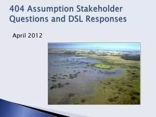
404 Assumption Stakeholder Questions and DSL Responses April 2012
State Navigable versus Federal Navigable • Side-by-side comparison of definitions: Justin Russell, OSU (HANDOUT)
Definitions • Section 404 regulates the discharge of dredged or fill material into waters of the United States. • Fill: total of deposits by artificial means (term used by the State and the Corps) • Removal: taking of material from the bed and banks of waters of this state (term used by the State) • Dredge: remove by artificial means (used by the Corps)
State permitting timelines • How many permits take over 120 days to process? Individual Permits between January 11, 2010 and December 29, 2011:
Streamlining scenarios • More details regarding options: • Why should DSL continue to regulate: • More accountable to State government • Better State agency coordination • Better coordination with State economic recovery goals/objectives • Resource Protection
Streamlining scenarios • Resource Protection: WETLAND PLANNING TOOLS • Local Wetland Inventories • LWIs are conducted by wetland consultants for local governments completing wetlands planning under Statewide Goal 5 (Natural Resources) or 17 (Coastal Shorelands) • There are 85 approved Local Wetland Inventory maps • There are 10 pending Local Wetland Inventory maps
Streamlining scenarios • Resource Protection: WETLAND PLANNING TOOLS • Wetland Land Use Notices • Total # Notices Completed Per Fiscal Year
Streamlining scenarios • Resource Protection: WETLAND PLANNING TOOLS • Wetland Delineations Completed Per Calendar Year • Wetland Determinations Completed Per Calendar Year
Streamlining scenarios • Resource Protection: WETLAND PLANNING TOOLS • Wetland Functional Assessment Tools Developed by DSL: • Oregon Freshwater Wetland Assessment Method • Hydrogeomorphic Guidebook: Statewide Classification & Profiles • Willamette Valley Ecoregion HGM • Tidal HGM • Oregon Rapid Wetland Assessment Protocol • Publications with Partners: • Wetland Land Use Change in the Willamette Valley, Oregon: 1982-1994 • Wetland Regulatory Compliance in the Willamette Valley, Oregon: 1982 to 1994 • The Wetland and Land Use Change in the Willamette Valley, Oregon: 1994-2005
Streamlining scenarios • Resource protection: ENFORCEMENTS Cases Opened between July 1, 2006 and June 30, 2011
Streamlining scenarios • Resource protection: ENFORCEMENTS Types of violations between July 1, 2006 and June 30, 2011
Streamlining scenarios • Resource Protection: JURISDICTION OF ISOLATED WATERS • Isolated wetlands include closed systems found in Eastern Oregon. Examples: • Summer Lake • Alvord Lake • Wetlands surrounding Whitehorse Creek
Some additional questions • How will State water quality standards be assured under a state assumed program? • State water quality standards must be met as part of an assumed program. We will begin discussions with DEQ to determine this process. • Implication to assumption scenarios and permitting timelines if the removal-fill program were moved to DEQ:


![1Z0-404 Dumps Questions - Oracle Communications [1Z0-404] Exam Questions](https://cdn4.slideserve.com/7939268/questions-answers-pdf-dt.jpg)