Potential Project Evaluation and Prioritization
Potential Project Evaluation and Prioritization. Indian and Howard’s Creeks Local Watershed Plan April 23, 2009. Project Evaluation and Prioritization. Stream Assessment Methods Stream Assessment Results Wetland Assessment Methods Wetland Assessment Results BMP Site Assessments

Potential Project Evaluation and Prioritization
E N D
Presentation Transcript
Potential Project Evaluation and Prioritization Indian and Howard’s Creeks Local Watershed Plan April 23, 2009
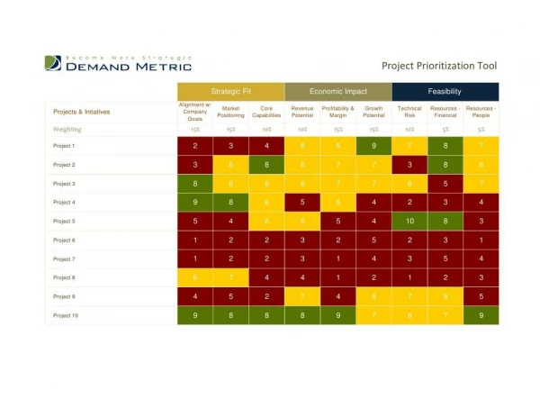
Project Evaluation and Prioritization • Stream Assessment Methods • Stream Assessment Results • Wetland Assessment Methods • Wetland Assessment Results • BMP Site Assessments • Prioritization Methodology • Stakeholder Input & NECBA
Stream Assessment Methods Phased approach • EEP provided sites to assess from Phase 1 • ENTRIX performed aerial photo and GIS evaluations to prioritize sites for field work • ENTRIX performed field assessments on 40 potential stream restoration sites and 10 potential preservation reaches • Preliminary prioritization based on field data
Stream Assessment Methods Aerial photo and GIS evaluations • 80 stream restoration sites evaluated (31.8 mi.) • 26 high priority sites based on EEP’s Phase 1 • 43 medium priority sites based on Phase 1 • 11 low priority sites based on Phase 1 (selected based on proximity to another project) • 22 stream preservation sites evaluated (15.5 mi) • All priority sites from Phase 1
Stream Assessment Methods Stream GIS and aerial photo evaluations included: • Buffer vegetation condition • Historic channelization • Presence of bank erosion or sediment deposition
Stream Assessment Methods Aerial photo buffer vegetation assessment • Percentage of 50 foot buffer zone forested based on 2005 aerial photo • 0% to 25% forested cover • 26% to 50% forested cover • 51% to 75% forested cover • 76% to 100% forested cover
Stream Assessment Methods GIS-based assessment of channelization • Based on comparison of historic aerials (1938, 1951, and/or 1968) with 2005 aerials • Included consideration of topography • Resulted in “channelized” or “not channelized”
Stream Assessment Methods Aerial photo assessment of erosion and sedimentation • Reviewed aerial photos to identify areas where erosion or deposition were present • Resulted in “erosion/sedimentation present” or erosion/sedimentation not present”
Stream Assessment Methods Field Assessments • Two person crew evaluated 40 potential restoration sites and 10 potential preservation sites • Entire reach walked up to 3,000 ft. for restoration sites or 5,000 ft. for preservation sites • Reach boundaries located with GPS • Digital images taken and field forms utilized to document conditions
Stream Assessment Methods Field Assessments • DWQ habitat assessment for piedmont and mountain streams • Stream bank stability assessment – modified HEC-20 assessment • Evaluation of channel hydraulic capacity • Evaluation of Mitigation Project Potential
Stream Assessment Methods DWQ habitat evaluation • 8 riparian and in-stream habitat metrics: • Evidence of channel modification • In-stream epifaunal habitat • Bottom substrates • Pool variety • Riffle habitats • Bank stability and vegetation • Canopy coverage • Riparian zone width
Stream Assessment Methods Channel stability assessment • Watershed land use • Flow status • Channel pattern • Entrenchment/confinement • Bed material • Bar development • Presence of obstructions • Bank soil texture/coherence • Bank angle • Bank vegetation • Bank cutting • Mass waisting/failure
Stream Assessment Methods Channel hydraulic capacity assessment • Cross-sectional area measured • To top of bank • At representative riffle • Flows computed with USGS regional regression equations for Q2 and Q10 • Channel gradient, roughness, and Q used to calculate flow area • Ratio of calculated to measured flow area developed to identify channel enlargement
Stream Assessment Results GIS-based prioritization for field assessment • Reviewed and amended by EEP • Forty stream restoration sites prioritized for field assessment (+ alternates) • Ten stream preservation sites prioritized for field assessment
Stream Assessment Results GIS assessment results Stream Restoration Parameters Stream Preservation Parameters
Wetland Assessment Methods Phased approach • EEP provided 59 sites to assess from Phase 1 • ENTRIX performed aerial photo and GIS evaluations to prioritize sites for field work • ENTRIX performed field assessments on 30 potential wetland restoration sites • Preliminary prioritization based on field data
Wetland Assessment Methods Aerial photo and GIS evaluations • 57 wetland restoration sites evaluated • All priority sites from Phase 1 • 2005 aerial photographs, • Soils GIS data (NRCS, 2007), • Topography data (EEP, 2008 • NWI data (USFWS, 1999).
Wetland Assessment Methods GIS-based wetlands assessments • Determination of mapped hydric soils • Extent of wetland vegetation • no vegetation • partially-vegetated • fully-vegetated • Proximity to NWI wetland • Proximity to potential stream project
Wetlands Assessment Methods Field Assessments • ENTRIX evaluated 30 potential restoration sites • Utilized standard USACOE assessment methodology: • Hydric Soils Evaluations • Two borings per site 2. Hydrology Assessment • Primary and secondary indicators of wetland hydrology on the USACOE form were evaluated. 3. Vegetation Characterization • A qualitative vegetation survey - several locations at each site. Dominant plant species documented based on NRCS Plant Databases indicator code. Indicator status will be recorded.
Wetland Assessment Methods DWQ staff evaluated 67 potential preservation sites (DWQ, October, 2008) • To identify and assess a random sample of jurisdictional wetlands within the Indian/Howard’s Cr. LWP area; • To calculate restoration equivalents based on potential for enhancement at each of the assessed jurisdictional wetlands, where appropriate; • To characterize the level of functioning of wetlands as a whole throughout the LWP area by using a stratified random sampling design.
Wetland Assessment Results • GIS-based prioritization for field assessment • Reviewed and amended by EEP • Thirty wetland restoration sites prioritized for field assessment (+ alternates)
Wetland Assessment Results GIS assessment results Wetland Restoration Parameters
Wetland Assessment Results • Add in maps, tables, and pictures