Download
1 / 28
280 likes | 406 Views
Wind Damage in the Lower Ohio Valley from the Remnants of Hurricane Ike. Patrick J. Spoden National Weather Service Paducah, KY Pat.Spoden@noaa.gov. Kentucky Public Services Commission Conference Call, January 2010. IKE. Over $326 Million in damage 41 injuries

E N D
Wind Damage in the Lower Ohio Valley from the Remnants of Hurricane Ike Patrick J. Spoden National Weather Service Paducah, KY Pat.Spoden@noaa.gov Kentucky Public Services Commission Conference Call, January 2010
IKE • Over $326 Million in damage • 41 injuries • 52 to 70 kt (60 to 80 mph) gusts which lasted 3 to 4 hours
IKE • Became Extra-Tropical at 12 UTC on 14 September 2008 • Remained a near steady-state compact system as it moved through the area…had very little intensification or dissipation • Most of the night, it behaved itself over Arkansas • 1 wind gust reported over 52 kts(60 mph) • 4 wind gusts reported over 43 kts(50 mph) • From NWS LZK web site • Average forward speed 22 to 26kts (25 to 30 mph) between 06 to 09 UTC
Ike @ 10 UTC Between 9 & 10 UTC The forward Speed Increased to ~52 kts (60 mph)! L First gust to 47 kts (54mph) seen
Ike @ 12 UTC First gust To 54 kts (62 mph) Seen in Northeast Arkansas at 11 UTC Gusts to 53 kts (61 mph) Now at Poplar Bluff Forward Movement ~43kts (50 mph) L
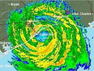
Ike @ 14 UTC Forward Speed ~43 kts (50 mph) L Strongest wind gusts seen as winds shifted to the southwest – same direction as the movement
Ike & Damage 16 UTC L 14 UTC L 12 UTC L 10 UTC L
Forward Speed • The storm remains about the same size, yet the forward speed doubled • Speed increased due to interaction with an upper level trough When Ike was in Arkansas, average wind speeds were 9 to 22kts (10-25 mph) with most gusts in the 20 – 30kt range. Ike was moving at 17-26kts (20-30 mph). L L When Ike was in our area, average wind speeds were 17 – 26kts (20-30 mph) with gusts in the 50 – 60kt range. Ike was moving at 43 to 52kts (50-60 mph).
MAV Numerical Guidance • KPAH GFS MOS GUIDANCE 9/13/20080000 UTC • DT /SEPT 13 /SEPT 14 /SEPT 15 / • HR 06 09 12 15 18 21 00 03 06 09 12 15 18 21 00 03 06 09 12 18 00 • WDR 15 17 16 19 20 20 19 16 16 14 15 17 23 27 30 30 31 33 33 01 01 • WSP 06 06 06 12 11 11 04 06 09 10 14 17 20 19 10 06 05 05 05 09 05 • KPAH GFS MOS GUIDANCE 9/13/20081200 UTC • DT /SEPT 13/SEPT 14 /SEPT 15 /SEPT 16 • HR 18 21 00 03 06 09 12 15 18 21 00 03 06 09 12 15 18 21 00 06 12 • WDR 20 20 19 16 16 14 16 19 24 27 30 29 29 34 33 36 36 35 36 36 01 • WSP 13 12 05 05 09 10 15 18 18 17 08 05 04 05 04 09 08 08 06 04 04 • KPAH GFS MOS GUIDANCE 9/14/2008 0000 UTC • DT /SEPT 14 /SEPT 15 /SEPT 16 / • HR 06 09 12 15 18 21 00 03 06 09 12 15 18 21 00 03 06 09 12 18 00 • WDR 15 16 17 21 25 28 29 29 31 33 33 36 35 35 35 34 34 34 33 01 01 • WSP 11 13 19 19 20 16 07 05 05 06 03 08 08 08 05 04 03 03 03 08 04 • *MET Guidance was even lower
Issues • Very little rain fell over the high wind area. Thus, no inversion formed. • TAMDAR sounding showed an adiabatic layer from about 850 mb down to the surface.
Operationally • Normally, we are only worried about heavy rain and attendant flooding issues • Wind Advisory in effect • High Wind Warning issued to areas near the Low center…needed to be expanded.
Affects on the Population • Occurred on a Sunday Morning – caught off guard • Most people did not even know that a wind advisory was in effect • 41 people injured, mainly due to attempting to clean up debris before the winds subsided
Kentucky Lake Courtesy WPSD-TV
TPC Report Although Ike became extratropical while moving northward over Arkansas, its remnants caused several deaths and produced significant wind damage across the Ohio Valley. At least 28 direct and indirect deaths were reported in Tennessee, Ohio, Indiana, Illinois, Missouri, Kentucky, Michigan, and Pennsylvania. In Ohio, almost 2.6 million people lost power with the most extensive damage reported in the areas near Cincinnati, Columbus, and Dayton. The Property Claim Services of the Insurance Services Office estimates that the post-tropical 11 remnants of Ike produced $2.3 billion in non-flooding related insured losses—which equates to approximately $4.7 billion in damages. Insured losses in Ohio are estimated at $1.1 billion, rivaling the 1974 Xenia tornado as the costliest natural disaster in the state’s history. http://www.nhc.noaa.gov/pdf/TCR-AL092008_Ike.pdf
Summary • Behaved itself over Arkansas • Forward speed essentially doubled after 09 UTC • Rain was light and intermittent south of the center of the system, thus expected inversion did not form • TAMDAR sounding showed dry adiabatic layer from 850 mb to the ground, which allowed wind gusts of 52 to 70 kts (60 to 80 mph) to reach the surface.
Thanks • Beverly Poole, MIC WFO PAH • Daniel Spaeth, Kevin E. Smith, Christine Wielgos – WFO PAH • Peter Browning / Jeff Manion – CRH • Jennifer Rukavina – WSPD – TV Paducah