Download
1 / 15
150 likes | 283 Views
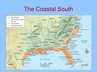
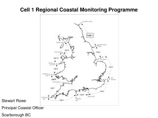
SOUTH WEST STRATEGIC REGIONAL COASTAL MONITORING PROGRAMME UPDATE. ROB WEBBON OFFICE MANAGER. Local Authorities Hydrodynamic Surveys Control Network Topographic Surveys Bathymetric Surveys. Environment Agency Aerial Photography LiDAR Surveys Ecological Surveys. PROGRAMME UPDATE.

E N D
SOUTH WEST STRATEGIC REGIONAL COASTAL MONITORING PROGRAMMEUPDATE ROB WEBBON OFFICE MANAGER
Local Authorities • Hydrodynamic Surveys • Control Network • Topographic Surveys • Bathymetric Surveys • Environment Agency • Aerial Photography • LiDAR Surveys • Ecological Surveys PROGRAMME UPDATE
LA PROGRESS • Pre-Qualification stage completed for all 3 projects • Contract awarded for Hydrodynamic Surveys • EMU Limited • Contracts have been awarded for Topographic Surveys • Work briefs have been sent out for Bathymetric Surveys
Hydrodynamic Data • 6 Directional Wave Buoys: • Moored to the seabed • Radio link to a land station • Broadband link to the CCO • Real time data every 30 minutes • Freely available as of April 2007 • Already installed at Minehead, Perranporth, West Bay and Chesil
Hydrodynamic Data • 2 Tide Gauges: • Downward looking WaveRex tide gauges • Installed on fixed structure • Broadband connection back to CCO • Real time data • One at Teignmouth, one at West Bay
Control Network • 115 points • 3 Hour occupation • Surveyed and Processed • Tied into OS and EA networks • Data to be placed on website
Topographic surveys • 5 work packages awarded to 4 contractors • Cartographical surveys won TSW1 • Contract meetings 25th and 30th January • Surveys will begin in February • 1 baseline survey • 2 interim profiles per year • 1 post storm
Bathymetric surveys • 8 work packages • Bathy work brief sent out 08/01/2007 • Surveys to begin in Summer • Single beam survey • 1 km offshore to MHWN © Titan Environmental Surveys Ltd
Aerial Photography • Simmons Aerofilm • 20% Flown • To be completed Summer 2007
LiDAR • Awarded in-house (Twerton) • 10% Flown • Currently being used to ortho-rectify aerial photos • To be completed by May 2007
LiDAR Image courtesy of Environment Agency
Office Update • All Software and Hardware up and running • 2 new employees • Strong links with University of Plymouth • All data collected, processed and analysed at Plymouth before transfer to CCO website
Working Together • Special requirements from the programme? • We aim to provide: • A regional approach • High quality data • Freely available to any interested parties • Website live from April 2007 • Historical Data