Download
1 / 14
140 likes | 342 Views
National Weather Service Partners Meeting 2009. Status of Meteorological Assimilation Data Ingest System (MADIS) Transition to Operations. David Helms Office of Science and Technology NOAA National Weather Service. Outline. Background Current Capabilities IT Architecture

E N D
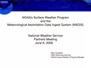
National Weather Service Partners Meeting 2009 Status ofMeteorological Assimilation Data Ingest System (MADIS)Transition to Operations David Helms Office of Science and Technology NOAA National Weather Service
Outline • Background • Current Capabilities • IT Architecture • Program Status and Deliverables • Next Steps • R2O Status and Post-FOC PPI
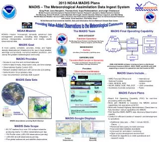
Background • History MADIS was established in 2001 to prototype new access, integration, quality control, and distribution techniques for real time observation data • Goal • Easy access to quality-controlled data from a wide variety of observing infrastructures • Local, state, federal agencies, and private industries • Standardized, more accurate, and higher density observational infrastructure
Background (cont.) • Access type: • How: Local Data Monitor (LDM) Pull, FTP (push and pull), XML (pull) • Who: NOAA, Federal Agencies, Private Sector, Universities • Integration: • MADIS generates products in standardized text-based format to facilitate inter-comparisons and access • Quality control: • What is provided: Automated QC Checks, e.g., Gross Error Checks, Temporal Consistency and Spatial Consistency (e.g. buddy-checks); Station Monitoring Statistics such as Frequency of Failure, Bias and Standard Deviation Statistics • What are its limitations/scope: Basis of statistics is analysis field based on elevation corrected station buddy-checks; therefore, analysis is a good as the stations that comprise it (generally good) • MADIS QC CONOPS: application independent, real-time mission support requiring low latency • Where does MADIS run? • Pre-IOC: Primary @ GSD ; Physical Backup: NA • Post-IOC: Primary @ Gateway/NCO, Physical Backup: GSD
Background (cont.) Supported Capabilities • Integrated observations with uniform formats and time stamps • On-the-fly, flexible, data reformatting • Continuous database updates triggered by arriving observations • Increased data density • High temporal resolution • Web-enabled push/pull distribution capabilities, with server-side metadata, parameter, spatial and temporal parsing capabilities • Seamless access to real-time and saved datasets • Secure authentication for proprietary data
Current Capabilities • Data Portfolio: • >58,000 Surface Stations producing over 11,600,000 observations/day • 134 Profiler Sites (> 200,000 observations/day) • Over 450,000 aircraft observations/day • Plus global radiosonde and satellite observations • Service: • Availability: • Current objective 99.0% with regular business hour support • Post-FOC will be 99.5% with 24/7 tech support at NCO & TOC • Strong support from a wide and diverse users base • “MADIS data has proved incredibly helpful in increasing overall situational awareness ... with major wind and winter storm events, along with a severe weather event.” -- Brian Crumpler - GIS Manager, Virginia Department of Emergency ManagementPreparedness Division
MADIS Computing Environment NCEP TOC Decoders Ingest Distribution Integration and Quality Control IT Architecture Strategy: Port the existing GSD MADIS software to an integrated NWS TOC and NCO distributed environment, with a supporting backup and research-to-operation test environment at GSD Internet
Next Steps – IOC and FOC Milestones • Initial Operating Capability (IOC): FY2010-Q3 • Raw ingest (ftp/http/ldm) at NWS/TOC • Distribution servers (ftp/http/ldm) at NWS/TOC • Operator monitoring for data ingest and distribution servers at NWS/Gateway • Operator monitoring for processing servers at NWS/NCO • Help Desk (GSD primary/NWS backup) • Real-time processing subsystems running at NWS/NCO • Security Certification and Accreditation completed on NWS/TOC server • Other current MADIS capabilities sustained at OAR/ERSL/GSD • Full Operating Capability (FOC): FY2011-Q3 • Observation web displays on NWS/Gateway MADIS web server • Cooperative Agency Profiler Hub (including dialers) at NWS/TOC • Surface data recovery system at NWS/NCO • Additional operator and software documentation • Help Desk (NWS primary/GSD backup) • Archive (saved real-time data) development with NESDIS/NCDC
FY2009 FY2010 October 1, 2008 October 1, 2009 October 1, 2010 Port Real-Time Processing to NCEP Port I/O Software and Hardware to the TOC Install I/O Software and Hardware at the TOC October 1, 2009 End-to-End Testing Training / C&A OT&E Resolve OT&E Issues IOC June 3, 2010 April 1, 2009 April 1, 2010 Next Steps - IOC Original IOC Date On Track
FY2010 FY2011 FY2012 June 1, 2010 April 1, 2011 April 1, 2012 Port Data Recovery Process to NCEP Port Web Displays to TOC MADIS Servers CAP Port to TOC Install CAP Hardware and Software January 14, 2011 … Prepare Archive for Transfer to NCDC End-to-End Testing OT&E (4/14/11 – 4/29/11) FOC June 14, 2011 Resolve OT&E October 1, 2010 October 1, 2011 Next Steps - FOC
Post-FOC Planned Product Improvement • Infrastructure Capacity Building: • Advanced data mining, SOA, and web services; • Expanded metadata fields • Additional datasets; and • Improved and expanded observation QC will serve: • Service Area Support: • NextGen – includes high frequency ASOS • National Surface Weather Observing System (NSWOS)/FHWA support • Historic Climate Network – Modernized (HCN-M) • UrbaNet, National Mesonet • Next Generation NOAA Profiler Network (NGNPN) • UAS data management • Testbeds (HMT, DTC, Severe Weather Testbed) • Fire weather mobile observations • DHS support e.g. WISDOM Balloons
Questions? David Helms Email: david.helms@noaa.gov Phone: 301-713-3557 x193