Enhancing MODIS Geolocation Accuracy for Terrestrial Geophysical Parameter Retrieval
The MODIS science team has developed advanced remote sensing algorithms to create global time-series data products for various terrestrial geophysical parameters. Accurate geolocation is crucial for effective change detection and biophysical parameter retrieval over diverse land surfaces. The accuracy goal is set at 0.05 km for a 1 km pixel. Despite achieving good results, some inaccuracies still exist, particularly after orbit maneuvers. The study emphasizes the need for improved geolocation methods and the usage of refined calibration techniques for better data accuracy in terrestrial observations.

Enhancing MODIS Geolocation Accuracy for Terrestrial Geophysical Parameter Retrieval
E N D
Presentation Transcript
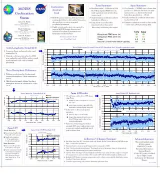
Aqua Summary Terra Summary MODIS Geolocation Status • Geolocation • Accuracy • Goal • MODIS science team has developed remote sensing algorithms to derive global time-series data products on various terrestrial geophysical parameters • Highly accurate geolocation are required to support MODIS change detection and retrieval of biophysical parameters over heterogeneous land surfaces Accuracy Goal is 0.05 of a 1 km Pixel (1s) • Good results – C4 RMS error is better than goal in track direction but does not quite meet goal in scan direction (but much better than specification – 150 m) • Early post-launch coordinate system issue resolved before C4 • Definitive ephemeris is used for best results – causes up to 24 hr processing delay • Excellent results – Collection 4 (C4) Root Mean Square (RMS) error in nadir equivalent units is better than accuracy goal • Small remaining northern/southern hemisphere difference • Large errors occur after orbit maneuvers (about 6 per year) • accuracy in following orbit suspect Robert E. Wolfe Raytheon ITSS @ NASA Goddard Space Flight Center, Code 922Greenbelt, MD, USA Mash Nishihama Raytheon ITSS @NASA Goddard Space Flight Center, Code 922, Greenbelt, MD, USA James A. Kuyper SAIC/GSC @NASA Goddard Space Flight Center, Code 922, Greenbelt, MD, USA Terra Daily Ground Control Point (GCP) Residuals for C4 (nadir equivalent units) Terra Long-Term Trend (LTT) daily mean (dots) and standard deviation (bars) • Long-term linear and annual cyclic trend removed in C4 • Original coefficients derived in late 2002 were updated in early 2004 to reflect overall trend (updated coefs. only in forward processing) Terra Hemispheric Differences • Different trends found in Northern and Southern hemisphere – likely temperature related • Global trend primarily follows Northern hemisphere because it contains 80% of the GCPs Aqua C4 Results Aqua Daily GCP Residuals (C4) Terra 16-day GCP Residuals (C4) 16-day mean • Overall scan residuals are 30% larger than Terra • AMSR-E jitter contributes to some of this error • some improvements expected with new mirror interpolation approach • Early mission data needs special attention • first 30 days is out of family • larger than expected track error in first 150 days may be due to less accurate ephemeris • Removal of remaining star tracker anomaly (125 msec readout time error in one star tracker) would help reach goal for future data daily mean (dots) and standard deviation (bars) Aqua LTT Aqua 16-day GCP Residuals (C4) Track direction • Linear trend smaller than Terra (10 vs. 15 m/year) • Small cyclic variation (~10 m amplitude in Southern hemisphere) Scan direction • Linear trend larger than Terra (20 vs. 4 m/year) • Cyclic variation primarily in Southern hemisphere (opposite hemisphere from Terra) and larger than Terra (20 vs. 11 m amplitude) 16-day mean Collection 5 Changes Summary Acknowledgement This work funded under NASA contract NAS5-32373 in the Terrestrial Information Systems Branch (Code 922) at the Goddard Space Flight Center Laboratory for Terrestrial Physics. July 13, 2004 • Ancillary data: New BU Land/sea mask and Shuttle Radar Terrain Mission (SRTM) terrain data – both under evaluation • Improved mirror motion model (approved for remainder of C4) • New “GeolocationAccuracySuspect” flag based on list of maneuver times to help exclude data near/after maneuvers from science production • Update Terra and Aqua LTT and implement ability to use solar elevation angle as surrogate for temperature to remove within-orbit variation (North/South hemispheric differences) • Refresh GCP library to remove some points and to obtain a more global distribution using Landsat-7 GeoCover data set • Consider reprocessing early mission definitive ephemeris data