Cali forn ia Coast l ine
190 likes | 359 Views
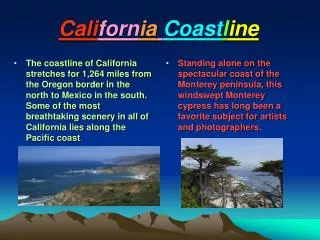
Cali forn ia Coast l ine. The coastline of California stretches for 1,264 miles from the Oregon border in the north to Mexico in the south. Some of the most breathtaking scenery in all of California lies along the Pacific coast .

Cali forn ia Coast l ine
E N D
Presentation Transcript
CaliforniaCoastline The coastline of California stretches for 1,264 miles from the Oregon border in the north to Mexico in the south. Some of the most breathtaking scenery in all of California lies along the Pacific coast. Standing alone on the spectacular coast of the Monterey peninsula, this windswept Monterey cypress has long been a favorite subject for artists and photographers.
SanFranciscoBay San Francisco Bay, one of the finest natural harbors in the world, covers some 450 square miles. It is two hundred feet deep at some points, most of the harbor is less than twelve feet deep. The bay region, the only real break in the coastal mountains, is the ancestral homeland of the Ohlone and Coast Miwok Indians. It became the gateway for newcomers heading to the state's interior in the 1800’s and 1900’s. Map
San Diego Bay • A variety of the Kumeyaay people have lived around the shores of San Diego Bay for thousands of years. • European settlement began in 1769 with the arrival of the first Spanish missionaries. • The bay was seized by United States Marines during the Mexican-American War in 1846-1848. • The coming of the Santa Fe railroad in 1885 spurred population growth as did the establishment of major army and navy bases during World War I. Map
Los Angeles Basin • It’s the largest lowland area in California that directly fronts the ocean. • Longtime home of the Tongva people. • During 1880s, the population of Los Angeles swelled from 11,000 to 50,000. • Construction of a huge breakwater along the harbor at San Pedro began in 1899 and was later made larger to protect both the harbors of San Pedro and Long Beach. Map
Map of California #1 San Francisco Bay Los Angeles Basin San Diego Bay
Mountainsof California • Mountains cover most of the surface of California. • Mountain ranges isolated the different Native American cultures that prospered within these boundaries. • The mountains also were formidable barriers during the early decades of European American exploration and settlement.
Mountainsof California Continued • Mount Whitneyis the highest point inside the contiguous United States and is 14,495 feet above sea level. • Mount Shastais a dormant volcano whose summit is 14,162 feet above sea level. • Mount Lassenis just to the south of Mount Shasta and stands 10,457 feet above sea level. Mt. Lassen was an active volcano in the early 1900’s. Map
Sierra Nevada • The largest mountain range in California. It occupies 1/5 of the total area of the state. • It runs more than 400 miles along California'seastern border. • The eastern side of the Sierra Nevada rises steeply, whereas the western side has a more gentle slope.
Sierra Nevada -Continued • Forests of pine, fir, and cedar cover the lower elevations. • Rushing mountain rivers have cut dozens of deep canyons in the western Sierra. • The gold that was discovered in 1848 was eroded from rock in the high Sierra and deposited in stream banks and ancient riverbeds of the western foothills. Map
Coast Ranges • The Coast Ranges extend from Cape Mendocino in the north to Point Conception in the south. They average less than 4,000 feet in height • They are made up of uplifted sedimentary material, and metamorphic rock. On the seaward slopes of the northern ranges are forests of coast redwoods, greatly reduced by more than a century of commercial logging. • Mount Hamilton, a 4,261-foot peak located east of San Jose, is the site of the Lick Observatory, built in 1888. • Mount Diablo, rising to 3,849 in eastern Contra Costa County, was the scene of coal-mining activity in the 1860s. Map
Map of California - #2 Mount Shasta Mount Lassen Sierra Nevada Coastal Ranges Mount Whitney
CentralValley • The Central Valley lies between the Coast Ranges and the Sierra Nevada. More than four hundred miles long and about fifty miles wide, the Central Valley is the most productive agricultural area in California. • Oak woodlands and bunchgrass prairies once covered the valley floor and great tule marshes extended over the flood plain. Beavers in the inland streams first lured European Americans across the continent to California in the 1820s. • Irrigated cropland today covers most of the valley and produces more agricultural products than any comparable region in the world.
San Joaquin Valley • Ancestral home of the Yokuts and Miwok Indians, the San Joaquin Valley extends southward from the Sacramento River to the Tehachapi Mountains. • European Americans first entered the valley in the 1770’s, pursuing deserters from the coastal missions. • After the gold rush European settlers established vast wheat farms on the valley's fertile soils. The coming of the Southern Pacific Railroad triggered further agricultural development. • The great Central Valley Project, constructed in the mid-twentieth century, guaranteed sufficient water for the diversification of crops. Map
Sacramento Valley • Flowing through the heart of the valley is the four hundred-mile long Sacramento River. The Sacramento River carries one-third of the annual runoff of all California streams, the largest river in the state. • Many Native American cultures flourished in the Sacramento Valley prior to European exploration in the late eighteenth century. • Johann Sutter established the first European settlement in the valley where the Sacramento and American rivers join. During the gold rush many people heading for the mines in the Sierra Nevadas crossed the valley. Sacramento, Marysville, Yuba City, and other towns flourished as supply centers for the miners. Map
California Deserts • Much of the eastern half of southern California is a large desert triangle--a large area of sandy valleys, dried lake beds, and short ranges of rugged mountains. • These southern deserts were as much a barrier to overland migration to California in the 1700’s as the steep eastern face of the Sierra Nevada was in the 1800’s.
Mojave Desert • The Mojave is the largest desert in California, covering some 25,000 square miles. • Active volcanoes erupted long ago, depositing layers of lava, mud, and ash onto the desert floor. • Native American cultures, including the Quechan (Yuma) and Mojave, lived along the Colorado River. The Cahuilla and Serrano, lived farther west. • The Old Spanish Trail crossed the region in the late eighteenth century, as did the Santa Fe railroad in the nineteenth. • Dry lake beds contain rich deposits of boron, a valuable mineral used for jet-engine and rocket fuels. Map
Colorado Desert • The Colorado Desert stretches over 4,000 square miles in southeastern California. Part of the desert lies 245 feet below sea level at some points. • The Colorado Desert includes the Coachella and Imperial valleys with the Salton Sea between. • The Salton Sea was formed in 1905-1907 when waters from the Colorado River overflowed an irrigation system. • Palm Springs is an rich resort community, famous for its warm winter sunshine and star-studded population. Map
Death Valley • The most well known of the California deserts. It is a deep trough about 130 miles long and six to fourteen miles wide. • In the center of the valley is Badwater, the lowest point in the Western Hemisphere at 282 feet below sea level. • Death Valley was named by a group of gold-miners who struggled through the area in 1849. • After large amounts of borax was discovered in 1873, the valley became famous for its twenty-mule teams hauling out wagon-loads of this valuable mineral. Map
Map of California #3 Sacramento Valley Death Valley San Joaquin Valley Colorado Desert Mojave Desert