Download
1 / 17
170 likes | 338 Views
Impacts of the December 2006 Solar Radio Bursts on the Performance of GPS. Charles S. Carrano 1 Keith M. Groves 2 Christopher T. Bridgwood 1 Boston College, Institute for Scientific Research Air Force Research Laboratory.

E N D
Impacts of the December 2006 Solar Radio Bursts on the Performance of GPS Charles S. Carrano1 • Keith M. Groves2Christopher T. Bridgwood1 • Boston College, Institute for Scientific Research • Air Force Research Laboratory NOAA/SWPC Space Weather WorkshopBoulder, CO • April 27-30, 2010
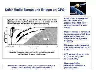
StrengthDateStartPeakStop X9.0Dec 510:1810:35 10:45 X6.5Dec 618:2918:4719:00 X3.4Dec 1302:1402:40 02:52 X1.5Dec 1421:0722:1522:26 Extreme Solar Activity from Active Region 10930 Solar Flare L-band Peak Flux (sfu) Dec 5 3,900 Dec 6~1,000,000 Dec 13 440,000 (1 GHz) Dec 14 120,000 • The solar flare on Dec 5 was the most intense in terms of X-ray flux, but produced the least power at L band where GPS operates. • The solar radio burst on Dec 6 generated unprecedented levels of wideband noise at L band which substantially degraded GPS tracking and positioning accuracy for entire sunlit hemisphere. Reference: Gary (2008) Slide 2
Global Extent of the Impact from the Dec 6 SRB Wide Area Augmentation System Figures from Cerruti et al. (2008) x Most of the IGS/CORS/WAAS receivers record data at ~30 second cadence. In this talk we examine the impacts on high-rate GPS measurements provided by the AFRL-SCINDA network. Slide 3
AFRL-SCINDA Ground Stations (as of Dec 2006) • Specialized GPS receivers of the SCINDA network record C/No, pseudorange, and phase on L1 and L2 between 10-50 Hz (dual frequency systems shown in yellow) • Region where the December 6 SRB degraded GPS performance is outlined in purple
December 6, 2006 X6.5 Flare and Solar Radio Burst Slide 5
L1 L2 OVSA Solar Radio Burst RHCP Power SRB RHCP Power exceeded 106 SFU at L band Sub-solar point at 19:34 UT was (22.5S, 115.7W) Figures from Cerruti et al. (2008) Slide 6
L1 C/No L2 C/No PRN 02 PRN 02 PRN 04 PRN 04 dB-Hz dB-Hz PRN 08 PRN 08 L1 PRN 27 PRN 27 L2 PRN 28 PRN 28 18:30 18:30 18:45 18:45 19:00 19:00 19:15 19:15 19:30 19:30 19:45 19:45 20:00 20:00 UT UT GPS Carrier-to-Noise at Ancon on Dec 6 GPS receiver model: Ashtech Z-12 34° solar incidence angle at 19:15 UT L1 tracking loss L2 tracking loss Longest L1 fade: 4 min Deepest L1 fade: 25 dB Longest L2 fade: 9 min Identical fades on all links (weak dependence on satellite elevation because SIA is the same) Deepest L2 fade: 30 dB
Differential Pseudorange Differential Carrier Phase PRN 02 PRN 02 PRN 04 PRN 04 Meters TECU PRN 08 PRN 08 PRN 27 PRN 27 PRN 28 PRN 28 18:30 18:30 18:45 18:45 19:00 19:00 19:15 19:15 19:30 19:30 19:45 19:45 20:00 20:00 UT UT GPS Pseudorange and Phase at Ancon on Dec 6 GPS receiver model: Ashtech Z-12 34° solar incidence angle at 19:15 UT SITEC (enhanced ionization from flare) of 5 TECU in 3 min, starting just before peak of flare (18:47) Ranging errors (not ionospheric delay) Cycle slip (TEC becomes difficult to measure) Ranging errors (on L1, L2 or both) exceed 100 m. These will contribute to net GPS positioning error
18:30 18:30 18:45 18:45 19:00 19:00 19:15 19:15 19:30 19:30 19:45 19:45 20:00 20:00 UT GPS Position Solution at Ancon on Dec 6 GPS receiver model: Ashtech Z-12 34° solar incidence angle at 19:15 UT Satellites Tracked / GDOP No. Satellites Degraded tracking Position Outages (5 min total) Max 43.4 GDOP Position Error Horizontal (m) Position Errors:20 m horizontal60 m vertical Vertical (m)
Comparing Observations from Different Locations: Accounting for the Local Solar Incidence Angle and GPS Antenna Gain Slide 10
SRB Power and the Solar Incidence Angle C/No without SRB: Ashtech Choke Ring Antenna Gain, g() broadcast power system noise C/No with SRB: SRB power (satellite elevation cancels): Vertical equivalent (zenith) C/No with SRB (system noise cancels): Atmospheric attenuation neglected (<1 dB at L band)
L1 C/No Vertical Equivalent L1 C/No PRN 08 PRN 08 Ancon Ancon dB-Hz dB-Hz PRN 08 PRN 08 Antofagasta Antofagasta PRN 08 PRN 08 Sao Luis Sao Luis PRN 29 PRN 29 Kwajalein Kwajalein 18:30 18:30 18:45 18:45 19:00 19:00 19:15 19:15 19:30 19:30 19:45 19:45 20:00 20:00 UT UT C/No Reductions at L1 from Different Stations C/No reductions are very similar for any sunlit location once solar incidence angle correction applied Solar incidence angles at 19:15 UTAncon: 34°Antofagasta: 37° Sao Luis: 68° Kwajalein: 86° Signal blocked by ground obstruction Maximum vertical equivalent L1 fade: 27 dB
L2 C/No Vertical Equivalent L2 C/No PRN 08 PRN 08 Ancon Ancon dB-Hz dB-Hz PRN 08 PRN 08 Antofagasta Antofagasta PRN 08 PRN 08 Sao Luis Sao Luis PRN 29 PRN 29 Kwajalein Kwajalein 18:30 18:30 18:45 18:45 19:00 19:00 19:15 19:15 19:30 19:30 19:45 19:45 20:00 20:00 UT UT C/No Reductions at L2 from Different Stations C/No reductions are very similar for any sunlit location once solar incidence angle correction applied Solar incidence angles at 19:15 UTAncon: 34°Antofagasta: 37° Sao Luis: 68° Kwajalein: 86° Maximum vertical equivalent L2 fade: 30 dB
Why Were these Events Different and will they Recur? • These extreme solar radio flux densities were caused by an unusually high density of spike bursts due to the Electron-Cyclotron Maser (ECM) mechanism. • The December 6 solar radio burst reached a flux density of at least 106 sfu at 1.4 GHz, momentarily reaching flux densities as high as 2.5x10⁶ sfu during individual spikes. • Bursts of 106 sfu, if they follow the general size distribution of solar bursts, should occur every 15 years at solar maximum rates, or every 100 years at solar minimum rates. The events of 2006 December 6 are therefore extremely rare occurrences. • In the historical record the largest bursts are missing, however, probably due to instrument saturation effects. This leaves open the question of how often such large events will occur. Sources: Gary, D. E. (2008), Cause and Extent of the Extreme Radio Flux Density Reached by the Solar Flare of 2006 December 06, Proceedings of the 2008 Ionospheric Effects Symposium. Kintner, P. M. Jr., O'Hanlon, B., Gary , D. E., & Kintner, P. M. S. (2009), Global Positioning System and Solar Radio Burst Forensics, Radio Science, 44, RS0A08. Slide 14
Conclusions • The solar radio bursts in December 2006 resulted in unprecedented levels of wideband RHCP power at the GPS L1 and L2 frequencies. The solar radio burst on December 6 significantly degraded overall GPS performance on a global basis. • All the AFRL-SCINDA GPS receivers on the sunlit hemisphere observed nearly identical patterns of intermittent C/No fading during each burst, lasting up to an hour. • The GPS C/No reductions, some as deep as 25 dB, were modulated by the local solar incidence angle and antenna gain. The maximum vertical equivalent reduction at L1 was ~27 dB. • SITEC events were observed in conjunction with all four associated solar flares, at rates between 0.4-1.2 TECU/min. These rates appeared to vary according to the solar incidence angle. • Under these conditions, the SCINDA GPS receivers experienced difficulty tracking and also incurred ranging errors associated with loss of code lock. These factors led to elevated GPS positioning errors of up to 20/60 meters in the horizontal/vertical directions. • These solar radio bursts came as a surprise during solar minimum, and suggest that loss of GPS operations during solar maximum could be more common than previously anticipated.
References Carrano, C. S., C. T. Bridgwood, and K. M. Groves (2009), Impacts of the December 2006 solar radio bursts on the performance of GPS, Radio Sci., 44, RS0A25, doi:10.1029/2008RS004071. Cerruti, A. P., P. M. Kintner, D. E. Gary, L. J. Lanzerotti, E. R. de Paula, and H. B. Vo (2006), Observed solar radio burst effects on GPS/Wide Area Augmentation System carrier-to-noise ratio, Space Weather, 4, S10006, doi:10.1029/2006SW000254. Cerruti, A. P., P. M. Kintner, D. E. Gary, A. J. Mannucci, R. F. Meyer, P. Doherty, and A. J. Coster (2008), Space Weather, 6, 10, doi:10.1029/2007SW000375. Gary, D. E. (2008), Cause and Extent of the Extreme Radio Flux Density Reached by the Solar Flare of 2006 December 06, Proceedings of the 2008 Ionospheric Effects Symposium. Kintner, P. M. Jr., O'Hanlon, B., Gary , D. E., & Kintner, P. M. S. (2009), Global Positioning System and Solar Radio Burst Forensics, Radio Science, 44, RS0A08. Slide 16
Thank You for Listening Chloë Trester Carrano was born on April 11, 2010 in Cambridge, MA. She weighed 7 pounds 9.5 ounces and was 21 inches tall. Slide 17