Multi-platform Satellite Surface Wind Analysis for Tropical Cyclones
10 likes | 197 Views
Multi-platform Satellite Surface Wind Analysis for Tropical Cyclones. John A. Knaff 1 (GOVERNMENT PRINCIPAL INVESTIGATOR) 1 NESDIS/STAR/CoRP. Requirement: Weather and Water - Improve Weather Forecast and Warning Accuracy and Amount of Lead-time.

Multi-platform Satellite Surface Wind Analysis for Tropical Cyclones
E N D
Presentation Transcript
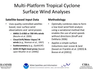
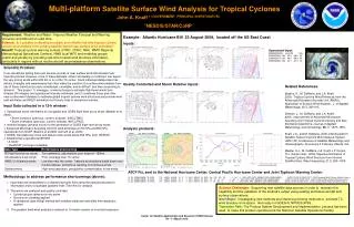
Multi-platform Satellite Surface Wind Analysis for Tropical Cyclones John A. Knaff 1 (GOVERNMENT PRINCIPALINVESTIGATOR) 1NESDIS/STAR/CoRP Requirement: Weather and Water - Improve Weather Forecast and Warning Accuracy and Amount of Lead-time. Science:Is it possible to develop a realistic and reliable real-time tropical cyclone surface wind analysis from existing satellite-based near-surface wind estimates? Benefit: Tropical cyclone warning centers (JTWC, CPHC, NHC, WMO Regional Meteorological Specialized Centers), NWS local WFO and modeling groups (public and private) by providing real-time tropical wind structure information, particularly in regions without routine aircraft reconnaissance observations. Example: Atlantic Hurricane Bill 23 August 2009, located off the US East Coast Inputs: Quality Controlled and Storm Relative Inputs: Analysis products: Operational Input: 200908230025 AL0309 BILL 2009082206 234 32.2 -68.2 90 2009082218 234 36.0 -68.9 80 2009082306 235 40.1 -67.2 74 • Scientific Problem: • In an operational setting there are several sources of near surface wind data located near tropical cyclones. However, none of these datasets, either individually or combined, can depict the very strong winds within 200 km or so of the TC center. Each individual dataset also has distinct strengths and weaknesses that often make the creation of a surface wind analysis from any of these individual sources complicated, unreliable, and/or difficult and time consuming to interpret. This project 1) leverages a new technique to estimate flight-level winds from infrared (IR) imagery and operational intensity estimates, and 2) combines those and other near-surface wind datasets to estimate global tropical cyclone wind structures and provide wind radii estimates and MSLP estimates via 6-hourly fixes to operational centers. • Input Data collected in a 12-h window: • Operational storm information for navigation and GOES flight-level proxy winds (Mueller et al. 2006). • Storm locations (previous, current, forecast , NHC/JTWC) • Storm intensities (previous, current, forecast, NHC/JTWC) • Infrared imagery (several hours) for the generation of GOES flight-level proxy winds • Advanced Microwave Sounding Unit 2-D wind estimates at 700 hPa and 850 hPa, operational from NCEP (Bessho et al 2006, Demuth et al. 2006) • GOES/ Geostationary cloud and feature track winds below 600 hPa, from NESDIS • Scatterometry operational NESDIS • A-SCAT • QuikSCAT (no longer available) • Methodology to address performance shortcomings (above): • Input data are interpolated to a standard synoptic time using the operational position information and to a standard gradient level (700 hPa) for analysis • The winds are analyzed and quality controlled • Cylindrical grid centered on the storm • Gross error checking applied • A variational (data fitting) method with variable radial and azimuthal filter weights is applied. • The gradient level wind analysis is reduced to 10-meter oceanic or over-land exposure. Related References: Bessho, K., M. DeMaria, and J.A. Knaff, 2006: Tropical Cyclone Wind Retrievals from the Advanced Microwave Sounder Unit (AMSU): Application to Surface Wind Analysis. J. of Applied Meteorology. 45:3, 399-415. Demuth, J., M. DeMaria, and J.A. Knaff, 2006: Improvement of Advanced Microwave Sounding Unit Tropical Cyclone Intensity and Size Estimation Algorithms, Journal of Applied Meteorology and Climatology, 45:11, 1573–1581. Knaff, J.A., and M. DeMaria, 2006: A Multi-platform Satellite Tropical Cyclone Wind Analysis System. AMS 14th Conference on Satellite Meteorology and Oceanography. 29 January-3 February, Atlanta, GA. Mueller, K.J., M. DeMaria, J.A. Knaff, J.P. Kossin, T.H. Vonder Haar:, 2006: Objective Estimation of Tropical Cyclone Wind Structure from Infrared Satellite Data. Wea Forecasting, 21:6, 990–1005. ATCF Fix, sent to the National Hurricane Center, Central Pacific Hurricane Center and Joint Typhoon Warning Center: AL, 03, 200908230000, 70, ANAL, PR, , 3802N, 6828W, 10 , 2, , 2, 984, 2, MEAS, 34, NEQ, 235, 230, 140, 145, , , , , 2, 40, , L, CIRA, MPS, MPS, 200908221200, 200908230025, , , AMSU CD WV IR SSMI QSCT , CIRA Combined Multi-Platform Satellite Analysis AL, 03, 200908230000, 70, ANAL, PR, , 3802N, 6828W, 10 , 2, , 2, 984, 2, MEAS, 50, NEQ, 80, 80, 45, 55, , , , , 2, 40, , L, CIRA, MPS, MPS, 200908221200, 200908230025, , , AMSU CD WV IR SSMI QSCT , CIRA Combined Multi-Platform Satellite Analysis AL, 03, 200908230000, 70, ANAL, PR, , 3802N, 6828W, 10 , 2, , 2, 984, 2, MEAS, 64, NEQ, 0, 55, 40, 0, , , , , 2, 40, , L, CIRA, MPS, MPS, 200908221200, 200908230025, , , AMSU CD WV IR SSMI QSCT , CIRA Combined Multi-Platform Satellite Analysis Science Challenges: Supporting new satellite data sources in order to maintain this capability and the validation of the method’s output using existing and future aircraft and surface observations. Next Steps:Investigating new methods and improving existing methods to estimate TC wind structure from space. Get ready for GOES-R, NPOES/JPSS. Transition Path: The Product System Development and Implementation process has been used to make this product operational at the National Satellite Operations Facility.