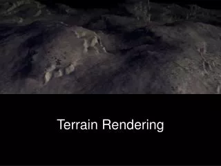
World-Scale Terrain Rendering
World-Scale Terrain Rendering. (Slides: cesium.agi.com / massiveworlds ). Kevin Ring Analytical Graphics, Inc. Terrain in Cesium. Terrain in Cesium. Terrain in Cesium. Terrain in Cesium. Terrain in Cesium. Terrain in Cesium. Terrain in Cesium. Real-world d ata.

World-Scale Terrain Rendering
E N D
Presentation Transcript
World-Scale Terrain Rendering (Slides: cesium.agi.com/massiveworlds) Kevin Ring Analytical Graphics, Inc.
Real-world data • Terrain and imagery collected by satellites and aerial instruments • Shuttle Radar Topography Mission (SRTM) • National Elevation Dataset (NED) • Landsat satellites • Digital Globe, SPOT, etc. • Terrain usually provided as a heightmap
Unfortunately… • The best data is hidden: • Within private networks • Within classified networks • Behind pay walls • By strict terms of use restrictions • Data is huge – up to hundreds of terabytes • We can’t access it ahead of time to transform it to a different form.
Terrain and imagery sources • Web Map Service (WMS) • Web Map Tile Service (WMTS) • Tile Map Service (TMS) • ArcGIS Map and Image servers • OpenStreetMap • Bing Maps • Google Maps
Layers are different • Different: • Map projections • Extents • Tiling schemes • May need on-the-fly adjustments: • Hue • Saturation • Gamma
Agenda • Overview of LOD algorithm – Chunked LOD • Mapping imagery to terrain • Map reprojection on the GPU • Horizon culling
Agenda • Overview of LOD algorithm – Chunked LOD • Mapping imagery to terrain • Map reprojection on the GPU • Horizon culling
Chunked LOD [Ulrich02] http://tulrich.com/geekstuff/chunklod.html
Screen-space error (SSE) ε = geometric error of tile or level, in meters x = width of the screen, in pixels d = distance to tile, in meters θ = camera field of view, in radians
Geometric Error, ε Geometric error is constant per level in the quadtree [Klein96]
Distance to tile, d • Accurate approach: distance to closest triangle • Simple approach: distance to bounding sphere • Balanced approach: distance to • Maximum height surface • East and West boundary planes • North and South approximate boundary planes
Load Pipeline Imagery Tile Terrain Tile Imagery Tile Associate Imagery Request Upsample Request Transform Transform Create Texture Create Resources Create Resources Reproject
Agenda • Overview of LOD algorithm – Chunked LOD • Mapping imagery to terrain • Map reprojection on the GPU • Horizon culling
Texture Scale imageryHeight scaleX= terrainWidth/ imageryWidth scaleY= terrainHeight/ imageryHeight imageryWidth terrainHeight terrainWidth
Texture Translation offsetX translationX= scaleX * offsetX / terrainWidth translationY= scaleY * offsetY / terrainHeight offsetY
Texture Extent offsetX extentMinX = offsetX / terrainWidth extentMinY = offsetY / terrainHeight extentMaxX = (offsetX + imageryWidth) / terrainWidth extentMaxY = (offsetY + imageryHeight) / terrainHeight offsetY
Agenda • Overview of LOD algorithm – Chunked LOD • Mapping imagery to terrain • Map reprojection on the GPU • Horizon culling
Map Reprojection Geographic / Plate Carrée (EPSG:4326) Web Mercator (EPSG:3857)
Web Mercator Reprojection mercatorY = 0.5 * log((1.0 + sinLatitude) / (1.0 - sinLatitude)) mercatorOffset= mercatorY – southMercatorY mercatorT = mercatorOffset * oneOverMercatorHeight
GPU Reprojection Gotchas Problem: Limited floating-point precision Solution: Texel spacing cutoff
GPU Reprojection Gotchas Problem: Many mobile GPUs have limited fragment shader precision. Solution: Reproject in the vertex shader instead of the fragment shader.
Agenda • Overview of LOD algorithm – Chunked LOD • Mapping imagery to terrain • Map reprojection on the GPU • Horizon culling
Ellipsoid-scaled space Ellipsoid • x, y, z is any position on the surface of the ellipsoid • a, b, c are ellipsoid semi-axis lengths • Ellipsoid-scaled space: • Is centered on the ellipsoid • Axes are aligned with ellipsoid axes • Ellipsoid is a unit sphere. Scale to ellipsoid-scaled space: [Cozzi10]
Horizon occlusion point [Ring13b]
Horizon occlusion point [Ring13b]
Testing the occlusion point Plane Test: Cone Test: [Ring13a]
Acknowledgements • Frank Stoner • Scott Hunter
Final Thoughts Open source implementation of everything I presented: http://cesium.agi.com Find more information in the course notes: http://cesium.agi.com/massiveworlds Thanks for listening!
References • [Cozzi10] Patrick Cozzi and Frank Stoner. 2010. GPU ray casting of virtual globes. In ACM SIGGRAPH 2010 Posters (SIGGRAPH '10). ACM, New York, NY, USA, , Article 128 , 1 pages. • [Klein96] Reinhard Klein, Gunther Liebich, and Wolfgang Straßer. 1996. Mesh reduction with error control. In Proceedings of the 7th conference on Visualization '96 (VIS '96), RoniYagel and Gregory M. Nielson (Eds.). IEEE Computer Society Press, Los Alamitos, CA, USA, 311-318. • [Ring13a] Kevin Ring, Frank Stoner. Horizon culling. 2013. • [Ring13b] Kevin Ring, Frank Stoner. Computing the horizon occlusion point. 2013. • [Ulrich02] Thatcher, Ulrich. Rendering Massive Terrains Using Chunked Level of Detail Control. In SIGGRAPH 2002 Super-Size It! Scaling Up to Massive Worlds Course Notes. New York: ACM Press, 2002.