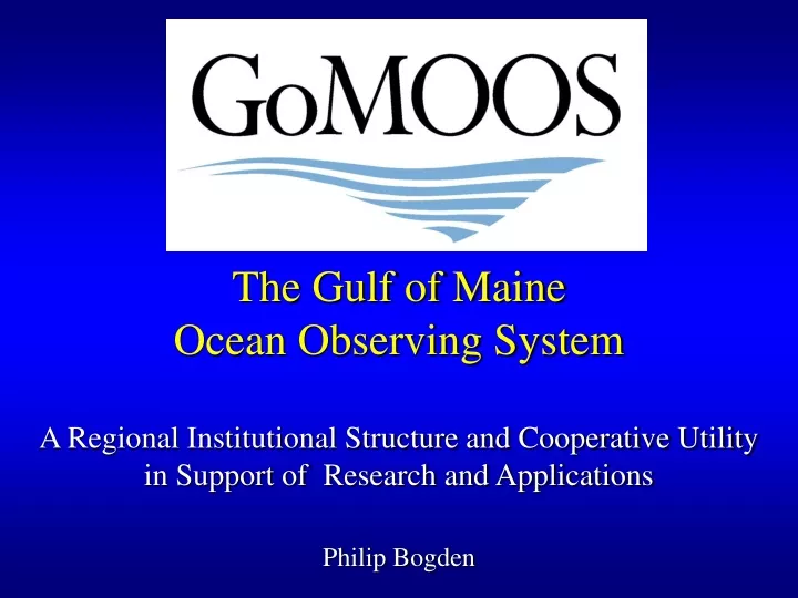
A Cooperative Utility
270 likes | 294 Views
Explore the regional structure and benefits of the Gulf of Maine Ocean Observing System supporting real-time monitoring of weather, oceanic conditions, and environmental quality for varied user sectors. Discover the cooperative utility's collaborative efforts in research and applications across institutions and industries.

A Cooperative Utility
E N D
Presentation Transcript
The Gulf of Maine Ocean Observing SystemA Regional Institutional Structure and Cooperative Utilityin Support of Research and ApplicationsPhilip Bogden
A Cooperative Utility Serving the Gulf of Maine: Nova Scotia, New Brunswick, Maine, New Hampshire, Massachusetts. Including: • Marine industries • Research institutions • Government agencies • Educational institutions • Private companies • Nonprofits
Technical Program Real time monitoring and prediction of: • Weather - surface ocean winds, air temperature, visibility. • Oceanic conditions - currents, waves, temperature, salinity, density. • Environmental quality - water clarity, turbidity, nutrients, dissolved oxygen. • Ocean biology - algal biomass, productivity, community structure.
Bedford Institute of Oceanography (DFO) Peter Smith & William Perrie – Wave modeling Bigelow Laboratory for Ocean Sciences Collin Roesler – Phytoplankton and bio-optics University of Maine Neal Pettigrew (Chief Scientist): Buoys & Currents David Townsend – Nutrients Andrew Thomas – Satellite remote sensing Huijie Xue – Circulation modeling University of Southern Maine Lewis Incze – Upper trophic levels Woods Hole Oceanographic Institution James Irish – Moorings & wave measurements And growing: Cornell, Univ. of New Hampshire,… Science Team
Corporate Model • Incorporated as a nonprofit entity, 501(c)3 • Clearly defined mission as a service utility • Governed by Board of Directors w/By-Laws • Membership organization with dues • Members come from all user sectors • Board of Directors drawn from membership • Small staff (CEO + 2.6 support) • Data management (2.5 programmers) • Identifying & responding to user needs
Membership Private Sector: Durand & Anastas Environmental Strategies Horizon Marine, Inc. Nobska Development Corporation OEA Technologies RD Instruments, Inc. Satlantic, Inc. Marine Industry: Atlantic Pilotage Authority Bath Iron Works Eastport Port Authority Federal Marine Terminals Penobscot Bay & River Pilots Assn. Portland Pipe Line Corporation Maine Lobstermen’s Association Massachusetts Lobstermen’s Association Saint John Marine Pilots Saint John Port Authority Nonprofit: Gulf of Maine Research Institute Island Institute New England Aquarium
Membership, cont. Research & Education: Bigelow Laboratory for Ocean Science Bowdoin College Dalhousie University Maine Maritime Academy MIT Sea Grant Rutgers University University of Maine University of Massachusetts University of New England University of New Hampshire University of Rhode Island Woods Hole Oceanographic Institution Government: Bedford Institute of Oceanography (DFO) Maine Dept. of Marine Resources Maine State Planning Office Mass. Office of Coastal Zone Management Mass. Water Resources Authority NOAA National Marine Fisheries Service NOAA National Undersea Research Center NOAA Stellwagen Bank National Marine Sanctuary U.S. Geological Survey
National Backbone • Satellite remote sensing • In situ sensing • reference & sentinel • station-network • Link to global ocean • component • Data standards & • exchange protocols National Federation of Regional Systems • Regional Systems • Regional priorities • Effects of climate change • & Effects of land-based • sources • Resolution, • Variables
What’s going on in the Gulf of Maine? • Institutional Issues • Gulf of Maine Regional Association • Gulf of Maine Data Partnership • Technical Issues • Data Management & Communications (DMAC) • Data Partnership Work Plan • Discoverable, Authoritative, Accessible & Accommodating • Marine Metadata Interoperability (MMI) Initiative • Environmental B2B2C and the Semantic Web…?
Vision: Global Earth Observing System of Systems (GEOSS) 3-Legged Stool: 1. Federal & State Agencies 2. Private Sector 3. Research Community
Leading by Example… OpenIOOS Interoperability Test Bed: 1. NOAA Coastal Services Center + other Feds 2. Private Sector (not so much…yet) 3. SURA Universities + GoMOOS + many others …Working Together to Define Interoperability
www.OpenIOOS.org Contributors: NASA, NOAA, Navy, USGS, Various regional programs and their many research university partners
OpenIOOS Interoperability Test Bed What’s remarkable about it? • Fully distributed • Standards enabling innovation (standardizing interfaces for modules) • Interoperability independent of technology (encourages private-sector) • Open Geospatial Consortium (GIS-access nurtures practical use) • Modern & forward thinking: WWW = HTTP + HTML Web Services • Feds and Researchers interoperating with IT • A virtual community sharing data with Open Standards • Advancing the science of environmental prediction & hazard planning • Enabling transition from research to operations
GoMOOS Data PartnershipsEnabling the “Regional Association” with IT • GoMMaP – Gulf of Maine Mapping Portal • Standards enabling innovation • OpenIOOS • Putting the “I” in IOOS • Gulfwatch • Contaminant monitoring with mussels • Northern Shrimp • Ecosystem-based management? (Not yet.)
SURA Objectives • Build Community Support • Work the Data Standards Problem(s) Help create the language of interoperability Break down the stovepipes • Demonstrate a “Data Grid” Distributed data sharing, integration & visualization Interoperability a la OGC (www.OpenIOOS.org) • Develop a “Model Grid” Grid middleware & data management for real-time prediction, Modular and standardized to enable broad access
Distributed Prediction Architecture Standardize encapsulation & transport over Internet/NLR Data Providers Prediction Systems System Services NASA Meteorological Prediction Systems Data Discovery NOAA Data & Archive Services USGS Tide, Surge and Wave Prediction Applications SEACOOS Planning GCOOS Innovative Research Programs Decision Support Tools University Programs Standardize module interfaces (servers & clients)