Download
1 / 48
480 likes | 511 Views
Discover the physical geography, climates, and resources of Atlantic South America. Learn about major landforms, rivers, climates, and human impact on the environment. Explore Brazil, Argentina, the Amazon, and more.

E N D
Chapter 16Atlantic South America 6th Grade Social Studies Hodnicki
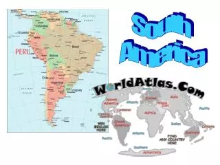
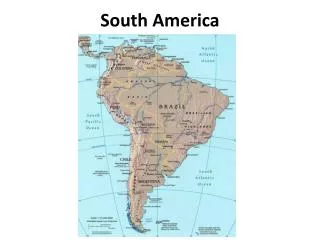
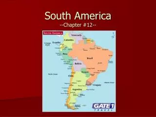
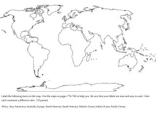
Maps of South America Political Physical
Amazon River / Basin Brazilian Highlands Brazilian Plateau Gran Chaco Patagonia Andes Parana River Paraguay River Rio de la Plata Tierra del Fuego Section 1: Physical Geography South America Map
Section 1 Objectives • Identify the landforms and rivers found in Atlantic South America. • Describe the region’s climates, vegetation, and wildlife. • Name some of the region’s important resources.
Section 1: Vocabulary • Pampas - A wide, grassy plains region in central Argentina • Estuary - A partially enclosed body of water where salty seawater and freshwater mix • Soil exhaustion - The loss of soil nutrients needed by plants
Questions • What are the region’s major landforms and rivers? • What are the climates of the region? • How have humans modified the region’s environment? 4:37
SECTION 1 Physical Geography Question: What are some of the important natural resources of Atlantic South America?
SECTION 1 Physical Geography Resources of Atlantic South America Area of Atlantic South America Resource rain forest—for food, wood, rubber, medicinal plants; gold, other minerals Amazon River basin Brazilian Highlands oil Brazilian Plateau hydroelectric power; minerals Gran Chaco hydroelectric power Pampas oil, natural gas, minerals Patagonia oil, natural gas
Main Ideas • What major landforms lie between the Amazon River basin and Patagonia? • The Brazilian Highlands, the Pampas, and Gran Chaco are the major landforms that lie between the Amazon River and Patagonia.
Main Idea • What sets the Amazon River apart from all of the world’s other rivers? • The Amazon River drains the largest area and carries more water than any other river in the world.
Main Idea • Why is the Patagonia desert dry? • The Patagonia is dry because the Andes prevent the Pacific Ocean’s rain-bearing storms from reaching the area.
Tropical Rainforests:Where Are Rainforests Located? • Tropical rainforests are located near the equator • One third of the world's tropical rainforests are in Brazil.
What makes the Tropical Rainforest special? • Forest People • Causes of Destruction • Worksheet • Video and Quiz to follow
Rainforest 27:00
Section 2 Objectives • Describe the history of Brazil. • Identify the important characteristics of Brazil’s people and culture. • Describe what Brazil’s four major regions are like today.
Brazil • Vocabulary • Favelas – huge slums that surround some Brazilian cities
Questions • How have different people influenced Brazilian history? • How has cultural borrowing affected Brazilian culture? • What are Brazils four main regions? 4:51
SECTION 2 Brazil Question: What are some important characteristics of Brazil’s various regions?
SECTION 2 Brazil Brazil The Amazon dense rain forest; isolated Brazilian Indian villages; Manaus—major city; Belém—Atlantic port; large mining district; tensions among Brazilian Indians, settlers, miners The Northeast old colonial cities like Salvador, suffers from drought, poorest region, favelas The Interior savannas and dry woodlands, could become agricultural area, Brasília, the national capital The Southeast coffee-growing area, Rio de Janeiro, richest region, most people, São Paulo
Main Ideas • From what major immigrant groups are many Brazilians descended? • Many Brazilians are descended from Africans, Portuguese, Spaniards, Germans, and Italians, and Poles.
Main Idea • What is Brazil’s poorest region? What is its richest and most populated region? • Brazil’s poorest region is the northeast and its richest and most populated is the southeast.
Google Earth • Brazil • Brasilia • Manaurs • Argentina • Cordoba • Cosquin
Brazil 20:21
Section 3 Objectives • Describe the history of Argentina. • Identify the important characteristics of Argentina’s people and culture. • Describe what Argentina is like today.
Section 3: Argentina • Vocabulary: • Encomienda - A system in which Spanish monarchs gave land to Spanish colonists in the Americas; landowners could force Indians living there to work the land • Gauchos - Argentine cowboys • Mercosur - A trade organization that includes Argentina, Brazil, Paraguay, Uruguay, and two associate members (Bolivia and Chile)
Questions • How was Argentina’s government organized during much of the 1900s? • Why are so many languages spoken in Argentina? • What is Argentina like today? 3:54
SECTION 3 Argentina Question: What is the ethnic makeup of Argentina’s population?
SECTION 3 Argentina Ethnic makeup of Argentina Descendants of Spanish, Italian, or other European settlers 97% Argentine Indians and mestizos 3%
Main Ideas • What happened to Argentine Indians in the Pampas in the 1800s? How did that affect Argentine society? • Argentine Indians were killed in wars with the Argentine government. There are few Indians today.
Main Idea • Where is much of Argentina’s industry located? Why? • Most of Argentina’s industry is located in the Buenos Aires area because of its beneficial position in the country.
Argentina 2:49
Buenos Aires • Locate Buenos Aires • Where is Buenos Aires located? • What would you expect to find in Buenos Aires? (notebook) • Lets go to Buenos Aires (Google Earth)
Section 4 Objectives • Describe what the people and economy of Uruguay are like today. • Describe what the people and economy of Paraguay are like today.
Section 4: Uruguay and Paraguay • Vocabulary • Landlocked - Completely surrounded by land, with no direct access to the ocean
Questions • What geographic factors support agriculture in Uruguay? • How is Paraguay’s economy organized? 4:00
Paraguay and Uraguay 20:03
SECTION 4 Uruguay and Paraguay Question: In what ways do the people and economies of Paraguay and Uruguay differ?
SECTION 4 Uruguay Paraguay People People Economy Economy Uruguay and Paraguay The People and Economy of Paraguay and Uruguay 95% mestizo; Spanish (lang.), Guaraní, most Roman Catholic 88% European; most Roman Catholic; Spanish, Portuguese (lang.) ; 90% urban; high literacy rate controlled by few families and companies; surplus hydroelectricity; agriculture; not much industry led by Brazil and Argentina; agriculture, livestock; hydroelectric power
Main Ideas • When and from what country did Uruguay win independence? What about Paraguay? • Uruguay gained independence from Spain in 1825 and Paraguay from Spain in 1811.
Main Idea • Where is Paraguay’s most productive agricultural land? • Paraguay’s most productive land is located east of the Paraguay River.
Main Idea • How has Paraguay used the natural resources for economic development? • Paraguay has erected hydroelectric projects on the Parana River to create more power, surplus power is sold to Brazil and Argentina.
CHAPTER 16 Chapter Wrap-Up 1. Which country in Atlantic South America was a Portuguese colony? What colonial power controlled the other countries before they became independent? 2. What major river systems drain much of northern and central Atlantic South America? What economic roles do they play? 3. Which is the richest region in Brazil? Which is the poorest? 4. What and where is the Rio de la Plata? 5. What is the most important agricultural area in Argentina?
Review • Jeopardy Game
Credits • All information and activities borrowed from Holt, Rinehart, and Winston; People, Places, and Change