WISE 2.0
WISE 2.0. WISE technical developments and data exchange at EEA including ARC GIS and viewers (overview ) Starting from a gap analysis. Gap analysis – current state. A detailed review of all data models was not possible in this short time but this will be the next step

WISE 2.0
E N D
Presentation Transcript
WISE 2.0 WISE technical developments and data exchange at EEA including ARC GIS and viewers (overview) Starting from a gap analysis Event/ date: WISE TG Copenhagen 2014/04/28 Author: Olaf Büttner, Beate Werner
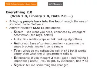
Gap analysis – currentstate • A detailed review of all data models was not possible in this short time but this will be the next step • Marine data will be part of the review Someremarks: • The analysisis still in progress • mainly based on a short term (roughly two-month) review of WISE consisting of • discussions with EEA staff (mainly colleagues from IT and systems departments) • Discussions with ETC data managers • Second Implementation Plan of WISE 2011 – 2015 • Rolling work plan WISE development 2nd generation (Version 2.0, October 2013) • Installation of SoE data (waterbase) and WFD data (Atkins) on a common (local) platform (Oracle SQL)
WISE – everythingisconnected II pilots IV Inspire compliance Arc GIS viewer SIIFUWWTDStefan/Bo&WFD SDI III ? NiDi ?? DW ? SoEriv./lake SoEquantity SoEemission UWWTD BaWa WFD Solution for common data space- Snapshot for viewer QA/QC tools Arc GIS Online ? I ECRINS 1.5 Adaptation started (Marek/Mauro) MIgrate ARC GIS Working data base/partly manual QA/QC – ETC ICM ARC GIS Working data base/partly manual QA/QC – ENV – UBA Vienna – to EEA Data-viewer ARC GIS Working data base/partly manual QA/QC –ETC ICM TC Vode ECRINS v 1.1 Data-viewer Working data base/partly manual QA/QC – Atkins to EEA Flex-viewer to ARC GIS
Gap analysis - outline The paper will follow thisoutline • What are the questions that can’t be answered with current WISE or why do we need WISE 2.0? • Example: Linkage between Nitrate directive data and diffusive SOE data (in detail by Peter) • What are the main obstacles for answering integrated questions with WISE – gap analysis • Information is scattered and cannot easy be connected • First recommendations and next steps • Common workspace for different data (short presentation of the idea)
WISE implementation plan - I • QA/QC - WFD is complex - Reportnet yes again, but develops more flexiblility (SørenRoug)- Eionet / directives not integrated • SIIF/ distributed system partly mentioned – developed further (ENV, next presentation) • Common work space for interoperability and targeted access (new) • Functions for remote access, download and targeted retrieval • Arc GIS – updated technology (session III) • INSPIRE compliance to be further worked on for all directives (session IV)
Identifiedgaps QA/QC procedures in Reportnetshouldbeimpovedfor WFD reporting (SørenRoug) Reporting formatsfor GIS datashouldbediscussed (shapesvs.GML: session III, Andres Bastholm-Stæhr) Coding, uniqueidentifiersandbetterqualityassuranceof GIS information Technical implicationsfor progressreporting Tracking ofchanges in WB deliniations (session III, NiklasHolmgren) Streamliningof SOER dataflowsand WFD dataflow Event/ date: WISE TG Copenhagen 2014/04/28 Author: Olaf Büttner, Beate Werner
Improved system architecture:common workspace WISE system development – using and developing EEA infrastructure from the content perspective WaterbaseSpatialdatasets SoE Marine MSFD data SoE Rivers WFD data SoELakes EU-WB-ID Other directives SoE GW SoEEmissions Wateraccounting, ECRINS EEA Server withcommonworkspace (CWS) EEA CWS isembedded in WISE
Working together on the same workflow modules: Reportnet SQL Server ArcGIS FME Validation scripts Further newmodules Developing EEA Products: multiple teams and groups work together teams: different people with different skills that can handle and link all these modules Event/ date: WISE TG Copenhagen 2014/04/28 Author: Olaf Büttner, Beate Werner
Improved system architecture:common workspace Advantages of a commonworkspace Stepforwardto a commondatastructureforinformationpertainingto all waterdirectives Enablingcross-cuttingassessmentsofclimatechange, landuse, andbiodiversity Cross-assessmentsofthe UWWTD, Nitrates directiveandtheBaWadirective StreamliningSoEand WFD data Providing the same datafor all WISE products: maps, datasets, graphs Update ofdataisimmediatelyavailablefor all products Event/ date: WISE SG Brussels 2014/03/31 Author: Olaf Büttner, Beate Werner
VisualizationwithArcGis Online Centralized EEA-SDI / Decentralized management web dissemination ETCBiodiversity ETCAir ETCClimate Change publish publish ETCJRC/DG Mare publish ETC ICMInland, Coastal, Marine Water ETCSpatial information and Analysis Slide by Jan Bliki, EEA
Components tree Web application(template) Web application(configuration) Web application(configuration) Web applications Web map(configuration) Web map(configuration) Web map(configuration) Web map(configuration) Web maps Web-service(map service) Web-service(tiled service) Web-service(processing service) Web-service(feature service) Web-service(image service) Web-services Map for Office(Excel) Map document(Mosaic Dataset) Map document(ArcMap) Map document(ArcMap) Map document(ArcGis Toolbox) Desktop Event/ date: WISE SG Brussels 2014/03/31 Author: Olaf Büttner, Beate Werner Slide by Jan Bliki, EEA
VisualizationwithArcGis Online • DensityofSoEstations (nutrientsandhazardoussubstances) reportedfromItalyand Germany (preparationofcountryfichesfortheEIONET workshop)
VisualizationwithArcGis Online Web Map Service Web featureservice • Expert mapscanbecreated in the EEA environment • The Web featureservicescanbeusedbyother Web maps
ArcGIS online from a userperspectivetomorrow, session III Bruno Rakedjian Event/ date: Author:
Thankyouforyourattention! Event/ date: Author:
VisualizationwithArcGis Online • Thereare lots ofmapandfeatureservicesavailable • The onlydifficultyisto find therightoneforownpurpose quick …
Selected EEA productsfromthe AWP 2014 Support from ETC isreflected in thetask plan • WISE upgrade • maintenance and review of all data bases, converging SOE and directives (WFD, …) • Improved system architecture • Improved visualisation Event/ date: WISE TG Copenhagen 2014/04/28 Author: Olaf Büttner, Beate Werner
Example: WFD data; easy visualizationof different contentdatawithArcGiS Online Ecological Status Surface Water Bodies Protected Area Status Chemical Status • Understand the database structure • Denormalization of the SWB database Event/ date: WISE SG Brussels 2014/03/31 Author: Olaf Büttner, Beate Werner
Improved system architecture: common workspace ECRINS/EU Hydro Working database Outside EEA, Atkins (MS SQLServer) • WISE system development – using and developing EEA infrastructure from the content perspective Waterbase Spatialdatasets ArcGIS Online Working databases EEA QA/QC Itisbynomeans easy toaccessand/orassessdatafrom different datasets, althoughtheymaybecontentrelated. At least a partofthemhave a commonspatialreference. A way out wouldbe a commonworkspacefor all data, accessibleforuserswithgrantedrights. WFD dataset (Access, CSV, …) Waterbase SoEdatasets (Access, CSV) Other directives (MSFW,UWWTD, BaWa, DW, ND,…) COM EEA ETC Consultants … Reportnet