Hurricane Research from the ISS
160 likes | 309 Views
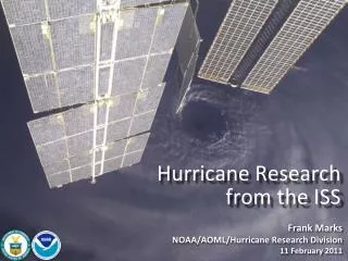
Hurricane Research from the ISS. Frank Marks NOAA/AOML/Hurricane Research Division 11 February 2011. Goals Improve Forecast Accuracy Hurricane impact areas (track) – 50% in 10 years Severity (intensity) – 50% in 10 years Storm surge impact locations and severity

Hurricane Research from the ISS
E N D
Presentation Transcript
Hurricane Research from the ISS Frank Marks NOAA/AOML/Hurricane Research Division 11 February 2011
Goals • Improve Forecast Accuracy • Hurricane impact areas (track) – 50% in 10 years • Severity (intensity) – 50% in 10 years • Storm surge impact locations and severity • Extend forecast reliability out to 7 days • Quantify, bound and reduce forecast uncertainty to enable risk management decisions
Current Capabilities:Statistical-dynamical models • Statistical-dynamical models (SHIPS, LGEM, & RI-index) are skillful sources of intensity guidance primarily from global models • SHIPS & LGEM contain ~55-60% of the variance in intensity change, RI-Index ~30% of RI variance, primarily from large-scale in GFS. • Until regional models improve there is value in improving statistical- dynamical approaches.
HFIP Activities • Traditional Hurricane Research Activities: • Observations, analysis, database, & instrument R&D (IFEX) • Statistical-dynamical model development • Advances in operational models (Stream 1) • New HFIP Research Thrusts: • Experimental global and regional hurricane model development (Stream 2) • Data assimilation techniques and observing system strategy analysis development (Stream 1 & 2) • Model evaluation tool development • Socioeconomic research and development D1 D2 Partnership: NCEP, AOC, AOML, ESRL, GFDL, DTC, USWRP, NESDIS/STAR
Current CapabilitiesGlobal Model – Ensembles Tomas (21L) – init 00Z 2 November http://ruc.noaa.gov/hfip/gfsenkf GFS Courtesy of Tom Hamill & Jeff Whitaker (ESRL)
Current CapabilitiesGlobal Model – Ensembles http://ruc.noaa.gov/hfip/gfsenkf Courtesy of Tom Hamill & Jeff Whitaker (ESRL)
Current CapabilitiesGlobal Model – Ensembles Shary Tomas Courtesy of Stan Benjamin & Mike Fiorino (ESRL)
Current CapabilitiesGlobal Model – Ensembles Courtesy of Stan Benjamin & Mike Fiorino (ESRL)
Current CapabilitiesGlobal Model – Ensembles Tomas (21L) – init 00Z 2 November http://ruc.noaa.gov/hfip/gfsenkf GFS Courtesy of Tom Hamill & Jeff Whitaker (ESRL)
Track Issues • Sensitivity to environmental circulation beyond TC envelope • Environment wind and thermodynamic structure through targeted observations (dropsondes) and satellite radiances. • Issues include: • poor data coverage in important areas, • inability to cover necessary targets • temporal and spatial resolution (24 h, horizontal >100 km, integrated or limited vertical resolution)
Intensity Issues • Sensitive to environmental circulation beyond TC envelope (shear, eddy flux, etc.) • Sensitive to boundary conditions, interactions, and changes along track • Sensitive to inner core dynamics • Sampling limited by presence of heavy rain, clouds, strong winds. • Issues include: • poor data coverage in important areas, • temporal & spatial resolution (3-6 h, 5-10 km horizontal, 1 km vertical)
ISS Good coverage of global tropics and TC basins (15-16 orbits/day) • Inclination: 51.6° • Altitude: 350 km • Revolutions/Day: 15.7
How can ISS DWL help? • Track: • provide regularly spaced data coverage in important areas surrounding TC for data assimilation into numerical models. • Need temporal resolution at least 24 h, horizontal resolution of 250 km, and vertical resolution of 1 km. • Accuracy to better than 1 m s-1 for mean wind surrounding TC - 1 m s-1 error in mean wind yields 86.4 km track error in 24 h.
How can ISS DWL help? • Intensity (beyond those above): • improved vertical structure of environment surrounding and above core, particularly near the tropopause for use in determining shear, divergence, and eddy flux. • higher temporal resolution 12 h, horizontal resolution 25 km, vertical resolution <1 km. • Accuracy to 1 m s-1 for vertical shear in vicinity of TC - large differences in storm intensity change for small changes in vertical shear.
Summary • ISS DWL can have great impact on TC forecasts and research through improved horizontal and vertical wind structure in environment immediately surrounding storm. • DWL does not need to provide data in core for major impact. • Major advantages: • better temporal & spatial wind coverage surrounding TC than currently possible with targeted obs and satellite radiances. • higher vertical resolution especially useful near top and bottom of environment • improved accuracy of wind estimates


![[The Hurricane]](https://cdn1.slideserve.com/1952424/the-hurricane-dt.jpg)