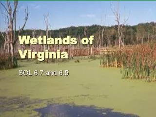
Understanding Wetlands in West Virginia: Save Our Streams Program
170 likes | 271 Views
Learn about wetlands in West Virginia, their soils, hydrology, vegetation, and classification. Discover the functions, values, statistics, and importance of wetlands in biodiversity conservation efforts.

Understanding Wetlands in West Virginia: Save Our Streams Program
E N D
Presentation Transcript
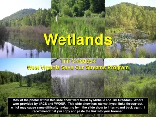
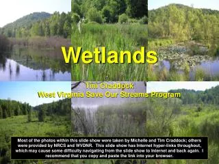
WetlandsTim CraddockWest Virginia Save Our Streams Program Most of the photos within this slide show were taken by Michelle and Tim Craddock; others were provided by NRCS and WVDNR. This slide show has Internet hyper-links throughout, which may cause some difficulty navigating from the slide show to Internet and back again. I recommend that you copy and paste the link into your browser.
What are Wetlands? Wetlands are transitional ecosystems between terrestrial and aquatic habitats where the water table is usually at or near the surface or the land is covered by shallow water. For purposes of classification, wetlands must have the following attributes At least periodically, the land supports predominantly hydrophytes; The substrate is mostly un-drained hydric soil; and The substrate is non-soil and is saturated with water or covered by shallow water at some time during the growing season of each year.
Wetland Soils Most wetland soils have reduced oxygen levels, which give the soils particular characteristics. • Gleyed or mottled • Accumulation of organic matter • Oxidized root channels • Smell of rotten eggs (hydrogen sulfide) http://www.dnr.wa.gov/htdocs/lm/field_guides/recognizing/soils.html
Wetland Hydrology The water must be at or near the surface at least two weeks during the growing season. T. Craddock Your Text Here http://www.dnr.wa.gov/htdocs/lm/field_guides/recognizing/hydrology.html
Wetland Vegetation Plants that occur in wetland environments are known as hydrophytes. These plants are classified according to their probability of occurrence. Several of these classification terms are described below. Obligate Wetland Plants (OBL): Plants with a high probability (> 99%) of occurring in wetlands under natural conditions. Facultative Wetland Plants (FACW): Plants that usually occur (67-99%) in wetlands under natural conditions. Facultative Plants (FAC): Plants that sometimes occur (33-67%) in wetland environments under natural conditions. For additional codes and definitions visit the Natural Resource Conservation Service’s Plant Database: http://plants.usda.gov/wetinfo.html
Your Text Here http://www.npwrc.usgs.gov/resource/wetlands/classwet/index.htm
Broad Category Classification Riverine wetlands are found in a valley or adjacent to a stream channel. They lie in the active floodplain of a river or stream and have important links to the water dynamics of the river system. Lacustrine wetlands are associated with deep water habitats with the following characteristics: situated in a topographic depression or a dammed river channel; lacking trees, shrubs, and other persistent emergent's; total area exceeds 20 acres. Non-tidal wetlands substantially covered by emergent's, trees, shrubs, moss/lichens, etc. Total area is less than 20 acres. Most bogs, swamps, marshes and wet meadows fall into this category. Lacustrine Riverine Palustrine
Classification by Wetland Types 1. Swamp foresthttp://www.epa.gov/owow/wetlands/types/bottomland.html 2. Shrub swamp http://www.epa.gov/owow/wetlands/types/swamp.html#shrub 3. Marsh http://www.epa.gov/owow/wetlands/types/marsh.html 4. Wet Meadow http://www.epa.gov/owow/wetlands/types/wmeadows.html 5. Bog/Fen http://www.epa.gov/owow/wetlands/types/bog.html 6. Vernal pools http://www.epa.gov/owow/wetlands/types/vernal.html http://www.nature.org/wherewework/northamerica/states/illinois/preserves/art1124.html
Wetland Functions and Values High Productivity: Biomass per unit area is often the highest of any ecological community Habitat Diversity Flood Control Groundwater Recharge Filtration of Nutrients Recreation Agricultural Uses Fisheries Rare and Endangered Species http://www.epa.gov/watertrain/wetlands/
Wetland Statistics in West Virginia Occur in less than 1% of the state’s surface area; thought to have lost about 25% since colonization by Europeans (may be higher). Nationally wetland loss has been greater than 50%. http://www.nmfs.noaa.gov/habitat/habitatconservation/publications/habitatconections/num5.htm
FACW wetland plants make up a whopping 44% (187 of 471 species) of the rare, threatened, and endangered species that are tracked by the West Virginia Natural Heritage Program. West Virginia also lies in an area of great species richness for rare taxa. The whole state is important in terms of bio-diversity, and our wetlands are the jewels in the crown. Elizabeth Byers, WVDNR Ecologist http://www.wvdnr.gov/Wildlife/Wildlife.shtm
How do we determine the extent of our wetland areas? The US Fish and Wildlife Service uses remote sensing technologies through aerial photography to locate probably wetland areas. The various hues produced by these pictures allowed USFWS to establish signatures for the wetlands. The areas are generally outlined on a 1/24,000 scale USGS topographic map. USEWS Wetland Geodatabase: http://wetlandsfws.er.usgs.gov/NWI/index.html
Can you delineate the wetland area? Aerial view of Pine Swamp http://www.merriam-webster.com/dictionary/delineate http://www.mountainzone.com/mountains/detail.asp?fid=4095956
The green line shows the approximate wetland boundary within the aerial view.
Wetland Regulations The Clean Water Act regulates the polluting of national waterways, which includes wetlands. Section 404 Permit Requirements: Wetlands from 1/10th to ½ acre may need a dredge and fill permit; the US Army Corps of Engineers is the regulating entity for national permits. State 401 Certifications: A permit is required to fill a wetland greater than ½ acre. http://www.wetlands.com/regs/tlpge02a.htm http://www.wetlands.com/regs/sec404fc.htm http://www.wetlands.com/regs/sec401fc.htm
Wetlands Are Wonderful Your Text Here For more information go to: http://www.epa.gov/wetlands/. The next slide provides a variety of resources from the Internet for further reading.
Additional Resources • http://el.erdc.usace.army.mil/wetlands/pdfs/wrpde11.pdf • http://www.wetlands.com/regs/tlpge02e.htm • http://www.epa.gov/owow/wetlands/pdf/wetwalk.pdf • http://www.epa.gov/OWOW/wetlands/facts/contents.html • http://www.epa.gov/region01/students/teacher/world.html • http://www.epa.gov/owow/restore/ • http://www.fws.gov/nwi/index.html • http://www.chesapeakebay.net/wetlds1.htm • http://www.wetlands.com/regs/tlpge00a.htm • http://www.wvdnr.gov/publications/PDFFiles/High%20Allegheny%20Wetlands-web.pdf • http://www.anr.state.vt.us/dec/waterq/wetlands/docs/wl_factsheet2.pdf • http://forest.mtu.edu/classes/fw4220/wetlands/deq-water-wetlands-idmanualchap2.pdf • http://www.sws.org/education/ • http://www.sws.org/index.mgi • http://www.wetlandswatch.org/wet_facts.asp • http://www.dnr.wa.gov/htdocs/lm/field_guides/recognizing/glossary.html • http://www.wetland.org/