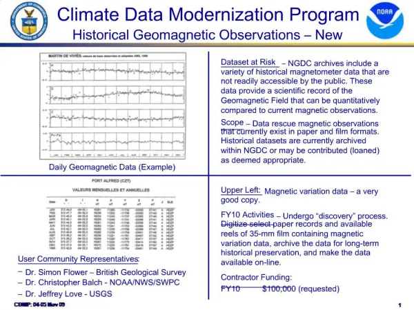
U.S. Climate Reference Network Overview and Historical Climate Network Modernization
290 likes | 444 Views
U.S. Climate Reference Network Overview and Historical Climate Network Modernization. Michael Palecki National Climatic Data Center Asheville, NC. Standard USCRN/USHCN-M site installation. Sites are selected in stable, rural locations Instruments calibrated to NIST standards

U.S. Climate Reference Network Overview and Historical Climate Network Modernization
E N D
Presentation Transcript
U.S. Climate Reference Network Overview and Historical Climate Network Modernization Michael Palecki National Climatic Data Center Asheville, NC
Standard USCRN/USHCN-Msite installation • Sites are selected in stable, rural locations • Instruments calibrated to NIST standards • Triplicate configurationfor temperature & precipitation measurements • internal consistency assures quality • redundancy protects continuity • Ancillary measurements support primary at USCRN stations • global solar, surface IR temperature, low-level wind, and wetness
The Basics: How USCRN/USHCN-M Work • Primary variables are measured with triplicate configurations that allow for intercomparisons: • 3 PRTs measure T • 3 wires measure P Grand Teton CRN Station Triplicate Temperature Sensors
Typical Instruments at USCRN Sites Relative Humidity Soil Moisture and Temperature
4 Projects in Progress Core USCRN program of station maintenance, data collection/distribution, and climate science Deployment of soil moisture / temperature probes and RH instruments across the USCRN network in cooperation with the National Integrated Drought Information System (NIDIS) program Build-out of the USCRN in Alaska over the next 5 years and collaboration with GCOS in placing instruments in underrepresented areas USHCN-M build-out in the Southwest (AZ,CO,NM,UT) and expansion to national program
Core USCRN Progress – FY10 • Improvement of USCRN Software Infrastructure • Completion of new station monitoring system for network • Improvement of USCRN Web site • Many underlying improvements • New soil moisture visualizations, soon new solar products • Expansion of Science • Two USCRN research associates will be hired Autumn 2010 • USCRN temperature data from 2004-2008 used to confirm the reliability of USHCN v.2 national temperature departures
U.S. Historical Climatology Network v.2 Menne, M.J., Williams, Jr., C.N., and Palecki, M.A., 2010. On the reliability of the U.S. surface temperature record. J. Geophys. Res., 115, D11108, doi:10.1029/2009JD013094.
USCRN Soil Moisture and Temperature • Workshop on March 3-5, 2009, brought together 25 national experts on soil climate measurements and their applications • Critical advice: • Placement of three separate sets of SM/ST probes in three plots around each station location • Selection of 5, 10, 20, 50, 100 cm depth levels • Installation procedures, sampling, QA/QC • Identification of soil sampling and soil metadata needs • Involvement in community test beds and satellite cal/val
Crossville, TN, first official USCRN installation of soil probes, April 2009 Engineering, installation, and maintenance by USCRN partners at Oak Ridge, TN, the Atmospheric Turbulence and Diffusion Division, NOAA/OAR/ARL.
USCRN Soil Moisture Network Status of Soil Moisture/Soil Temperature Sensors at USCRN Stations as of August 24, 2010 ME Limestone WA Darrington WA Quinault MT St. Mary ND Northgate WA Spokane MN Goodridge ME Old Town MT Wolf Point ND Jamestown MI Chatham ND Medora MN Sandstone OR Corvallis MT Lewistown MT Dillon NH Durham OR John Day SD Aberdeen MI Gaylord SD Buffalo NY Ithaca RI Kingston ID Murphy NY Millbrook WY Moose OR Coos Bay OR Riley WI Necedah ID Arco SD Pierre WY Sundance SD Sioux Falls NV Denio WY Lander CA Redding PA Avondale NE Harrison IA Prairie City IL Shabonna NE Whitman UT Brigham City OH Coshocton CA Bodega CO Nunn CO Dinosaur WV Elkins IN Bedford NE Lincoln IL Champaign NV Baker VA Cape Charles CA Yosemite VA Charlottesville MO Chillicothe CO Boulder KS Oakley CO Montrose UT Torrey CA Merced KS Manhattan KY Versailles CO La Junta KY Bowling Green CO Cortez NV Mercury MO Joplin MO Salem NC Durham CA Stovepipe Wells CA Santa Barbara NC Asheville TN Crossville AZ Williams OK Goodwell NM Los Alamos AR Batesville GA Watkinsville OK Stillwater SC Blackville CA Fallbrook MS Holly Springs AL Gadsden NM Socorro SC McClellanville AZ Tucson TX Muleshoe AZ Yuma NM Las Cruces AL Selma AZ Elgin LA Monroe MS Newton GA Brunswick TX Bronte GA Newton TX Monahans TX Palestine AL Fairhope LA Lafayette TX Austin FL Titusville TX Panther Junction 15 Probes & RH installed FL Sebring TX Port Aransas 6 Probes & RH installed FL Everglades RH only installed TX Edinburg Online data availability will expand gradually this autumn after next generation QA/QC system is completed
Shift in USDM status at Watkinsville, GA USDMAug 11 USDMSep 22
QC Issues - Variability Between Plots Even within a 7 meter distance, soil characteristics vary Between sensor comparison is not straightforward, and will not be part of initial QC suite
USCRN Soil Moisture Visualization http://www.ncdc.noaa.gov/crn/visualizations.html
USCRN in Alaska Barrow Red Dog Mine Fairbanks Tetlin NWR Port Alsworth Kenai NWR Yakutat Sitka St. Paul Is. Sand Point Alaska • 2009 installations at Port Alsworth and Sand Point will be commissioned by September 2010 • 2010 installations took place at Red Dog Mine and Kenai NWR • More surveys were done this summer for FY11 installs
USCRN Alaska Sites: St. Paul Island
USCRN Issues at Barrow Barrow SDFIR and gauge set too low to ground first year Polar Bear Hug
Regional Resolution Network Name now: U.S. Historical Climatology Network Modernization (USHCN-M) Name in FY12: Regional U.S. Historical Climatology Network (RUSHCN) Goal: To detect climate trends in the 9 U.S. climate regions as small at 0.5°C/century in temperatures and 10%/century in precipitation Progress: Deployment in Southwest is underway, with 60 new stations installed by the end of FY10
More Data Access • Web Site improvements are ongoing • http://www.ncdc.noaa.gov/crn/ • Hourly and daily data available in bulk by ftp • ftp://ftp.ncdc.noaa.gov/pub/data/uscrn/products/hourly02/ • ftp://ftp.ncdc.noaa.gov/pub/data/uscrn/products/daily01/ • ftp://ftp.ncdc.noaa.gov/pub/data/uscrn/products/soilsip01/ • Additional data visualizations coming soon
USCRN/USHCN-M: Meeting the Needs of Climate Stakeholders in the United States • Accurate, real time, climate science quality observations of temperature, precipitation, and soil moisture/temperature with USCRN • Unique triplicate measurement approach • Primary climate change detection mission continues • Operational mission expands (weather prediction, drought monitoring, agriculture) • Science mission expands (satellite calibration/ validation, soil moisture modeling, soil moisture/ temperature trend detection)