Download
1 / 7
70 likes | 190 Views
A proposal to measure transport variations between the Indian and South Atlantic Oceans Mark Wimbush Graduate School of Oceanography University of Rhode Island. I PROPOSE ADDING ~20 CPIESs DEPLOYED FOR 2-4 YEARS TO THE 10+ PIESs IN THE G OOD H OPE ARRAY Why an Africa-Antarctica array?

E N D
A proposal to measure transport variationsbetween the Indian and South Atlantic Oceans Mark Wimbush Graduate School of OceanographyUniversity of Rhode Island
I PROPOSE ADDING ~20 CPIESs DEPLOYED FOR 2-4 YEARSTO THE 10+ PIESsIN THE GOODHOPEARRAY Why an Africa-Antarctica array? ● Will measure exchange flows between the Indian and South Atlantic Oceans (“warm-water-route”). Why now? ● Will (a) contribute directly to the 2007-2011 BONUS-GOODHOPE program, and (b) obtain several years of data simultaneous with the Chereskin, Donohue and Watts 2008-2011 measurements in the Drake Passage (“cold-water route”). Why a CPIES array? ● This is the most cost effective way to measure the time-varying cross-sectional absolute current structure over a long time period (several years).
ASTTEX array2003-2005(Deirdre Byrne and Randy Watts) Δx = 62 -180 km
GOODHOPEPIESarray 8 PIES (Boebel) +2 PIESs (locations undecided)(Speich) + more PIESs? (Byrne)
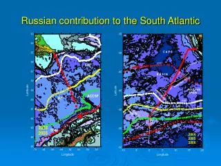
CPIES Transport Arrays:Drake Passage (17 CPIESs, blue) Chereskin, Donohue & WattsAfrica-Antarctica (23 CPIESs, red) 23 CPIESs Δx = 154 -159 km 17 CPIESs Δx = 30 – 75 km
ISSUES ● Should CPIES spacing (~155 km) be reduced in high-energy/frontal regions (e.g., Agulhas rings, SAF, PF) and correspondingly increased in other regions? ● Is 60˚S an appropriate southern terminus for the array? ● Alternatively, should we limit the CPIES array to the region north of Olaf Boebel’s ANT-5 site (~42˚S)? ● Can we better integrate the array with PIESs from others: Boebel, Speich, Byrne, Garzoli, etc? ● How many CPIES instruments do we need? Is 23 enough? ● What ships can we use to deploy and recover the CPIES instruments in the array? ● Will it be possible to take CTD casts at the CPIES sites? How often? ● Should we consider acoustically telemetering the data to a ship, prior to instrument recovery, e.g., once a year? ● Are multi-component GEM fields needed to interpret the data? ● Can we hope to use such an array to measure heat and salt fluxes in addition to mass fluxes?