Download
1 / 29
290 likes | 307 Views
Explore the historical development of geology and the theories that led to the understanding of plate tectonics. From fixism theories to Alfred Wegener's theory of continental drift, discover the evidence that supports the idea of a mobile Earth. Learn how the modern theory of plate tectonics explains the movement of continents and the formation of various geological features.

E N D
From the Continental Drift to the theory of PlateTectonics A global theory of the evolution of the Earth Chemistryteacher: Fonti Nunziata; English Teacher: Cocivera Maria Pia
Fixismtheories-These theories were in the last years of the XVIII century • In 1666, the Frenck monk F. Placet made the hypothesys that the American Continent originally bridged to Africa, through Atlantide later sinked. This would explain the presence of the same fossils in both America and Africa. This theory, however, cannot be accepted on the basis of isostasy, according to which the Continental areas are made of rocks that are lighter than the denser seabed rocks. • The Austrian geologist Suess made the theory of the Crust Contraction, according to which Hearth has progressively got cold, reducing its volume and wrinkling, yet, this theory is not convincing for two reasons: - firstly the cooling should have been of thousand of degrees; - secondly, the mountains should have had the same distribution on the whole Planet, which is not true. .
The French Theory G. Cuvier (1769-1832) • The French Biologist G. Cuvier formulated the “Catastrophe Theory”, according to which our Planet has always alternated violent catastrophic events to quiet long eras. This theory was partly successful because it matched the biblical creation, but it was not scientifically untrue.
The Actualism Theory by L.Lyell( 1797 – 1875) a Scottish Geologist • “The Actualism Theory” by L. Lyell, a Scottish geologist, observing the columns of “Serapide Temple” in Pozzuoli, he noticed in them the presence of holes made by the Dattel mussel in only 3 metre level. Thismeans that the columns had probably sunk into the sea, to emerge later, according the phenomenon of bradisisme.
The Actualism or Uniformism of Lyell • According this theory the strength that mould the world – the action of rain, of see, of volcano and of heart-quake – are the same that acted in the past, and gradually act and in a constant way in time.
First dubts arised • The Dutch cartographer Ortelius published in 1570 his collection of maps in the same graphic scale with the title of “theatrumOrbisTerrarum” , the first world Atlantis of 8 papers then published in 7 languages and 36 editions. • Ortelius drew up his maps by his professional friendly contacts with the European cartographers. • In 1569 they also published the Atlas of Mercatore, a flemish cartographer. • Observing the maps, it was noticed that getting African, European, South American and North American coasts near, they matched surprisingly. So, it was consequently maintained that the American continent had split up from Africa and Europe, initially because of earthquakes and floods and later, according to Wegener, after a drift.
In 1620, the philosopher Bacone, by the observation of those maps, noticed the similarity in the shape of oriental coast of South America with the western African one.
1912 - Drift of continentThe German meteorologist Alfred Wegener presented his theory pubblished in a full form in 1915.
His theory is based on different evidence:1. Paleonthologicevidence: he observes that on the complementary coast of both Africa and South America the same fossils of both animals (Mesosaurus) and plants (Glossopteris) were found.2. Paleoclimaticevidence : presence of fossils of tropical plants in polar regions (Siberia, North America,…), glacial deposits in South Africa, India, Australia has been traced.
3. Geographic evidence: complementarity of coast lines. 4. Geologic evidence: for 200 millions years, the same layers havebeen present. “ It’s as if – Wegener writes – we had to match teared apart pages of a newspaper. If it is possible, this means that the two Continental areas were originally unified”
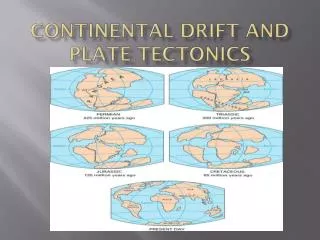
Wegener and theTheory of Continental Drift • According to this theory about 200 millions years ago all continents were a single mass, the Pangea supercontinent, surrounded by a single big ocean, the Pantalassa. • Since that time, the Pangea was divided into continents that have undergone a movement drift.
The weakness of the Wegener’s theory was the choice of the driving forces: • the socalled force of escape from the poles that explained the continental through moviments to wards the equator the friction along the edges of the corrugation a relief alpine-himalayan and the atlantic mountain rangeraised. • the inertial force of continents respect to the Earth’s rotation explains the drift to west of the American continent. The friction along the edge to west has caused a corrugation of western border, giving origin to Rocky Montains and to Andes. • These forces, however, scemed to be too weak.New intuitions were needed to affirme the idea of a “mobile Earth” new.
At the beginning of the fifties, scientists start their observation of the ocean floors, through the bathyscaph, and detect ridges and trenches through the magneto-meters (tools used during the second world war to intercept the submarines); they notice abnormal magnetic variations along the see-floor. On the floors, they observe: • the ridges that creat a system of submerged reliefs present in all oceans, for a total of 60.000 Km, their raising above the ocean floors of about 2-3.000 m and they emerge at the same levels of Island and Azores Islands • the trenches, which are oceanic depressions, can go deep 10.000 m.
From the studies on the Earth’s magnetism1 - the independent evidence: Magnetic anomalies on the oceanic floors • the oceanic floor presented alternated bands of rocks, where the magnetism had a normal and reverse polarity. • The presence of two types of anomalies demonstrates that the oceanic floor has slowly formed; in fact, the floors near the ridge are younger than those next to the continent, with a bigger quantity of sediments in proximity to the continents. The hypothesis of the expansion of the oceanic floors grants the interpretation of these observations.
2 – Paleomagnetism and apparent migration of the poles.In the igneous and sedimentary rocks, at the moment of the formation, the magnetic minerals follow the magnetic field present at the moment of their formation, becoming small permanent magnets. Around 1950, the English researchers observed that the magnetization of ancient rocks was different from the current magnetic field and also the direction that indicated the magnetic north pole changed with the age of rocks. It seemed that the Earth’s magnetic poles moved during the time. A deep study demostrated that the rocks of the same age located in different continents pointed at a different position of the magnetic pole. This caused a change of prospective.
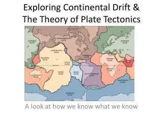
Theory of Plate Tectonics • At the begginning of the 60’s of the XX century, it was thought that the zone of intense activity in correspondance of the ridges – with formation of a new oceanic litosphere – and of the trenches – with destruction of ocean floor – were some now connected. • The American geologist of Princeton University, Harry Hammond Hess (1906-1969) proposed, on the bases of these information, the hypotesis of expansion of oceanic floor, till the global theory on the evolution of our planet: the Plate Tectonics. • The rigid lithosphere, made up of crust and upper mantle, is subdivided into about 20 plates, of which 6 greater plates, that move and interact along the margins; they are classified in: a. costructive or divergent margins – corresponding to the oceanic ridges; b. distructive or convergent margins – corresponding to oceanic trenches; c. conservative margins – corresponding to transform faults. • The lithospere, hard coating, floats and slides on the smoother astenosphere,thanks to the convective motions that originate from eruption on the ridges level, with ocean floor’s expansion, while the trenches level , the litosphere returns to the mantle and it recycled with the subduction.
In this slide we can see the plates in whichlithosphereisdividedinto
Constructive or divergent margin we associate: Structures • 1. Transform faults • 2. Mid-ocean ridge • 3. Tectonic tranches, introduce , in general, the scission of an unique continental area in two parts with an opening of a new ocean. Phenomena • 1.Earthquake with superficial hypocenter • 2.Basaltic volcanism
Buckle/ warp and rift valley that leads to: Breaking of a continental plat (Arabia separates from Africa) and opening of a future ocean (current Mar Rosso)
Distructive and convergent margin we associate: Structure • Ocean trench • Benjoff’s floor, inclined of about 45° compared to the surface, this is up to about 700 Km deep • Island arc: Japan, Marianne, Kurili… • Marginal mountain: Ande and Hymalaya Phenomena • Earthquake with hypocenter located along the Benjoff’s floor; • Volcanism explosive type, with andesitic lavas
Volcanic Insular Arc Cordillera Mountain ridge We can see a distructive edge with volcanic phenomena, subduction,… Slab in Subduzione • The heaviestplateissubducted: • ConvergenceOcean-Ocean: the oldest and the coldest • ConvergenceOcean-Continent: the oceanicone • ConvergenceContinent-Continent: • the oldest and/or the thinnest
- A distructive edge with formation of an island with volcanic features in parallel to the coast;- India and its drift
Conservative edgewe can associate:Structure: trasformfaultsPhenomena: Earthquakes with superficialhypocenter
Wilson cycle • Thecicleof the supercontinentsdescribes the dynamicsofsemi-periodicaggregations and driftsof the continentalcrustofEarth. Infact the allresearchersagree on the factthat the Earth’s crusthasundergone a constantreconfiguration. Between the creationof the supercontinent and the subsequentittakesabout 300/500 millionsyears.