Download
1 / 34
340 likes | 512 Views
Explore Canada's geography through the 5 themes: Location, Place, Human-Environment Interaction, Movement, and Regions. Learn about Canada's absolute and relative location, physical and human characteristics, resources, and environmental impact.

E N D
Canada and the 5 Themes of Geography:A Study Guide Our neighbor to the north
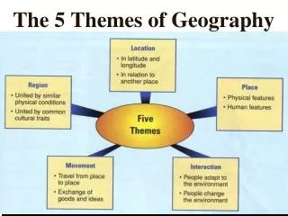
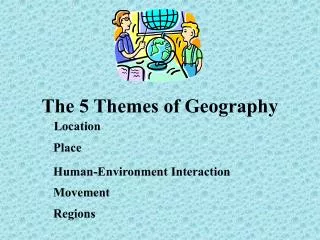
The 5 Themes of Geography • Location where places are • Place characteristics of places and the people who live there • Human/Environment Interaction relationships between people and their environments • Movement movement of material, people, or ideas among places • Regions areas sharing several characteristics
Location Geographers want to know • Where is it? • Absolute Location (the address) • Relative Location (where is it in relation to other places?) • Why is it located there?
Absolute Location and Canada • Does Canada have an ‘address’? Cities and towns in Canada do! Each place in Canada has an address. Geographers identify these addresses using: Latitude Longitude AND
Windsor, Ontario, Canada’s absolute location is: 42° 16' N Latitude 82° 58' W Longitude Using latitude and longitude, we can identify the absolute location of any place on the globe!
Relative Location and Canada Canada is west of ____________. Canada is east of ____________. Canada is south of ____________. Canada is north of ____________. These statements are examples of Canada’s relative location!
More examples ofrelative location • Canada is just a short drive from Detroit. • Vancouver, Canada is southeast of Alaska. • Canada is northeast of Hawaii. • Much of Canada is south of Alaska. • Canada is north of most areas of the United States, but not all! • Toronto is southwest of Maine. • Can you think of another example?
PLACE What is it like?
EXAMINING PLACE Physical (natural) Characteristics • What are Canada’s major landforms? • What are Canada’s major bodies of water? • What types of plants and animals can be found in Canada? • Describe Canada’s climate. • Describe Canada’s soil. • Does Canada have any minerals?
EXAMINING PLACE Human Characteristics • How large is Canada’s population? • What cultural characteristics are found in the people of Canada? • How does Canada use its land? • What roads could you find in Canada? • What buildings could you find in Canada? • What are Canada’s major economicactivities?
HUMAN-ENVIRONMENT INTERACTION How do people interact with and change their environments?
Human Use people depend on the environment and its resources What resources do Canadians use? Let’s try this… It’s a big country…
Using the Resources of Canada Provinces and Territories Examples of important resources How are these resources used? ATLANTIC (MARITIME) PROVINCES • Nova Scotia • Prince Edward Island • New Brunswick • Newfoundland and Labrador • fish • Atlantic Ocean • minerals • land fishing industry farming mining shipping tourism • St. Lawrence Seaway • Great Lakes (4 of 5) • minerals • Ontario • Quebec manufacturing shipping steel tourism PRAIRIE PROVINCES • Alberta • Manitoba • Saskatchewan • fossil fuels (coal, oil, and natural gas) • fertile soil • trees • cattle farming ranching mining oil production • British Columbia • trees • lakes • rivers forest industry lumber processing processing lumber shipping paper manufacturing hydroelectric power THE TERRITORIES • Yukon Territory • Nunavut • Northwest Territories • animals • fish • minerals mining
Human Adaptation people change in response to different environments How have Canadians adapted to their varied environments? It’s a big country… Let’s try this…
See if you can complete these sentences… • Most Canadians live within 100 miles of Canada’s southern border because __________________________________. • The shelters in northern Canada are different from the ones in southern Canada because _______________________________________________. • The reason farming is a major industry in the Prairie Provinces is _____________________________________. • The reason few farmers live in the Canadian Shield is _______________________________________________. • The St. Lawrence Lowlands region is the home of many major industries because _______________________________________________________________________________________________. Canada’s northern climate is too severe for most Canadians. Canadians build shelters based on the environment and climate. the Prairie Provinces have very fertile soil so farming is profitable. there is very little soil for farming in the Canadian Shield. The St. Lawrence Seaway provides a major shipping route making it profitable for many industries to locate there.
Human Impactpeople change the environment How have Canadians changed their environment? It’s a big country… Let’s try this…
Explain how each of the following has changed Canada’s environment. • The St. Lawrence Seaway • The Mining Industry • The Timber Industry • The Agriculture Industry The seaway added canals and locks to bypass the narrow and shallow parts of the St. Lawrence River. The land has been altered as minerals and fossil fuels have been removed from the ground. Forests have been cleared for timber. Roads have been built to transport the timber for processing. Land has been plowed and vegetation removed to make way for crops. Farming communities have used other lands previously empty.
MOVEMENT • Movement of Material • Movement of People and Other Living Things • Movement of Ideas and Information
Movement of Materials Transportation by nature Transportation by people
MIGRATIONmovement of PEOPLE and other LIVING THINGS • Movement of People • Movement of Other Living Things
DIFFUSIONmovement of IDEAS and INFORMATION • Movement of Ideas • Movement of Information
Which type(s) of movement?Can you tell the difference? Be prepared to explain your answers. (Note: There could be more than one correct answer!)
REGIONS • How can we generalize about areas of the world? • Which places share similar characteristics or processes?
Types of Regions • Natural or Physical Regions • Places (areas) that share a physical characteristic or process (landforms, climate, other physical characteristics) • Human Regions • Places (areas) that share economic, political, or human characteristics • Composite Regions • Places (areas) that share several characteristics (culture regions and ecosystems)
IMPORTANT!!!!! A place might belong to many different regions at the same time. • Example- Windsor, Ontario • Windsor is in the political region of the province of Ontario. • Windsor is in the economic region of Quebec/Ontario. • Windsor is in the physical region of the St. Lawrence Lowlands.
Canada’s Physical Regions • Canadian Shield • St. Lawrence Lowlands • Appalachian • Interior Plains • Western Mountains • Hudson Bay Lowlands • Arctic Islands
Canada’s Human Regions: Economic • Atlantic (Maritime) Provinces • Ontario and Quebec • Prairie Provinces • British Columbia • The Territories
The Atlantic (Maritime) Provinces • The region’s provinces have at least one border on the Atlantic Ocean or one of its gulfs and seas. • The fishing industry employs approximately 3% of the region’s workers. • Most jobs in the region are in manufacturing, farming, mining, shipping, and tourism.
Quebec and Ontario • Region considered the ‘heartland of Canada’ • An economic region that contains two separate cultural (Composite) regions • Ontario • English Canadian • Quebec • French-Canadian • Region holds most of Canada’s population and two largest cities • Montreal, Quebec and Toronto, Ontario • Region produces most of Canada’s manufactured goods • Region produces a range of consumer goods and products from other industries, including iron and steel • Region located near major waterways • St. Lawrence Seaway provides direct access to the Great Lakes and the Atlantic Ocean • Region’s major centers of economic activity • Quebec: Montreal • Ontario: The Golden Horseshoe (including Toronto)
The Prairie Provinces • Largest cities in the region: • Edmonton and Calgary in Alberta • Winnipeg in Manitoba • Fertile soil – great farming • Known as Canada’s ‘breadbasket’. Southern portion of the region has many wheat farms and ranches. • Northern portion of the region covered by forests. • Region supplies most of Canada’s fossil fuels including • Coal • Oil • Natural gas
British Columbia • Region includes a single province • Largest city is Vancouver • Contains Canada’s busiest port • Links Canada to trading partners in Asia and the United States • Contains evergreen forests and many rivers and lakes • Economic activities: • Cutting trees • Processing lumber • Manufacturing paper • Fishing • Recreation • Hydroelectric power
The Territories • Region covers a huge area of northern Canada (40% of Canada’s total land area!) • Very few people • No large cities • Most people meet their basic needs by • Hunting • Fishing • Little major economic activity other than • Mining
The 5 Themes of Geography…remember? • Location • Place • Human/Environment Interaction • Movement • Regions