Download
1 / 29
290 likes | 445 Views
Hastings, Nebraska National Weather Service Considerations for TAF Composition. UNK Aviation Department October 12, 2006. NWS Hastings TAF Site. Grand Island (KGRI) Located 2 miles east-northeast of Grand Island Elevation: 1846 ft. MSL. NWS Hastings TAF Site. Grand Island (KGRI)

E N D
Hastings, Nebraska National Weather Service Considerations for TAF Composition UNK Aviation Department October 12, 2006
NWS Hastings TAF Site • Grand Island (KGRI) • Located 2 miles east-northeast of Grand Island • Elevation: 1846 ft. MSL
NWS Hastings TAF Site • Grand Island (KGRI) • Airport is serviced by an ASOS • Augmentation of observations is performed by Grand Island Control Tower personnel from 0600 to 2200 local time • Occurrences of precipitation or thunderstorms are manually appended to observations as a remark
NWS Hastings TAF Site • Grand Island (KGRI) • Main forecast considerations • Diurnal pressure gradient winds • Thunderstorm intensities during convective season • Low ceilings/visibilities during stratiform precipitation events • Radiation Fog
NWS HastingsTAF Preparation • Current surface weather observations • At the very least…get the first period right! • Forecaster can declare a “NIL” TAF after 2 hours of missed observations at a site • Satellite imagery • View previous 12 hours to gain understanding of weather history and evolution • Helpful in “persistent” or “progressive” patterns
NWS HastingsTAF Preparation • Graphical weather model data • Numerical guidance • Meteograms • Tabular • Seasonal climatology • Knowledge of local effects • Pilot reports (if available)
NWS HastingsTAF PreparationSpecial Considerations • Low ceilings/visibilities • Most prevalent during the winter • Typically associated with large (multi-state) low pressure systems
NWS HastingsTAF PreparationSpecial Considerations • Low ceilings/visibilities • Best forecast tools to use: • Fog channel of satellite imagery • Differentiates better between the ground and low clouds/fog • NWS has many enhancement curves that are not always available to the general public. • Airport observations critical since pireps in these situations usually decrease dramatically
NWS HastingsTAF PreparationSpecial Considerations • Radiation fog • Best forecast tools to use: • Fog channel of satellite imagery • Differentiates better between the temperature of the ground and low clouds/fog • NWS has many enhancement curves that are not always available to the general public. • Temperature and dew point spread information from observations • Tabular model guidance
NWS HastingsTAF PreparationSpecial Considerations • Non convective low level wind shear (LLWS) • LLWS may be associated with: • Frontal passages • Inversions • Low level jets
NWS HastingsTAF PreparationSpecial Considerations • Non convective low level wind shear (LLWS) • Should be included in TAF when: • Vertical shears of 10 kts or more per 100 feet in a layer more than 200 feet are expected, or observed within 2000 feet of the ground • Pireps received which indicate wind shear causing a gain or loss in airspeed of 20 kts or more within 2000 feet of the ground.
NWS HastingsTAF PreparationSpecial Considerations • Non convective low level wind shear (LLWS) • Best forecast tools to use • KMAX WSR-88D vad wind profiler • Upper air sounding • Pilot reports
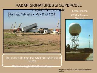
NWS HastingsTAF PreparationSpecial Considerations • Thunderstorms • Thunderstorms that occur over the Central Plains can be of the most severe nature • Thunderstorms elements include: • Extended periods of heavy rainfall • Large to enormous hail • Strong straightline winds • Occasional tornadoes
NWS HastingsTAF PreparationSpecial Considerations • Thunderstorms • Best forecast tools to use: • Visible and infrared satellite imagery • Track developing storms • Storms typically begin along an identifiable boundary • KUEX 88D Hastings Doppler Radar • Correlate locations of storm centroids with what is seen in satellite imagery
NWS HastingsTAF PreparationSpecial Considerations • Thunderstorms • Best forecast tools to use: • Upper air sounding • Helps to determine general instability of atmosphere • Identify wind speed and direction which frequently acts as main steering flow for storms • Model data
NWS HastingsTAF PreparationSpecial Considerations • Any other forecasting considerations that you would like to discuss?