Download
1 / 3
30 likes | 163 Views
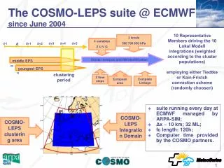
The COSMO-LEPS suite @ ECMWF since June 2004. 10 Representative Members driving the 10 Lokal Modell integrations (weighted according to the cluster populations) employing either Tiedtke or Kain-Fristch convection scheme (randomly choosen). 3 levels 500 700 850 hPa. 4 variables Z U V Q. d+3.

E N D
The COSMO-LEPS suite @ ECMWF since June 2004 10 Representative Members driving the 10 Lokal Modell integrations (weighted according to the cluster populations) employing either Tiedtke or Kain-Fristch convection scheme (randomly choosen) 3 levels 500 700 850 hPa 4 variables Z U V Q d+3 d+4 d d+5 d+1 d+2 d-1 Cluster Analysis and RM identification Cluster Analysis and RM identification middle EPS 00 youngest EPS 2 time steps 12 European area clustering period Complete Linkage • suite running every day at ECMWF managed by ARPA-SIM; • Δx ~ 10 km; 32 ML; • fc length: 120h; • Computer time provided by the COSMO partners. COSMO-LEPS Integration Domain COSMO-LEPS clustering area
Current activities & future plans • COSMO-LEPS suite as “time-critical” application at ECMWF • MARS archiving of COSMO-LEPS products • 3-hourly boundary conditions • Participation to EURORISK-PREVIEW project: • integration domain will be enlarged to include Northern Europe; • clustering on different areas will be tested. • Participation to MAP D-PHASE project: • further downscaling (around 2 km hor. res.) on specific areas where severe events are likely to occur • Coupling with hydrologic models • Focus on verification.