Download
1 / 40
410 likes | 662 Views
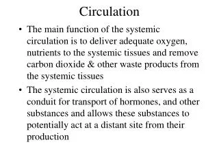
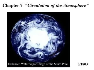
Chapter 7 “Circulation of the Atmosphere”. Enhanced Water Vapor Image of the South Pole. 3/1803. Chapter 6 “Air Pressure and Winds”. Understanding Air Pressure Measuring Air Pressure Factors Affecting Air Pressure/Wind Geostrophic Flow Curved Flow and the Gradient Wind Surface Winds.

E N D
Chapter 7 “Circulation of the Atmosphere” Enhanced Water Vapor Image of the South Pole 3/1803
Chapter 6“Air Pressure and Winds” • Understanding Air Pressure • Measuring Air Pressure • Factors Affecting Air Pressure/Wind • Geostrophic Flow • Curved Flow and the Gradient Wind • Surface Winds
Chapter 7 “Circulation of the Atmosphere” • Scales of Atmospheric Motion • Local Winds • Global Circulation • Observed Distribution of Pressure and Winds • Monsoons • The Westerlies
Scales of Motion in the Atmosphere Although we separate atmospheric motions according to size, the large scale global motions are comprised of all the smaller scales of motions.
Large winds patterns like the jet stream are also Macroscale winds
Thunderstorms are good examples of Mesoscale winds Strong vertical winds present with thunderstorms. There movement is determined in part by Macroscale winds.
A Seabreeze is also considered Mesoscale Wind cimss.ssec.wisc.edu/wxwise/
Microscale winds are the smallest scale of air motion May last for just a few seconds, chaotic in nature.
Local Winds (These are mesoscale winds) • Land and Sea Breezes • Mountain and Valley Breezes • Chinook (Foehn) Winds • Katabatic (Fall) Winds • Country Breezes
Land and Sea Breezes Temperature contrasts (the result of the differential heating properties of land and water) are responsible for the formation of land and sea breezes.
Mountain and Valley Breezes Similar to the land and sea breeze in its diurnal cycle are the valley and mountain breezes. Valley breezes occur in the day because air along mountain slopes is heated more intensely than air at the same elevation over a valley floor. Rapid radiational heat loss in the evening reverses the process to produce a mountain breeze.
Local winds can act together to create very strong winds Table Mountain in Cape Town, South Africa is an example of strong daily wind patterns because of the combination of afternoon mountain and sea breeze.
Chinook (Foehn) Winds These winds are often caused by pressure systems on the leeward side of mountains which pull air over the mountains. As the air descends the leeward slopes of the mountain it is heated adiabatically. Warm, dry winds sometimes move down the slopes of the Rockies, where they are called Chinooks, and the Alps they are called foehns. These naturally occurring winds can be very harmful to human activities.
Katabatic (Fall)Winds Cold air over highland areas is set in motion, gravity causes the air to rush over the edge of the highland like a waterfall. Katabatic winds are generally much stronger than a mountain breeze. There must be a strong temperature gradient with the colder air aloft. Diagram of Katabatic Winds Some Katabatic Winds • mistral • bora • Antarctica is the • windiest place on earth. Wind speeds of 300 kilometres
Single-Cell Circulation Model George Hadley, in 1735, proposed that temperature contrast between the poles and the equator creates a large convection cell in each hemisphere. Global circulation on a nonrotating Earth. A simple convection system is produced by unequal heating of the atmosphere on a nonrotating Earth.
Three-Cell Circulation Model The zones between the equator and about 30 ° north and 30 ° south very much resemble the Hadley cell. Intense heating (high solar angle most of the year) results in upward motion. As the flow moves northward it begins to cool and subside. Recall the Coriolis force increases with increasing latitude. Thus, the area between ~20-35 ° is characterized by subsidence.
Three-Cell Circulation Model In the 1920’s a three-cell circulation model (for each hemisphere) was proposed. Features of the circulation pattern: • horse latitude • trade winds • doldrums • prevailing westerlies • polar easterlies • polar front
Observed Distribution of Pressure and Winds • An imaginary uniform Earth with idealized zonal (continuous) pressure belts
Idealized pressure Belts Equatorial Low- warm air rising creates cell of low pressure. Intertropical Convergence Zone (ITCZ)- referred to as the convergence zone because this region is where the trade winds converge. Ascending air leads to cloud formation which makes this region clearly visible on satellite imagery. Subtropical Highs- These zones are caused primarily by Coriolis deflection which restricts upper-level winds from moving poleward. Subsiding air and divergent winds at the surface cause warm, cloud- free weather (many large desert areas are located along this latitudinal belt). Subtropical Highs tend to persist throughout the year, with the center of the high migrating, and are regarded as semi-permanent pressure systems.
Idealized pressure Belts (cont.) Subpolar Low – located around 50 to 60 latitude. Associated with the polar front. The belt of low pressure is formed by the interaction (convergence) of the polar easterlies and the westerlies Polar Highs – located over the poles! The process which produces the polar highs is different than the process which produces the subtropical highs. Surface cooling is the principle reason the polar high.
Semipermanent Pressure Systems: Land Sea interactions and Topography complicate the circulation patterns. We have viewed these pressure belts as continuous systems around the earth up to this point. However, because the Earth is not uniform at most latitudes (more so in the northern hemisphere), the zonal belts are replaced by semipermanent cells of high and low pressure.
Semipermanent Pressure Systems The real Earth with disruptions of the zonal pattern caused by large landmasses. These disruptions break up pressure zones into semi-permanent high and low pressure cells.
Average Surface Pressure Systems and Associated Circulation January Siberian High, Azores High Aleutian Low, Icelandic Low
Average Surface Pressure Systems and Associated Circulation July Bermuda High
Monsoons The seasonal reversal of wind direction associated with large continents, especially Asia. In the winter, the wind blows from the land to the sea; in the summer, it blows from the sea to the land. The Asian Monsoon The Asian Monsoon is the result of a complex interaction between the Siberian High (which is strongest in the wintertime), the migration of the ITCZ, and the topography of the region (i.e. the Himalayan mountain range and the Tibetan Plateau).
The Asian monsoon circulation occurs in conjunction with the seasonal shift of the ITCZ and development of the Siberian High. (dry, cool, continental air)
In the summer ITCZ migrates north and the Siberian High weakens which allows results in a reversal in wind direction. (moist, warm, maritime air)
Monsoons The North American Monsoon Extreme summertime heating over the desert Southwest, creates a low pressure system centered over Arizona that draws in warm, moist air from the Gulf of California.