Tectonics & Sedimentation
Tectonics & Sedimentation. Sedimentary basins. Sedimentary basins are the subsiding areas where sediments accumulate to form stratigraphic successions The tectonic setting is the premier criterion to distinguish different types of sedimentary basins

Tectonics & Sedimentation
E N D
Presentation Transcript
Sedimentary basins • Sedimentary basins are the subsiding areas where sediments accumulate to form stratigraphic successions • The tectonic setting is the premier criterion to distinguish different types of sedimentary basins • Extensional basins occur within or between plates and are associated with increased heat flow due to hot mantle plumes • Collisional basins occur where plates collide, either characterized by subduction of an oceanic plate or continental collision • Transtensional basins occur where plates move in a strike-slip fashion relative to each other EaES 350-13
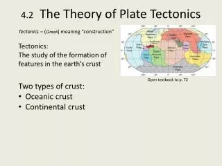
I) Tectonics and Sedimentation • A. Can explain sedimentary sequence with plate tectonic models • B. Cratonic sedimentation • 1. craton = stable continental interior, positive relief • 2. thin sedimentary sequences, unconformities • 3. positive relief leads to erosion & unconformities • 4. sedimentary sequence = ~ 1 km of Paleozoic and Mesozoic rks • i. l.s, s.s., sh = shallow marine, fluvial-deltaic • 5. local development of basins & arches • i. origin of basins = failed rifts?= Michigan basin Wiley.com Alberta Geol Society
II) Geosynclines • A. Trough that parallels continental margin = geosyncline • 1. subdivided in miogeosyncline & eugeosyncline • 2. miogeosyncline • i. = shallow marine ls & ss adjacent to craton • ii passes to deep water lithologies • 3. eugeosyncline • i. deep marine sediments, submarine volcanics, volcaniclastic sediments • ii. tectonically deformed • 4. no explanation of how geosynclines formed Steven Dutch
Sedimentary basins Extension • Rift basins develop in continental crust and constitute the incipient extensional basin type; if the process continues it will ultimately lead to the development of an ocean basin flanked by passive margins, alternatively an intracratonic basin will form • Rift basins consist of a graben or half-graben separated from surrounding horsts by normal faults; they can be filled with both continental and marine deposits • Intracratonic basins develop when rifting ceases, which leads to lithospheric cooling due to reduced heat flow; they are commonly large but not very deep EaES 350-13
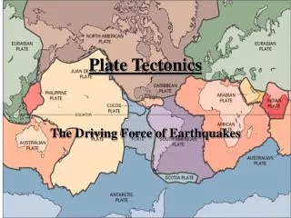
III) Plate Tectonics & Sedimentation • A. Explains geosynclines (now obsolete) • 1. miogeosyncline = shelf; eugeosyncline = slope & rise • B. Divergent margins • 1. 2 plates separating • 2. uplift = mantle plume • 3. extension = rift valley development • 1. normal faulting & down dropping • ii. eventually forms ocean basin • 4. coarse immature sediments deposited; alluvial, fluvial, lacustrine • 5. aulacogens may develop & fill • i. fluvial & deltaic deposits fill basin • 6. junction coalesce to form ocean basin • i. evaporites, marine sediments • 7. seafloor spreading develops & pelagic oozes
Rio Grande Rift--Active Nicolle Rager, NSF Properties of crust and upper mantle beneath the Rio Grande. Pure shear model is probable explanation, with a "taffy-like" thinning of the lower crust and the upper crust faulting in many places to produce the rift valley. This contrasts to "simple shear" model wherein a single, large detachment fault controls continental rifting.
Red Sea-Ocean Beginning • Deep axial trough, broad shallow shelf • Miocene (5-25mya) evaporites (over 4km thick) below shelf • Evaporties probably overlie thin, stretched continental crust • Evaporite deposition end 5 mya- connection to Indian sea established • Open ocean water led to flourishing plankton • Biogenic seds give way laterally to thin terrigenous clays, sands, gravels from eroding flanks Stephen A. Nelson
III) Plate Tectonics & Sedimentation • C. Convergent margins • 1. cont-cont collision = uplift & coarse clastic debris, fluvial deposits • 2. oceanic-oceanic collision = island arc • i. submarine volcanism & turbidites, shales, pelagic oozes • 3. ocean-continent collision = continental margin arc • i. felsic batholiths, silicic volcanics • ii. immature seds = alluvial & fluvial ss • ii. accretionary wedge, melange
Sedimentary basins Collision • Forearc basins form between the accretionary prism and the volcanic arc and subside entirely due to sediment loading; like trench basins, their fill depends strongly on whether they are intra-oceanic or proximal to a continent • Backarc basins are extensional basins that may form on the overriding plate, behind the volcanic arc • Retroarc foreland basins form as a result of lithospheric loading behind a mountainous arc under a compressional regime; they are commonly filled with continental deposits EaES 350-13
III) Plate Tectonics & Sedimentation • D. Transform Margin • 1. strike slip motion • 2. irregularities produce local extension & compression • 3. typical of southern California • i. may develop sediment-starved basin • ii. eventually infilled
Sedimentary basins Transtension • Strike-slip basins form in transtensional regimes and are usually relatively small but also deep; they are commonly filled with coarse facies (e.g., alluvial fans) adjacent to lacustrine or marine deposits EaES 350-13