
Navigational Update: Upcoming Waypoints and Speed Adjustments for Safe Passage
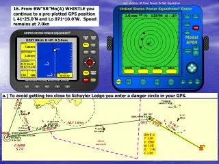
This navigational update prepares you for the next leg of your journey with essential details regarding waypoints, speed, and position. Your current location is N41°26.46’, W071°13.50’, with a direct course towards waypoint BB16, positioned 7.00 nautical miles ahead. Maintain a speed of 7.0 knots and remain vigilant of nearby navigational hazards, including the proximity to Schuyler Ledge. Ensure to monitor the distance to next waypoint, which stands at 0.00 nautical miles. Safe travels and remember to check all equipment and systems.

Navigational Update: Upcoming Waypoints and Speed Adjustments for Safe Passage
E N D
Presentation Transcript
½ 3.0 nm 135oM H - UP RR DNLT DNMT XTE DEST BWSR: H-UP: R 5.0nm SPEED 7.00nm ELGRG 71 10 DIST TO NEXT 0.00nm POSITION N 41o26.46’ SLR2 W 071o13.50’ VRM1 EBL1 VRM2 EBL2 0 100 TIME TO DIST 00:00:00 BWSR TYPE TYPE TYPE TYPE NAME NAME NAME NAME NAV LOCATION LOCATION LOCATION LOCATION TOWER C 215M S 5.0 WAYPOINT: SLR2 WAYPOINT: BB16 WAYPOINT: SLR2 WAYPOINT: SLR2 (ABAND LT HO) CUP DEST BB16: H-UP: R 5.0nm BB16 SLR2 SLR2 SLR2 West I Save Map Save Save Map Map Save Map Delete Delete Delete Delete SPEED 41 25 DEST BB16: H-UP: R 5.0nm R “4” GONG 7.00nm COMMENTS COMMENTS COMMENTS COMMENTS R “2” BELL NLT 1.0nm SPEED M0(A) WHISTLE 45 25 BB16 7.00nm DIST TO NEXT W071o11.491’ W071o11.601’ W071o10.000’ W071o11.601’ N41o26.409’ N41o26.409’ N41o26.409’ N41o25.000’ 0915 3.00nm NLT 1.0nm BB16 Fl 6sec 64ft 15M HORN DIST TO NEXT 71 10 BW “A” R “2A” BELL DISTANCE DISTANCE DISTANCE DISTANCE R “2” Fl R 4sec WHISTLE BEARING BEARING BEARING BEARING 3.00nm NLT 272M POSITION Fl 3sec 01.48nm 03.00nm 01.48nm 01.48nm N 41o26.46’ 108.8M 108.8M 134.7M 108.8M 71 10 SLR2 0812 Priv maintd W 071o13.52’ BRENTON REEF Gp Fl (2) 10sec 87ft 15M HORN PA R Bn 292 POSITION N 41o26.46’ FIND SLR2 W 071o13.50’ 130 140 TIME TO DIST AREA 2 (see note B) 00:25:42 BWSR C 098M S 7.0 130 140 TIME TO DIST 00:25:42 BWSR ! ! ! ! ! ! ! ! ! ! Art Mollica, St Paul Power & Sail Squadron 16. From BW”SR”Mo(A) WHISTLE you continue to a pre-plotted GPS position L 41o25.0’N and Lo 071o10.0’W. Speed remains at 7.0kn DNLT 0.7nm a.) To avoid getting too close to Schuyler Ledge you enter a danger circle in your GPS. BW“SR” C 135M S 7.0 D NLT 0.7nm 0915 C T 120 V 15W M 135 D 1W C 136 BB16