Download
1 / 1
10 likes | 119 Views
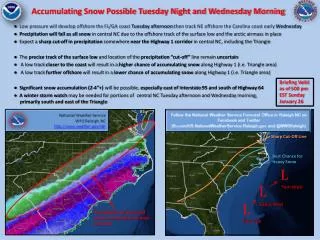
Stay informed about the approaching winter storm with the potential for significant snow accumulation in central North Carolina. Low pressure developing offshore the FL/GA coast will track NE near the Carolina coast, leading to all snow precipitation in central NC due to the Arctic airmass. Expect a sharp precipitation cut-off near Highway 1 corridor with uncertainty on the low track and cut-off line. Higher snow chances along Highway 1 with potential for 2-4"+ accumulation. Winter storm watch may be issued for south and east of the Triangle area. Snow amounts and accumulation are most uncertain. Stay updated for possible heavy snow by early Wednesday morning.

E N D
Accumulating Snow Possible Tuesday Night and Wednesday Morning Briefing Valid as of 500 pm EST Sunday January 26 Sharp Cut-Off Line ● Low pressure will develop offshore the FL/GA coast Tuesday afternoon then track NE offshore the Carolina coast early Wednesday ● Precipitation will fall as all snow in central NC due to the offshore track of the surface low and the arctic airmass in place ● Expect a sharp cut-off in precipitation somewhere near the Highway 1 corridor in central NC, including the Triangle ● The precise track of the surface low and location of the precipitation “cut-off” line remain uncertain ● A low track closer to the coast will result in a higher chance of accumulating snow along Highway 1 (i.e. Triangle area) ● A low track further offshore will result in a lower chance of accumulating snow along Highway 1 (i.e. Triangle area) ● Significant snow accumulation (2-4”+) will be possible, especially east of Interstate 95 and south of Highway 64 ● A winter storm watch may be needed for portions of central NC Tuesday afternoon and Wednesday morning, primarily south and east of the Triangle Best Chance for Heavy Snow L L 7am Wed 12am Wed L Precipitation amounts and snow accumulation are most uncertain 7pm Tue