Download

1 / 17
180 likes | 402 Views
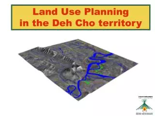
Land Use Planning in the Deh Cho territory. Overview. Who are the Land Use Planning Committee? What is Land Use Planning? How does this relate to the Deh Cho Process? What have we accomplished? What are the next steps? How and when do communities get involved?. Who Are We?.

E N D
Overview • Who are the Land Use Planning Committee? • What is Land Use Planning? • How does this relate to the Deh Cho Process? • What have we accomplished? • What are the next steps? • How and when do communities get involved?
Who Are We? • 5 Committee members • 2 DCFN reps (Tim Lennie and Petr Cizek) • 1 GNWT rep (Bea Lepine) • 1 Federal Government rep (Adrian Boyd) • Chairman selected by the other 4 members (Herb Norwegian) • 5 Staff members • Acting Executive Director (Heidi Wiebe) • Office Manager (Sophie Bonnetrouge) • GIS Analyst (Chris Turner) • Land Use Planner Trainee (Priscilla Canadien) • Recruiting final staff member
What is Land Use Planning? ? ? ? ? No development Development with conditions Development Timber Tourism Mining Oil and Gas Potential Land Uses Land Use Policies Decisions Zoning
Land Use Planning Process Map traditional land use and occupancy for hunting, fishing, trapping, gathering, and cultural sites. Identify sensitive harvesting and cultural areas. Biologist identifies sensitive wildlife areas. Forester identifies areas of high timber potential. Geologist identifies areas of high oil and gas potential. Geologist identifies areas of high mineral potential. Overlay maps, make decisions and prepare land use plan.
Social, Economic and Demographic Factors Forecast population growth over 20 years and identify job creation needs and skill levels. Identify maximum job creation potential in each natural resource sector. Tourism Mining Timber Balance job creation goals between sectors to meet needs, skill levels, and economic diversification Oil and Gas Integrate with land use zoning decisions to ensure enough land is available to support each sector. Commercial Wildlife Harvesting
Special Management or Buffer Zones • Functional Restrictions • Seasonal • Pollution Discharge • Specific Activities (roads, clear-cutting) • Spatial Restrictions (Proximity) • Strict conditions on development near water, wildlife habitat and cultural sites • Spatial Restrictions (Density) • Establish upper limits or thresholds on amount of development per area
Land Use Zoning Concept Map Core Protected Area – No Development Core Development Zone Buffer Zone – Restricted Development
Land Use Planning and the Deh Cho Process • Interim Land Withdrawals and land use planning use the same process • Land Withdrawals are a rough estimate based on broad information • Land Use Planning is a longer process, with time to collect more information and make more informed decisions • Withdrawals are for 5 years to give us time to develop a plan and get it approved
Our Process Established by the Interim Measures Agreement: • Phase 1 – Committee establishment and office setup • Phase 2 – Information gathering and analysis • Phase 3 – Plan preparation • Phase 4 – Plan implementation
Accomplishments • Committee establishment • Office setup (Fort Providence) • Staff recruitment • Initiate research through contracts • Develop communications materials • Compile research into Deh Cho Atlas and summaries • Build awareness of Committee activities
Next Steps • July - First Round of Community Visits (Information sharing) • Summer - Data Integration and Analysis • Summer – Fall - Develop Economic Assessment model • Fall – Wildlife Working Group • Fall - Develop preliminary land use options • Fall - Evaluate and revise options based on results of economic assessment model • Late Fall – Second round of community visits to present draft land use options
Community Involvement Why get involved? • The Land Use Plan is a major step towards people in the Deh Cho having control over development and making decisions for themselves about how their land will be used. • The Land Use Plan will be legally binding and will guide future decision making around resource development, protected areas and other land uses.
Community Involvement How and when can you get involved? • Community visits and consultation • Wildlife working group and other workshops • Visit our office in Fort Providence anytime (or phone, fax, email) • Contact your DCFN representatives (Petr and Tim)
Mahsi Cho! • Come and see us at our tent to review the research we’ve collected • Posters, pens, brochures, website, presentation, Deh Cho Atlas V. 2, research summaries • Staff and Board members available to answer further questions • Snacks and refreshments!