Download
1 / 16
170 likes | 483 Views
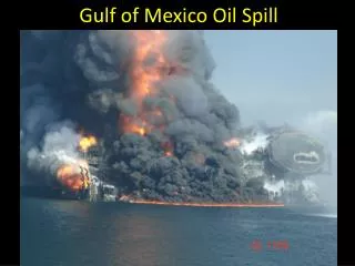
Mobile Crowdsourcing in the Gulf of Mexico Oil Spill Considerations for Integration with Professional GIS. Robert Laudati Trimble Navigation Ltd. November 16, 2010. Introduction. The Gulf of Mexico Oil Spill was one of the worst environmental disasters in recent times

E N D
Mobile Crowdsourcing in the Gulf of Mexico Oil SpillConsiderations for Integration with Professional GIS Robert Laudati Trimble Navigation Ltd. November 16, 2010
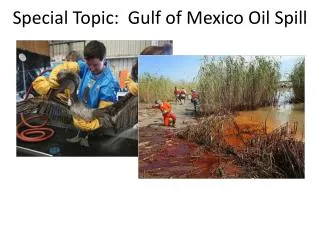
Introduction • The Gulf of Mexico Oil Spill was one of the worst environmental disasters in recent times • Collecting geospatial data in the field to record the extent and severity of the Spill involved a wide range of traditional and untraditional methods • Included a diverse set of field workers ranging from GIS experts to those who had never used a computer
Crowdsourcing During the Spill • Smartphones were easy to use without much training • Volunteers and citizens used crowdsourcing to record incidents, capture images and video, and blog on conditions in real time • A key use of crowdsourced data was to prioritize sparse cleanup resources
Was It Really Crowdsourcing? • Various terms have attempted to describe geospatial data created and shared by the public • Crowdsourcing • Volunteered geographic information (VGI) • Citizen science • A new term needed for directed, sometimes paid crowdsourcing , e.g.“Prosourcing”
Was the Data Good Enough? • Generally crowdsourced data is not perceived as high quality information compared with “professional” GIS • A few studies point to equal or better quality of crowdsourced data versus commercial data • Some reports indicate that crowdsourced data in the Gulf was deceptive* • No way to distinguish if posts were created by a professional or by a citizen • Labeling of reports as "verified" could be misleading *Pew Research
Oil Spill Crisis Map • Organized by the Louisiana Bucket Brigade and Tulane University students • Built using free, open-source software from Ushahidi • Submit reportsfrom: • Cell phone • Web form • SMS or MMS • E-mail • Twitter
Oil Reporter • Initiative by the Crisis Commons • Android and iPhone applications • Key capabilities • Incident reports • Geotagged photos • Information on volunteering to help with the spill response • Contacts for relevant government agencies • Oil Reporter Map (Android app)
Oil Spill Response • Free iPhone app by NVision Solutions • Reports on oil incidents as well as generic reports on oil related damage and oil related incidents • Users can upload images along with their reports • Reports are available for viewing in an online map as well as the iPhone
Trimble Map the Spill • Mobile app and website free to the public • Developed by Trimble Outdoors in three weeks • Create reports, mark oil damage locations, add comments, submit photos & video • All reports, news, and social media on mapthespill.org • Data can be freely shared
Map the Spill Overview DA TA FEE D S • Experts and citizens subscribe and download MaptheSpill app from the web site to view: • Interactive map • Reports • Photos • Social media • Blog updates • Downloads • ArcGIS data feed Data managed on Trimble hosted site MaptheSpill.org. MaptheSpill subscribers can view data on TTC public portal, or data feeds can be built to populate other systems using filters to provide relevant information • Application support for > 30 smartphone platforms. Provide capabilities to: • Log a report with location, comments, pictures, video • Retrieve reports and view latest reports from other subscribers • Get latest news from the web via RSS • Integrate with Facebook and Twitter feeds • Messaging between MaptheSpill subscribers
Fusing Crowdsourced Data • One of the limitations of many of the crowdsourced attempts in the Gulf was the lack of integration with decision support systems beyond the community of mobile app subscribers • The fusion of data sources requiresknowledge aboutorigin and quality, not typically capturedin a mobile app
Lessons Learned in the Gulf Spill • The wide range of users demanded a crowdsourcing methodology to meet the requirements of the crisis • By leveraging the crowd, volunteered reports and data were used effectively to optimize scarce resources to focus on the most significant problems • Further evolution of crowdsourced technology and integration with professional GIS can facilitate emergency response and routinedata collection efforts in the future
Summary • In emergency response situations, there will be a wide variety of user experience and knowledge that need to be managed • The requirements for open and real-time spatial data in these situations can be accelerated by involving the crowd • Data fusion is critical to successfully integrating information from a wide variety of sources • The success of “prosourcing” in crisis mapping may require a metadata standard to determineauthenticity and accuracy for decision making