1 / 2

Geodetic Observations and Documentation at UCA1 Vertex, Deception Island

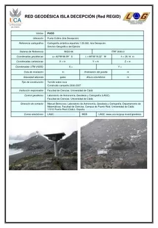
This report presents comprehensive geodetic observations and photographic documentation related to the UCA1 vertex within the .RED.GEODÉSICA network on Deception Island. It includes data collected through the REGID network, aimed at assessing the geological and geospatial characteristics of the area. The findings contribute to a better understanding of the geodynamics and physical geography of Deception Island, enhancing our knowledge of this unique volcanic landscape.

ayasha
Download Presentation

Geodetic Observations and Documentation at UCA1 Vertex, Deception Island

An Image/Link below is provided (as is) to download presentation Download Policy: Content on the Website is provided to you AS IS for your information and personal use and may not be sold / licensed / shared on other websites without getting consent from its author. Content is provided to you AS IS for your information and personal use only. Download presentation by click this link. While downloading, if for some reason you are not able to download a presentation, the publisher may have deleted the file from their server. During download, if you can't get a presentation, the file might be deleted by the publisher.

E N D

Presentation Transcript


  1. RED GEODÉSICA ISLA DECEPCIÓN (Red REGID)

  2. Vértice UCA1 (Red REGID) OBSERVACIONES DOCUMENTACIÓN FOTOGRÁFICA

More Related