Download
1 / 28
280 likes | 446 Views
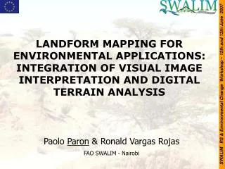
LANDFORM MAPPING FOR ENVIRONMENTAL APPLICATIONS: INTEGRATION OF VISUAL IMAGE INTERPRETATION AND DIGITAL TERRAIN ANALYSIS. SWALIM RS & Environmental Change Workshop – 12th and 13th June 2007. Paolo Paron & Ronald Vargas Rojas FAO SWALIM - Nairobi. WHAT are Landforms?

E N D
LANDFORM MAPPING FOR ENVIRONMENTAL APPLICATIONS: INTEGRATION OF VISUAL IMAGE INTERPRETATION AND DIGITAL TERRAIN ANALYSIS SWALIM RS & Environmental Change Workshop – 12th and 13th June 2007 Paolo Paron & Ronald Vargas Rojas FAO SWALIM - Nairobi
WHAT are Landforms? WHY mapping Landforms? HOW to map Landforms? Previous Landform Mapping in Somalia SWALIM Landform Mapping Approach Results Further Uses of Landform Maps Conclusions SWALIM RS & Environmental Change Workshop – 12th and 13th June 2007
WHAT are landforms ? From the ground: SWALIM RS & Environmental Change Workshop – 12th and 13th June 2007
WHAT are landforms ? From a human abstraction/conceptual model: SWALIM RS & Environmental Change Workshop – 12th and 13th June 2007
WHAT are landforms ? Scientific definition → mapping/boundaries IUSS (www.soils.org/sssagloss): A collection of related landforms; usually the land surface which the eye can comprehend in a single view Geopedologic approach (Zinck, 1998): a large portion of land characterized either by a repetition of similar relief-types or an association of dissimilar types. Many authors and works mentioned the landscape, however, very few defined the term. Hugget & Cheesman (2002): is the lie of the land, or the general configuraton of the land surface, including its relief and the location of its features, natural and human-made. It is also the lie of the sea floor and may be used in describing submarine relief features. Concise Oxford Dictionary: landform · n. a natural feature of the earth’s surface. landscape · n. 1 all the visible features of an area of land. Encyclopedia of Geomorphology (Fairbridge,1968): Landscapes may be defined as a stretch of country as seen from a particular vantage poit. The landscape is made up of rocks with its mantle of weathered material and soil, together with any vegetation cover and any streams, rivers, lakes, snow or ice that may be present. SWALIM RS & Environmental Change Workshop – 12th and 13th June 2007 There is NO scientific standard for Landform definition/description
WHY mapping landforms ? Relief/Landform/Physiography controls almost all processes, both natural and human, in our environment. SWALIM RS & Environmental Change Workshop – 12th and 13th June 2007 Examples: insolation & climate of a specific location; soil formation; natural hazards (flooding extension, landsliding, coastal erosion, etc); agricultural practices; land use; infrastructures; etc
WHY mapping landforms ? From the Soil (and Land Assessment) point of view: Soils and Landforms are strictly correlated s=f(cl, o, R, p, t, …) & Catena concept SWALIM RS & Environmental Change Workshop – 12th and 13th June 2007 From the hydrologic point of view: Helps in identifying the extent of floodplains Helps in identifying long/medium-term river dynamics
WHY mapping landforms ? Mapping landforms (and lithology) is THE base for investigation on all other natural resources and…it has an economic value. SWALIM RS & Environmental Change Workshop – 12th and 13th June 2007
HOW tomap landforms ? Methodology Theoretical background: landform mapping theory -for land evaluation- goes back to the ’60s/’70s (IGU, USSR, CSIRO Australia, MEXE Oxford, ITC)……… ……..and it is almost unchanged so far. SWALIM RS & Environmental Change Workshop – 12th and 13th June 2007 REMOTE SENSING is a key element in landform mapping → comprehensive and holistic view of a large portion of land
Actual river Esondation paths Abandoned meander Meander belt HOW tomap landforms ? “Traditional” aerial photography interpretation SWALIM RS & Environmental Change Workshop – 12th and 13th June 2007
HOW tomap landforms ? “Traditional” aerial photography interpretation Advantages Disadvantages • Detailed • Accurate • (if stereo) Relief information • Subjective • Time consuming • Very expensive • Not integrated with other datasets SWALIM RS & Environmental Change Workshop – 12th and 13th June 2007
HOW tomap landforms “Modern” image interpretation • Multispectral, multiscalar, multitemporal images (aerial/space born) at very high resolution • Digital Elevation Models & Derived Products • Overlay/integration of different datasets into a GIS • …still needs photointerpreter experience SWALIM RS & Environmental Change Workshop – 12th and 13th June 2007
SOMALIA physical environment SWALIM RS & Environmental Change Workshop – 12th and 13th June 2007
SOMALIA physical environment SWALIM RS & Environmental Change Workshop – 12th and 13th June 2007
SOMALIA physical environment • Northern AOI: • Desert to Semiarid climate • Elevations from 0 to > 2000 m a.s.l. • Coastal plain, Mountains, Plateau • Southern AOI: • Desert to Dry, Sub-Humid climate • Elevations from 0 to > 1600 m a.s.l. • Coastal dune system, River valleys and wide alluvial plain, Hills SWALIM RS & Environmental Change Workshop – 12th and 13th June 2007
Previous landform maps The previous, most recent (1998) landform map for Somalia derives from FAO Africover. Realized from PrintedSatellite Images (1:350.000). Methodology: ITC – LCCS (integrated with topo maps) SWALIM RS & Environmental Change Workshop – 12th and 13th June 2007
Landform Mapping • Methodology: • Hierarchical landform legend (ITC Geopedologic & LCCS) + • Morphogenetic analysis (Fluvial, Structural, etc) + • Visual image interpretation (subjective and not quantitative) & Morphometric parametrization of the land surface (objective but not necessarly meaningful) • = • Somalia Integrated Hierarchical Landform Mapping Approach SWALIM RS & Environmental Change Workshop – 12th and 13th June 2007
Our approach: SIHLMA Scale of final maps: 1:100,000 – 1:50,000 Stage 1: Pre-field → data collection, study of methodology, preliminary legend formulation, data analysis, field survey preparation Stage 2: Field survey → data collection Stage 3: Post-field →field data input & analysis, finalization of the legend, integration with DTA, report writing. SWALIM RS & Environmental Change Workshop – 12th and 13th June 2007
SWALIM RS & Environmental Change Workshop – 12th and 13th June 2007
2. Relief: 7 morphogenetic processes (Coastal, Eolian, Fluvial, Gravitative, Lacustrine, Structural, Anthropic), 46 subgroups 3. Landform: 2 morphogenetic processes (Fluvial, “slope”, 18 subgroups SIHLMA Legend 1. Landscape: 6 main groups (Mountain, Hilland, Piedmont, Plateau, Plain, Valley) 19 sub-groups SWALIM RS & Environmental Change Workshop – 12th and 13th June 2007
Examples of SIHLMA SWALIM RS & Environmental Change Workshop – 12th and 13th June 2007
Selected polygon Legend builder SWALIM RS & Environmental Change Workshop – 12th and 13th June 2007 Drop-down menu with all and only the possible codes
Field forms & survey SWALIM RS & Environmental Change Workshop – 12th and 13th June 2007
Outputs SWALIM RS & Environmental Change Workshop – 12th and 13th June 2007
Outputs SWALIM RS & Environmental Change Workshop – 12th and 13th June 2007
Further uses of landform maps Natural resources + Land degradation + Hydrology + Natural hazards + Etc SWALIM RS & Environmental Change Workshop – 12th and 13th June 2007
Conclusions The application of landform maps for digital soil mapping and for land use and land degradation studies has shown promising results It is hoped that an extension of the landform mapping to the whole country will benefit from this previous experience Implementation of an easy to use methodological & practical toolbox allowing a precise mapping of landforms SWALIM RS & Environmental Change Workshop – 12th and 13th June 2007
T h a n k s f o r y o u r a t t e n t i o n SWALIM RS & Environmental Change Workshop – 12th and 13th June 2007