Download
1 / 37
370 likes | 562 Views
UN-ECLAC Disaster Assessment Methodology The Coastal Zone: Hazards to the Coastal Areas of Caribbean SIDS Presented by David A.Y. Smith, Ph. D. P.Eng. Managing Director, Smith Warner International Ltd. Hazards affecting the Caribbean. Objectives. Primary objectives of this session are:

E N D
UN-ECLAC Disaster Assessment MethodologyThe Coastal Zone: Hazards to the Coastal Areas of Caribbean SIDS Presented by David A.Y. Smith, Ph. D. P.Eng.Managing Director, Smith Warner International Ltd.
Hazards affecting the Caribbean ECLAC Disaster Assessment Methodology
Objectives Primary objectives of this session are: • To give an overview of the various hazards that can affect the Caribbean region in general. · To provide some indication of the consequences of these hazards, their frequencies of occurrence and some historic patterns of impact. · To promote a better understanding of the mechanisms underlying these hazards. · To set the stage for the necessary reconstruction efforts and for mitigation of future damage. ECLAC Disaster Assessment Methodology
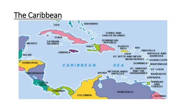
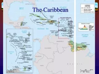
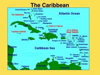
Profile of the Caribbean and its Coastal Areas • Can be divided into Greater Antilles/Lesser Antilles – based on location and geological origin • All islands have high coastline to area ratios, and are therefore particularly vulnerable to coastal hazards. • There are differing levels of risk across the whole Caribbean basin. ECLAC Disaster Assessment Methodology
Coastal Hazards in the Caribbean • Over 6000 lives lost in the Caribbean over past 30 years due to natural disasters. • Greater Antilles • (Cuba, Jamaica, Hispañola, Puerto Rico) • Hurricanes • Floods • Earthquakes • Tsunamis • Lesser Antilles • (St. Maarten to Trinidad) • Hurricanes • Volcanic Eruptions (Ash fallout) • Earthquakes • Tsunamis ECLAC Disaster Assessment Methodology
Coastal Hazards in the Caribbean (cont’d) ECLAC Disaster Assessment Methodology
Hurricanes: A Primary Hazard for Caribbean SIDS Hurricane Keith approaching Belize, 2000
Hurricane Damage: Occurs primarily from: • Hurricane waves; • Storm surge and; • Beach erosion. ECLAC Disaster Assessment Methodology
Hurricane Waves • Waves generated by hurricanes can be very damaging. Estimates of extreme (i.e. design) wave heights made throughout the region are summarized following: Port Zante, St. Kitts (Hurricane Lenny, 1999) ECLAC Disaster Assessment Methodology
Hurricane Waves (cont’d) Deep water waves change in height as they travel in to shallower water. These changes result from: interactions between the waves and the seabed, other waves and wind inputs. At the shoreline, they can be very damaging, eroding shorelines. West coast road, Grenada – Hurricane Lenny, 1999 ECLAC Disaster Assessment Methodology
Hurricane Waves (cont’d) Hurricanes waves at the shoreline can also cause extensive damage to infrastructure, boatyards, etc. Grenada boatyard, Hurricane Ivan, 2004 ECLAC Disaster Assessment Methodology
Hurricane Waves (cont’d) Hurricane waves and storm surge can have tremendous power Trident Hotel, Jamaica after Hurricane Allen, 1980 ECLAC Disaster Assessment Methodology
Beach Erosion • The erosion is exacerbated where there are buildings (i.e. vertical walls) in the wave run-up zone. • Coastal development must be carefully designed so as not to negatively impact adjacent shoreline areas. NE Ambergris Caye, Hurricane Dean, 2007 ECLAC Disaster Assessment Methodology
Beach Erosion (Cont’d) • During a storm event, the extreme wave energy often results in severe erosion of the beach and/or shoreline. • This erosion may reach up to 20-30 m inland, depending on the storm severity, and can totally wipe out beach areas and adjacent infrastructure. Grace Bay, TCI – Hurricane Jeanne (T. Richardson) ECLAC Disaster Assessment Methodology
Components of Storm Surge ECLAC Disaster Assessment Methodology
Components of Storm Surge (cont’d) ECLAC Disaster Assessment Methodology
Characteristics of Storm Surge ECLAC Disaster Assessment Methodology
Examples of Storm Surge High storm waves Inundation of waterfront promenade, Dominica (Lenny, 1999) ECLAC Disaster Assessment Methodology
Hazard Mapping – Storm Surge (Providenciales, TCI) ECLAC Disaster Assessment Methodology
Hazard Mapping – Storm SurgeGrand Turk,TCI ECLAC Disaster Assessment Methodology
Hurricanes in the Caribbean: Historical Account • Records of hurricane damage exist in the archives of the Caribbean for over five centuries; • Since approximately 1900, hurricane records and hurricane characteristics have been maintained by the National Hurricane Center (NHC) and NOAA in Florida, USA. • These records have improved in accuracy and detail since the 1950’s, first with the ability of special reconnaissance aircraft to fly into the eye of these storms, and later, with the aid of satellite imagery. ECLAC Disaster Assessment Methodology
Hurricanes in the Caribbean: Spatial Distribution • The records over the past century show a wide band of hurricane activity across the Caribbean, with the least activity occurring in the area of Trinidad; • In general, damage has occurred from storm surge, waves, wind and rainfall, as all of the islands have aspects that are vulnerable to the hazards; • Latest research indicates possible climate change impacts (more intense storms). ECLAC Disaster Assessment Methodology
Distribution of hurricane activity ECLAC Disaster Assessment Methodology
Flooding: A risk to property and productivity • Over 1300 lives lost to flooding in Caribbean over last 20 years ECLAC Disaster Assessment Methodology
Flooding in the Caribbean: Historical Account • In the Lesser Antilles, flooding has been associated primarily with tropical waves or hurricanes; • Flooding may take the form of excessive ponding, as occurred in Antigua during Hurricane Lenny, or flash flooding as can occur in the more hilly or mountainous islands such as Nevis and Dominica; • In general, all of the islands and their communities are vulnerable to flooding and drainage systems need to be designed to take this into account. ECLAC Disaster Assessment Methodology
Earthquakes: A risk to property and life The Modified Mercalli Scale ECLAC Disaster Assessment Methodology
Earthquakes and Volcanoes in the Caribbean The Caribbean Region, Central and South America are characterized by a belt of seismicity. This is depicted here, with volcanic epicentres shown as green triangles and earthquake epicenters shown as orange dots. ECLAC Disaster Assessment Methodology
Some earthquakes in the Caribbean • Major Earthquakes • Port Royal, Jamaica (1692) • Trinidad (1766) • Antigua (1843) • Minor Events • St. Lucia (1953) • Trinidad (1954) • Antigua (1974) ECLAC Disaster Assessment Methodology
Plate Tectonic Setting ECLAC Disaster Assessment Methodology
Volcanoes: A risk to property and life A significant Hazard in the Lesser Antilles • Soufriere, St. Vincent (1718, 1812, 1902-3, 1979) • Mt. Pelee, Martinique (1902, 1929-32) • Soufriere Hills, Montserrat (1997) ECLAC Disaster Assessment Methodology
Soufriere Hills, Montserrat ECLAC Disaster Assessment Methodology
Before After Plymouth, Montserrat ECLAC Disaster Assessment Methodology
Volcanoes in the Caribbean: Historical Account • 17 Volcanoes have erupted in the Eastern Caribbean. • 25 Volcanic Centres with the potential to erupt. • Approx. 40,000 lives lost in 1902 eruptions (St. Vincent and Martinique). • Warning time has ranged from 14 days to 14 years. • The famous Port Royal disaster of 1692 was initially caused by an earthquake which liquefied an alluvial plane causing it to slide into the sea, the resulting tsunami was several metres in height and caused over 2000 deaths. ECLAC Disaster Assessment Methodology
Tsunamis: are we at risk? • More a problem in the Lesser Antilles • Caused by ocean centred earthquakes, or volcanic eruptions. • Greatest risk presently posed by “Kick ‘em Jenny” SeaBeam image of Kick 'em Jenny constructed from measurements taken from the NOAA Research Vessel Ronald H. Brown on March 12 2002. ECLAC Disaster Assessment Methodology
Tsunamis in the Caribbean: Historical Account Summary Table of Tsunami Activity ECLAC Disaster Assessment Methodology
Tsunami Risk Zones • Tsunami triggered by seismic activity; submarine landslides. • Resulting waves could be of the order of 4m (Cat 1-2) ECLAC Disaster Assessment Methodology