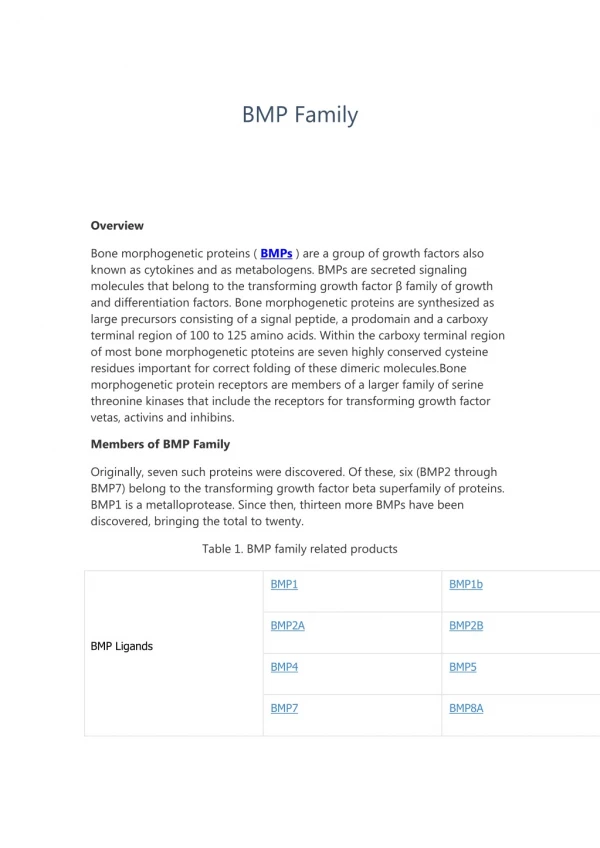
Final BMP Modeling Workshop
Final BMP Modeling Workshop. September 29, 2011 UB Geography Department Sponsored by the Buffalo District of the US Army Corps of Engineers. Workshop Outline. Intro to Baseline Models & Case Studies Overview of BMPs by Scale Large-Scale Watershed Models (ArcSWAT) Break

Final BMP Modeling Workshop
E N D
Presentation Transcript
Final BMPModeling Workshop September 29, 2011 UB Geography Department Sponsored by the Buffalo District of the US Army Corps of Engineers.
Workshop Outline Intro to Baseline Models & Case Studies Overview of BMPs by Scale Large-Scale Watershed Models (ArcSWAT) Break Small –Scale Hillslope BMPs (WEPP) Lunch
Workshop Outline Medium-Scale Watershed BMPs (GeoWEPP) Break Modeling Flood Levels & BMPs (HEC-GeoRAS) Break Instructor Assisted Self-Paced Exercises Wrap-up & Closing Comments
Workshop Outline Intro to Baseline Models & Case Studies Overview of BMPs by Scale Large-Scale Watershed Models (ArcSWAT) Break Small –Scale Hillslope BMPs (WEPP) Lunch
What Have We Done? • Engaged with Stakeholders • Acquired / modified / refined / verified required data • DEM, soils, landuse, cross section profiles • Developed verifiable baseline models (Catt Creek and Clear Creek) • Conducted field trips and workshops for two-way knowledge transfer • Delineated watershed and stream networks to maximize sub-basins < 5 sq km • Chose BMPs to simulate • Chose modeling software to match basin size and BMPs to simulate • Selected sub-basins to model • Tested modeling software inputs or parameters to simulate BMPs • Evaluated model results Baseline Models & Case Studies
What’s Next To Do? • Conduct BMP Modeling Training Workshop (today) • Continue to engage with Stakeholders • Acquire / modify / refine / verify required data • DEM, soils, landuse, cross section profiles • Continue two-way knowledge transfer • Incorporate lessons learned in classroom setting • Develop and deliver a final written report Baseline Models & Case Studies
What Else Have We Done? • Refined the Erie County LiDAR data to recalculate bank erosion volumes compared to IPLER/RIT LiDAR. Baseline Models & Case Studies
What Else Have We Done? Black = Strong Returns White = No Returns Baseline Models & Case Studies
What Else Have We Done? Red = Erosion Yellow = Neutral Green = Deposition Baseline Models & Case Studies
Workshop Outline Intro to Baseline Models & Case Studies Overview of BMPs by Scale Large-Scale Watershed Models (ArcSWAT) Break Small –Scale Hillslope BMPs (WEPP) Lunch
NaturalVariability& Role of Scale Log space km 1 yr 1 min 1 hr 1 day 1 mon 10 yrs 100 yrs 1,000 yrs 10,000 yrs 1 sec -6 infiltration / moisture structure texture splash grass 1 cm2 micro interrill canopy 1 dm2 -4 tillage ridge depth plot 1 m2 buffer rill horticulture 100 m2 -2 catena hill- slope breeze crop orchard stand 1 ha gully sub-shed 1 km2 forest wood 0 fluvial 100 km2 landscape evolution water shed thunder storm 10,000 km2 2 basin 1MM km2 front longwaves El Niño climate change globe 4 -8 -6 -4 -2 0 2 4 Log time years Vegetation Management Unit Weather / Climate Soil / Lithology Erosion Process Topographic Scale
BMPs by Scale John Whitney’s most important agricultural BMPs on WNY farms: • Crop Rotation • Conservation Tillage • Nutrient Management • Pest Management • Buffers Other supporting practices include: • Cover Crops (often part of the Conservation Tillage/Residue Management package) but also important for organic matter improvements • Waste Management • Contour Farming • Strip Cropping BMPs by Scale
Cover Crop Rotation Patterns BMPs by Scale
Cover Crop Options BMPs by Scale
Scale Dependent Model Simulations • Models can only “see”/represent features larger than the basemap grid cell size • Historic DEM cell sizes range from 90 m to 10 m, but most current USGS DEM areas are 30 m or 10 m grid cell sizes • Models often aggregate landuse, soil, slope for the entire sub-basin to the DEM grid spatial reference and resolution • BMPs which involve small changes like riparian grass buffers can be modeled without a spatial reference • WEPP models hillslopes (representative and real) • GeoWEPP models small sub-basins (< 5 km2) • ArcSWAT models for larger watershed (> 5 km2) • HEC-GeoRAS models single channels and overbank area Model Scale Dependencies
WEPP Hillslope Interface Model Scale Dependencies
Watershedvs. FlowpathMethod • Watershed – aka offsite assessment • Measures sediment yield at the outlet point • Less memory intensive • Take less time • Identifies problem hillslopes • Uses Dominant Soil and Dominant Landuse • Flowpath – aka onsite assessment • Measures soil loss at each raster cell • Memory hog • Can take some time • Identifies problem areas within a hillslope • Uses Soil and Landuse of each cell Model Scale Dependencies
Method Comparison Flowpath Watershed Model Scale Dependencies
Watershedvs. FlowpathMethods Flowpath Watershed Model Scale Dependencies
Short-term & Long-Term Processes • Short-term: • Single storm events which demonstrate watershed responses to baseline conditions coupled with localized weather patterns • 5-year window (event year plus 2 yrs before and after) • Long-term: • Statistically defined weather conditions based on historic patterns which operate over much longer periods • 50-100 year window (models daily/hourly averages over time) • Allows return periods to be computed (100-yr, 500-yr, 1000-yr storms and floods).
Workshop Outline Intro to Baseline Models & Case Studies Overview of BMPs by Scale Large-Scale Watershed Models (ArcSWAT) Break Small –Scale Hillslope BMPs (WEPP) Lunch
Workshop Outline Intro to Baseline Models & Case Studies Overview of BMPs by Scale Large-Scale Watershed Models (ArcSWAT) Break Small –Scale Hillslope BMPs (WEPP) Lunch
Workshop Outline Intro to Baseline Models & Case Studies Overview of BMPs by Scale Large-Scale Watershed Models (ArcSWAT) Break Small –Scale Hillslope BMPs (WEPP) Lunch
Workshop Outline Intro to Baseline Models & Case Studies Overview of BMPs by Scale Large-Scale Watershed Models (ArcSWAT) Break Small –Scale Hillslope BMPs (WEPP) Lunch
Workshop Outline Medium-Scale Watershed BMPs (GeoWEPP) Break Modeling Flood Levels & BMPs (HEC-GeoRAS) Break Instructor Assisted Self-Paced Exercises Wrap-up & Closing Comments
Workshop Outline Medium-Scale Watershed BMPs (GeoWEPP) Break Modeling Flood Levels & BMPs (HEC-GeoRAS) Break Instructor Assisted Self-Paced Exercises Wrap-up & Closing Comments
Workshop Outline Medium-Scale Watershed BMPs (GeoWEPP) Break Modeling Flood Levels & BMPs (HEC-GeoRAS) Break Instructor Assisted Self-Paced Exercises Wrap-up & Closing Comments
Workshop Outline Medium-Scale Watershed BMPs (GeoWEPP) Break Modeling Flood Levels & BMPs (HEC-GeoRAS) Break Instructor Assisted Self-Paced Exercises Wrap-up & Closing Comments
Workshop Outline Medium-Scale Watershed BMPs (GeoWEPP) Break Modeling Flood Levels & BMPs (HEC-GeoRAS) Break Instructor Assisted Self-Paced Exercises Wrap-up & Closing Comments
Workshop Outline Medium-Scale Watershed BMPs (GeoWEPP) Break Modeling Flood Levels & BMPs (HEC-GeoRAS) Break Instructor Assisted Self-Paced Exercises Wrap-up & Closing Comments
What Have We Done? • Engaged with Stakeholders • Acquired / modified / refined / verified required data • DEM, soils, landuse, cross section profiles • Developed verifiable baseline models (Catt Creek and Clear Creek) • Conducted field trips and workshops for two-way knowledge transfer • Delineated watershed and stream networks to maximize sub-basins < 5 sq km • Chose BMPs to simulate • Chose modeling software to match basin size and BMPs to simulate • Selected sub-basins to model • Tested modeling software inputs or parameters to simulate BMPs • Evaluated model results Wrap-up & Closing Remarks
What’s Next To Do? • Conduct BMP Modeling Training Workshop (today) • Continue to engage with Stakeholders • Acquire / modify / refine / verify required data • DEM, soils, landuse, cross section profiles • Continue two-way knowledge transfer • Incorporate lessons learned in classroom setting • Develop and deliver a final written report Wrap-up & Closing Remarks