Download
1 / 2
20 likes | 105 Views
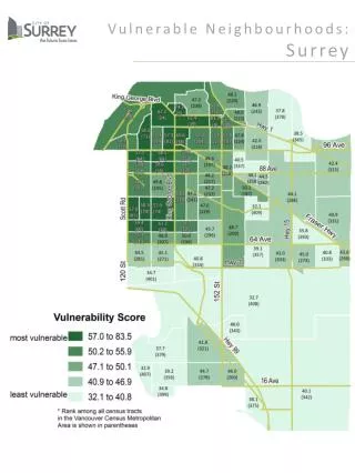
The Vulnerability Index ranks Surrey's census tracts based on factors like poverty, education, and immigration, revealing critical neighborhood insights for policy and planning.

E N D
Vulnerable Neighbourhoods: Surrey
Measuring Vulnerability An expanding body of research shows that ‘place matters’ at the neighbourhood level. Increasingly, there is a trend toward more concentrated pockets of poverty within cities across Canada. The Index* was developed to measure vulnerability in urban neighbourhoods. A “vulnerability score” was calculated for each of Metro Vancouver’s 410 census tracts. Based on this, census tracts were ranked from most vulnerable(highest score) to least vulnerable (lowest score). The vulnerability score was computed from seven Census variables that were tested and found to have a high degree of correlation. The variables included in the calculation are: • Share of the population living below the Low Income Cut-Off (LICO), • Share of the population under six living below LICO, • Unemployment rate, • Share of the population fifteen and over with less than a high school education, • Share of families that are lone-parent families, • Share of the population that are recent immigrants, and • Share of renter households spending more than 30% of their income on shelter. The map indicates the vulnerability score for each of Surrey’s 78 census tracts along with its rank among all 410 census tracts in Metro Vancouver. * This index was created by the Globalization and Health of Canadians Project, funded by the Canadian Institutes of Health Research.