Download
1 / 64
670 likes | 925 Views
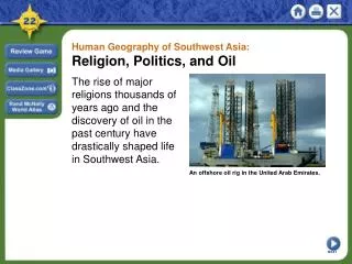
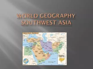
Unit 8: North Africa and Southwest Asia. Political Map of Southwest Asia. Physical Map of Southwest Asia. Physical SW Asia. Arabian Peninsula . Anatolian Peninsula. Map of North Africa. Waterways of SW Asia. Red Sea. Black Sea. Waterways of SW Asia. Dead Sea: so salty you cannot sink.

E N D
Physical SW Asia Arabian Peninsula Anatolian Peninsula
Waterways of SW Asia Red Sea Black Sea
Waterways of SW Asia Dead Sea: so salty you cannot sink Jordan River: natural boundary b/w Israel and Jordan
Cradle of Civilization - Mesopotamia Tigris River Euphrates River
Deserts, Oasis’, & Salt Flats Rub al-Khali: Empty Quarter. “place no one comes out”, most of SW Asia is Arid & Semiarid Salt Flat: Dasht-e Lut & Dsaht-e Kavir in Iran
Ethnic and Religious Groups Ethnic Groups Religious Groups
Climates & Ecosystems Climates of SW Asia Ecosystems of SW Asia
Physical Characteristics of N. Africa • Mediterranean coastal climates--- hot, sunny summers, cool, rainy winters • Need to live near a water source • Ppl along coast have easier contact with ppl than those in the interior • No connecting navigable rivers
Sahara Desert Largest desert in the world, 3,000 miles 134 degrees in the day and below freezing at night 20% sand Camels can go up to 17 days without water Rely on aquifers and oasis’
European Influence on N. Africa • French Colonies: Libya, Algeria, Tunisia, Morocco. • English Colonies: Egypt, Saudi Arabia, Afghanistan, Iraq, Palestine
Early Movement • The Berbers were the original inhabitants of N. Africa & were farmers and herders • Camels were introduced during Roman rule from Central Asia & were very well adapted to desert climate • 1st time reg. trade was est. crossed desert in caravans
Settlement Patterns • ½ of pop lives in rural villages • Sm. Houses of sun-dried brick • rise at dawn, nap midday b/c too hot, work until dusk • still use wooden plows
Settlement Patterns: Desert Nomads in Africa Tuareg --- speak own language, only Berber language with a written form, means “free men”, severe drought has caused some to resort to farming, mostly located in Burkina Faso and Libya
The Water Solution Iceberg Project abandoned in 1981 National Water Carrier Project in Israel– carries water from N. to central & S. Desalination Plants: removes salt from ocean water, very expensive, still too salty for irrigation so used for sewage systems Fossil Water: old water from deep underground aquifers
Water Systems Irrigation Canal: deliver water to arid regions, evaporates quickly, used in Oman Noria: waterwheel run by flow water or animal power used to lift water from the river to the fields (Syria) Drip Irrigation: reduces evaporation, used in the Negev Desert in Israel Qanat: system of underground brick-lined tunnels and wells that collect runoff water from the mountains
Nile River • World’s longest river – 4,160 miles, flows North • Empties into Nile Delta (extremely fertile) • The Fellaheen (Egyptian peasants) grow impressive crops without modern machinery • Population – 68 million (99% live along Nile R.) • High population density (2,700 ppl per sq mi) • 2 major cities: Cairo & Alexandria
Controlling the Nile • Basin Irrigation: long walls built around fields to trap water and silt (didn’t work yr round) • Reservoir: Lake Nasser (300 mi.) on the Aswan Dam, caused an increase in Malaria, but provides steady water supply • Perennial IrrigationSystem
Aswan High Dam - stopped flooding of Nile, 35 % of Egyptian farmland have a high salt content, but increased farmland by 50%. However, b/c flooding stopped so did the deposit of new silt
Suez Canal • links Med. Sea and Red Sea opened in 1869 – made Egypt vital link • About 105 mi long • Reduces the 12,300 mi long trip between London and Mumbai to 7,200 mi
Oil from the Sand Petroleum = Oil Discovered in SW Asia in 1920s World’s largest oil field is al-Ghawar in Saudi Arabia in the Rub al-Khali desert and contains ¼ of Saudi Arabia’s oil reserves OPEC: Organization of Petroleum Exporting Counties
Processing Petroleum Drills pump out the crude oil into storage tanks Natural gas, water, and sediments are removed and oil is sent to a pumping station Crude oil is sent to refineries either in tankers or by pipelines At the refinery crude oil is converted into useful products like gasoline Products are transported worldwide
More Oil Facts Oil Consumers Oil Producers
Oil: A Strategic Commodity 64 % of world’s oil deposits 34% of natural gas reserves 44.5 million barrels a day – 50% of world’s demand Oil prices unstable Use oil profits to modernize and industrialize Use oil profits to diversify economy Kuwait: free public education
Economies Subsistence Farming and Nomadic Herding Oil, hydroelectricity, natural gas, minerals, need for other resources
Islam • Muhammad as 1 true prophet, but belief in other prophets • Qur’an – words of God; Hadith – words of Muhammad • 5 pillars of Faith • 6 Articles of Faith
Effects of Islam on SW Asia Major religion for Bahrain, Kuwait, Oman, Saudi Arabia, Qatar, United Arab Emirates, Syria, Lebannon, Jordan, Iran, Iraq, Afghanistan, and Yemen – many are theocratic govts. Mecca: holiest city of Islam (where Muhammad spend much of his life) 5 Pillars of Faith: (Faith, Prayer 5x a day, Charity, Fasting- Ramadan, Pilgrimage to Mecca) Mosques: Muslim place of worship
Islam in North Africa • Most N. Africans are Muslim • 1st brought to Africa in 632 CE • All N. African coast Muslim by 750 CE • By 1500 extended through the Sahara • Mostly Sunni
Basic Beliefs of Judaism • One God, no form, creator, pray to him alone • Moses as chief prophet • Torah as Law from God, passed down through Moses, can’t be changed • Coming of the Messiah • Rewards good, punishes bad • Food must be Kosher
Jerusalem: Holy for Jews Capital of Israel Temple Mount: site of King Solomon’s 1st temple and the spot where Abraham was prepared to sacrifice his son to God Site of the 2nd temple Western Wall: Wailing Wall- last pieces of the 2nd wall that was destroyed by Romans in 70 CE
Christianity • Breakaway sect of Judaism, followers of Jesus Christ • 12 disciples, Virgin Mary, son of God, original sin • Bible – Old (before Jesus) & New (after Jesus) Testament • Beliefs: • 1. God • 2. Trinity • 3. Bible • 4. Death & Resurrection of Jesus • 5. Return of Jesus • 6. Salvation & Punishment
Jerusalem: Holy for Christians Crusades: Christians fought for control of the city from Muslims – lost Site of Jesus’ crucifixion
Jerusalem: Holy for Muslims Dome of the Rock: houses the spot where Muhammad ascended to heaven, located on the Temple Mount Al-Aqsa: mosque
Creation of the State of Israel Balfour Declaration: UN divides Palestine into 2 states: 1 for the Jews and 1 for the Arabs Arabs did not agree, but Israel was formed anyway in 1948 Surrounding Arab nations launched war against Israel and lost b/c Israel was supported by the UN (aka USA & UK)
Who does the land belong to? Ottoman Empire: 1520 – 1922, Muslim based, Turkish govt., fell at the end of WWI, lands split between France and England French: Syria (1946) & Lebanon (1943) British: Israel & Jordan (called Palestine) Zionism: goal to create a Jewish homeland By 1914: 12% of Palestine was Jewish Jews poured into Palestine to escape the Holocaust British stopped immigration in 1939
West Bank and the Gaza Strip The West Bank and Gaza Strip were under Israeli control until 1960s Palestine Liberation Organization (PLO) was formed to regain the land for the Arabs West Bank and Gaza Strip are now under Arab control and are a safe zone for Palestinian Arabs
Palestinian Refugees In 1949 the UN created 53 Palestinian refugee camps They were supposed to be temporary Each camp holds b/w 35,000 – 50,000 people Israeli govt. controls all movement in and out of the camps Education, money, food, health care provided by the UN
Life in Israel Today School from 5-15 years At 15 choose b/w tech school or academic school or the workforce Drive & get married at 17 yrs Enter the military at 18: 3 yrs for men; 2 years for women, but women no active combat Some restaurants have separate dining areas for men and women (Arab) Most ethnically diverse country in the world
Kurds Stateless nation 1988 Iraq dropped mustard gas bombs on Kurdish settlements killing 5,000 ppl Kurdistan: in parts of Turkey, Iran, Iraq, and Syria Kurds make up 20% of Turkey are majorly repressed
Sunni vs Shi’ite Sunni: 83 % of Muslims Shi’ite: most Iranians
Persian Gulf War War for control over the oil fields 1990 Iraq (under Saddam Hussein) invaded Kuwait US and 32 other countries fought to expel Iraq Iraq set fire to 700 oil wells US and UN won